Satellite Courses
WMO Standards
The satellite courses organised by EUMeTrain all comply with the competencies and standards identified by WMO.
These standards are complemented by EUMeTrain with features considered to be important and further stress the use of EUMETSAT satellite data for nowcasting and forecasting purposes.
The courses are organised in, what is also known as, a blended learning approach, in which a mixture of online lectures and classroom phase, is offered. Throughout the whole course the progress of the students is evaluated and upon success a certificate is handed out.
For developing the course material, as well as to finance travel costs for the classroom phase, a course fee for participation is mandatory.
The courses are repeated every two years. The lectures are recorded and can be played back to allow self study.
Synoptic and Mesoscale System Analysis 2021
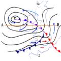
From January 11 to February 22, 2021 EuMeTrain organized an online course on Synoptic and Mesoscale System Analyses. This course focused on improving forecaster skills by using the available satellite data in synoptic and mesoscale analysis. Examples and cases mainly refered to European and near adjacent Atlantic regions. The participants learned to use the satellite imagery in combination with other meteorological data cources in order to interpret mid-latitude cyclones, fronts, frontal sub-structures, mesoscale features in cold air, summer convection, orographic features and shallow clouds.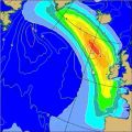
EUMeTrain Marine Course 2019
The 4th EUMeTrain Marine Course was delivered during the spring of 2019 in a period of 8 weeks, from 26 March to 17 May. The course focused on analyzing and monitoring marine weather together with the experienced and well known teachers like Ad Stoffelen (KNMI) and Jean Bidlot (ECMWF).
Synoptic and Mesoscale Analysis of Satellite Images 2018
The course on Synoptic and Mesoscale Analysis of Satellite Meteorology is teaching you how to use satellite images in your operational work. Analyzing a satellite image in terms of conceptual models is the best way to learn to retrieve a mental weather picture and it can further help you in understanding the weather patterns and therefore become a better forecaster. The course is designed for operational forecasters and meets the requirements of the WMO.In addition to the existing material from the 2016 edition, there are some new lectures and some new material on the course website.

EUMeTrain Basic Satellite Course 2018
The Basic Satellite Course is teaching the basics of satellite meteorology: analyzing surface features, describing clouds and their characteristics and recognizing other phenomena on different products. It was held in the period of 7 weeks on the Moodle platform. The course was designed to address the oparational forecasters and to meet the WMO Satellite Competences requirements.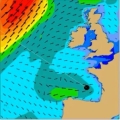
EUMeTrain Marine Course 2017
The 3rd Eumetrain Marine Course was delivered on the Moodle platform and was held in the period of 8 weeks. The course focused on analyzing and continually monitoring marine weather situations, forecasting marine weather phenomena and warnings of hazardous phenomena, all of that based on the WMO Marine Weather Forecaster Competentices requirements.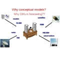
Synoptic and Mesoscale Analysis of Satellite Images - 2016
The course on Synoptic and Mesoscale Analysis of Satellite Meteorology is teaching you how to use satellite images in your operational work. Analyzing a satellite image in terms of conceptual models is the best way to learn to retrieve a mental weather picture and it can further help you in understanding the weather patterns and therefore become a better forecaster. The course is designed for operational forecasters and meets the requirements of the WMO.
Synoptic and Mesoscale Analysis of Satellite Images - 2014
The EUMeTrain - Eumetcal course on Synoptic and Mesoscale Analysis of Satellite Meteorology is teaching you how to operationally parse a satellite image into conceptual models. Analysing a satellite image in terms of conceptual models is the best way to learn to retrieve a 3D or even a 4D (with time being the fourth dimension) mental weather picture. The course is designed for operational forecasters and meets the requirements of the WMO.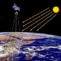
Basic Satellite Meteorology Course - 2014
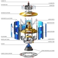
The Basic Satellite Meteorology Course 2014 focuses on satellite systems, sensors and instruments, on the information content of spectral channels and last but not least on the high variety of meteorological products derived from satelliote data. This course is aiming at students and professionals in meteorology who want to keep up to date on the present status and recent developments in the field of satellite meteorology.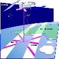
Marine Forecasting Course - 2013
The Marine Forecasting Course is a distance learning course designed to train forecasters to improve the quality of marine forecasting and nowcasting through the better use of satellite and model data. The course aims at preparing forecasters in the core skills related to marine nowcast and forecasts.