ePort
Concept of ePort
ePort uses the technical basis of Visual Weather © developed by IBL. It allows you to combine a range of EUMETSAT provided satellite data with satellited derived products and numerical model fields.All images generated are stored in an archive which makes it possible for you to do a qualitative research.
Technical information:
Contains forecast data from ECMWF IFS model. 6-hour forecast data for 00, 06, 12, 18 UTC and 9-hour forecast data for 03, 09, 15, 21 UTC.
The resolution of the global model fields: 0.5° x 0.5°.
Temporal frequency of images: 3 hourly.
The resolution of satellite images (at nadir): depens on the used instrument - GOES ABI: 1km VIS, 0.5km 0.6 μm band, 2km IR; MSG SEVIRI (3km, 1km HRV), Himawari AHI (same as GOES).
Showcase
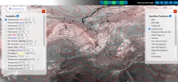
The ePort Pro
ePort PRO is the more powerful of the two versions of the platform. It contains images and products from geostationary satellites (GOES, MSG and Himawari) and the ECMWF model fields, including vertical cross sections and model sounding data.
To access the portal either use the menu on top of the page (ePort - ePort PRO) or click on one of the images down below.


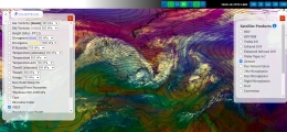
The ePort JavaScript
The ePort JavaScript also uses the back-end service of Visual Weather, however, the front-end display, kindly provided by Sergio Gallego from the Meteorological Service of Catalonia, is a lighter version compared to ePort Pro with only one satellite (MSG) and several products available. It also includes the ECMWF model data.
To access the the portal either use the menu on top of the page (ePort - ePort JavaScript) or click on either of images below.