HSAF User Workshop 2022
![]()
The 5th H SAF User Workshop supported by EUMeTrain was held in online mode from 24th to 28th January 2022. The workshop along with EUMETSAT Satellite Application Facility on Support to Operational Hydrology and Water Management (H SAF) aimed to provide satellite derived products related to precipitation, soil moisture and snow over land in support to hydrology and water management. In addition, H SAF provides both continuous quality assessment of products and the evaluation of their hydrological impact for the benefit of the end user communities.
Session 1 - 24 January 2022
An introduction of the HSAF project, the history of the SAFs, the introduction of the HSAF Workshop and its agenda from the main organizers.
Recording A. Jann, F. Zauli, L. Schueller and S. Puca
The EUMETSAT Satellite Application Facility on Support to Operational Hydrology and Water Management (H SAF) develops and provides operational satellite products for precipitation, snow and soil moisture. These satellite products have a wide range of applications, but especially play a key role in numerical weather prediction.
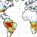
The H SAF soil moisture product suite is composed of surface and root zone soil moisture products available at various spatial resolution, ranging from 1 km to 50 km. Surface Soil Moisture (SSM) products are based on backscatter observations provided by the Advanced Scatterometer (ASCAT) onboard the series of Metop satellites using the EUMETSAT H SAF TU Wien soil moisture retrieval algorithm, whereas Root Zone Soil Moisture (RZSM) products assimilate H SAF SSM products within the ECMWF/H SAF land data assimilation system. At the moment, two ASCAT instruments are currently operational on-board Metop-B and Metop-C.
Recording S. Hahn and D. Fairbairn
The EUMETSAT Satellite Application Facility for Operational Hydrology and Water Management (H SAF) provides satellite products and user services in support to Operational Hydrology, Meteorology, Risk Management and Water Management. Since 2005, H SAF science and research bridge into operations through the development and dissemination of soil moisture, precipitation and snow products based on the exploitation of primary EUMETSAT missions. During the fourth Continuous Development and Operations Phase (CDOP-4, from 2022 to 2027), H SAF products will be primarily based on the Meteosat Third Generation (MTG) and the EUMETSAT Polar System -Second Generation (EPS-SG) missions. Current products are based on the use of the full constellation of microwave (MW) radiometers for Level 2 passive microwave (MW) precipitation products and for MW/IR combined products for near-real time applications over the Meteosat Second Generation (MSG) full disk area. The presentation will provide a full overview of the current status and future development of the operational precipitation product portfolio as well as the product quality assessment strategy and results. Examples of applications for specific case studies will be also presented.
Recording G. Panegrossi, L. Ciabatta and M. Petracca
Reliable snow cover extent is of vital importance to have a comprehensive understanding for present and future climate, hydrological, and ecological dynamics. Development of methodologies to obtain reliable snow cover information by means of optical and microwave remote sensing (RS) has long been one of the most active research topics of the RS community. Operational snow products namely H10 (Snow detection (snow mask) by VIS/IR radiometry), H11 (dry/wet by MW radiometry), H12 (Effective snow cover by VIS/IR radiometry AVHRR), H13 (Snow Water Equivalent(SWE)by MW radiometry), H31 (Snow detection by VIS/IR radiometry), H32 (Effective snow cover by VIS/IR radiometry AVHRR) have been developed since 2008 within HSAF. Considering different characteristics of snow for mountainous and flat areas, various algorithms are used in producing the snow products for flat and mountainous areas, and then the products are merged to have a single snow product. The development of new snow products is in progress. The presentation will provide an overview of existing and future operational satellite-derived snow products of H SAF portfolio. In the last part of the presentation, there will be a short introduction of quality assessment. After a brief recap of all available operational and pre-operational products, the performances of the products and the new validation strategy using high-resolution satellite data will be discussed, with some interesting case studies of the latter.
Session 2 - 25 January 2022
Morocco, as many African countries, has limited observed precipitation data that is a major obstacle for water management, flood monitoring and climate change adaptation planning using hydrological models. The objective of this study is to evaluate satellite rainfall products for hydrological modelling over 12 basins in Morocco using four hydrological models: IHACRES, MISDc, GR4J and CREST. Six satellite products are used in this analysis: the H03, H05, H64 and H67 HSAF products, in addition to SM2RAINASCAT product and GPM IMERG-E. The results showed that the best results to reproduce river runoff are achieved with the SM2RAINASCAT and H64 products, using the CREST and MISDc hydrological models. However, there are strong interplays between the different precipitation products and hydrological model structures in different basins, highlighting the need to carefully select hydrological models according to the intended application. This first evaluation over 12 Moroccan basins suggests that the use of satellite rainfall products for hydrological modelling could a viable alternative to observed rainfall in basins where precipitation is not monitored.
Thales has developed an automatic flood forecast tool combining two kinds of information used as input of a Machine Learning algorithm:
- Forecasted flows at the outlet of the watershed of interest, obtained with an ensemble data assimilation using a particle filter;
- Current soil state information from space-based observations;
The prototype allows forecasting time series of flood occurrence associated with a confidence index for a 6-day flood forecast with a 6-hour time-step. It has been tested and validated on a French watershed with good results.
In the context of climate warming, the frequency and the intensity of extreme events such as droughts is increasing, and better modelling of the response of vegetation to climate is needed. Monitoring the impact of extreme events on terrestrial surfaces involves a number of variables of the soil-plant system such as surface albedo, the soil water content and the vegetation leaf area index (LAI). These variables can be monitored by either using the unprecedented amount of data from the Earth observation satellite fleet, or using land surface models. Another solution consists of combining all available sources of information by assimilating satellite observations into models. In this work, level 1 ASCAT backscatter values (sigma0) are assimilated in the ISBA land surface model of Meteo-France using the LDAS-Monde tool. It is shown that the assimilation of sigma0 alone is able to markedly improve the simulated LAI and soil moisture.
Recording Jean-Christophe Calvet
Investigation of drought variability requires long term rainfall dataset with high spatial and temporal resolution. The goal of this study are as follow: 1) to develop the long-term climatological SM2RAIN datasets for the period of 1998–2020 at 0.25° spatial and monthly temporal resolution by merging two rainfall SM2RAIN products including SM2RAIN-CCI and SM2RAIN-ASCAT, and 2) to the analysis of drought based on standardized precipitation index over the USA. Results indicated that the most significant decreases in the monthly rainfall trends appear in November. In addition, drought occurred during 2003, 2007, and 2012 over most parts of the USA.
Primary satellite data processed into higher-level products are still used less frequently, especially in the context of processing by NWC SAF software, or directly by SAF products received by the EUMETCast Satellite receiving system. Such products include the hydrology support products of the EUMETSAT H SAF (Hydrological Satellite Application Facility). SHMÚ, as a member of the consortium, has long been involved in the task of validation of products for precipitation detection and hydrological applications of these products. In this article we present the operational satellite products for precipitation detection, the procedure for their validation and a case study presenting the use of these products in evaluating the long-term accumulated precipitation. Accumulated precipitation can be used to monitor periods of droughts with precipitation deficits and surpluses. The ambition of this work is to show future users of satellite data that satellite products of a higher level of processing have the potential for climatological studies. A significant increase in this potential is expected in the near future with the launch of the new generation of MTG (third generation Meteosat) and EPS-SG (second generation European Polar System) satellites.
During the last week of October 2021 an intense Mediterranean hurricane (medicane), named Apollo, affected many countries on the Mediterranean coasts. The deaths toll peaked up to 7 people, due to flooding from the cyclone in the countries of Tunisia, Algeria, Malta, and Italy.
The Apollo medicane persisted over such areas for about one week (24 October – 1 November 2021) and produced very intense rainfall phenomena and widespread flash flood and flood episodes especially over eastern Sicily on 25-26 October 2021.
CIMA Foundation hydro-meteorological forecasting chain, including the cloud-resolving WRF model assimilating radar data and in situ weather stations (WRF-3DVAR), the fully distributed hydrological model Continuum, the automatic system for water detection (AUTOWADE), and the hydraulic model TELEMAC-2D, has been operated in real-time to predict the weather evolution and the corresponding hydrological and hydraulic impacts of the medicane Apollo, in support of the Italian Civil Protection Department early warning activities and in the framework of the H2020 LEXIS and E-SHAPE projects.
This work critically reviews the forecasting performances of each model involved in the CIMA hydrometeorological chain, with special focus on temporal scales ranging from very short-range (up to 6 hours ahead) to short-range forecasts (up to 48 hours ahead).
Session 3 - 25 January 2022
We demonstrate the use of the EUMETSAT HSAF soil moisture (H116, SM) and SM2RAIN (H64) products to predict yields for Morocco and Senegal. Root-zone SM was calculated from SM, and NDVI was used as a vegetation indicator. Data on yields was obtained from the Food and Agriculture Organization of the United Nations.
Yield prediction was done for main crops using multiple linear regression and a time for space approach. SM improved yield prediction, especially early in the growing season, improving early warning capabilities. NDVI showed better predictions later in the growing season. SM2RAIN outperformed other benchmark rainfall datasets.
Recording Mariette Vreugdenhil
EUMETSAT provides a prototype Data Cube for Drought and Vegetation Monitoring, and tools to manipulate the data in the cube. This prototype consists of long-term data records on a regular latitude / longitude grid and in CF-compliant NetCDF via THREDDS.
The prototype seeks to explore how well EUMETSAT and partners can bring together data from multiple sources and from multiple grids to ease barriers to use of the data for thematic applications.
This presentation reports on the lessons learnt as regards the creation, provision and use of the data cube.
Recording Christine Träger-Chatterjee
In order to better capture the complexity of interlinked natural phenomena related to the atmosphere, ocean, hydrosphere and cryosphere, WMO has adopted a holistic Earth System monitoring approach. The operational implementation of this approach is supported by WMO Congress decisions related to the establishment of a global basic observing network GBON, and the adoption of a unified data policy, aimed at improving the sharing and interoperability of data among users, contributing to better numerical weather prediction and more accurate flood and drought forecasts. To achieve these results, it is important to benefit from emerging approaches in order to combine different data sources such as satellites, citizen observations, low-cost devices, Internet of Things, Big Data. This approach also allows ensuring at least partial information overt hose vast areas of the world where conventional state-funded monitoring approaches are insufficient. WMO is developing technical solution (standards, best practices) to overcome the discrepancies in data quality and the multiplication of different data format. In this context satellite. WMO, in coordination with its Expert Network is working on updating the satellite data and product requirements for Flood Forecasting and seasonal and long term hydrological forecasts and outlook.
The São Francisco River Basin (SFRB) plays a key role for the agricultural and hydropower sectors in Northeast Brazil (NEB). The purpose of this study is to provide a comprehensive evaluation of extreme drought events in terms of occurrence, persistence, spatial extent, severity, and impacts on streamflow and soil moisture over different time windows between 1980 and 2020. The Standardized Precipitation-Evapotranspiration Index (SPEI) and Standardized Streamflow Index (SSI) at 3- and 12- month time scales derived from ground data were used as benchmark drought indices. The selfcalibrating Palmer Drought Severity Index (scPDSI) and the Soil Moisture and Ocean Salinity-based Soil Water Deficit Index (SWDIS) were used to assess the agricultural drought. The Water Storage Deficit Index (WSDI) and the Groundwater Drought Index (GGDI) both derived from the Gravity Recovery and Climate Experiment (GRACE) were used to assess the hydrological drought. The SWDISa and WSDI showed the best performance in assessing agricultural and hydrological droughts across the whole SFRB.
Session 4 - 26 January 2022
Evapotranspiration (ET) is a key component of the Earth System coupling land-atmosphere exchanges of water, energy and carbon. Due to the complex nature of the processes involved (radiation, boundary layer turbulence, vegetation status, soil moisture) it is very challenging to observe (locally and from Satellite) and to model. LSA SAF evapotranspiration product takes advantage of satellite radiation and soil moisture estimates to diagnose ET using a surface energy balance approach. This talk will present an overview of the LSA SAF ET products with particular focus on the use of HSAF soil moisture in operations (H14 and future H26) and in the production of the climate data record (H141).
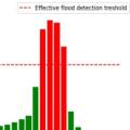
This work analyses the performances of the H SAF precipitation products during the Mediterranean cyclone Apollo. The cyclone Apollo occurred between October 25th and October 29th, 2021 with its maximum on October 28th and 29th when it approached the coasts of Sicily causing floods and damages to civil structures. The present work aims to describe the cyclone evolution by exploiting the satellite-based Level 2 and Level 3 H SAF precipitation products. The analysis focuses on the reconstruction of the precipitation pattern and of the quantitative amount thanks a direct comparison with ground-based measurements.
Satellite-based remote sensing provides a significant contribution for hydrological predictions due to its wide coverage and increasing tempo-spatial resolutions. Although current observed areal precipitation estimation is mainly based on point rain gauge measurement interpolation, the ability to deduce spatially distributed data from point measurement depends on the design and density of the sensor network.
A possible approach to have a correct representation of the rain field at the hydrological scale (up to a few hundred meters) could be to merge rain gauge data with gridded rainfall data obtained from remote sensing techniques, and the availability of such data in near-real time is a unique opportunity for the operational hydrology community. In this study we propose the application of advanced downscaling techniques based on Cellular Automata Algorithm for rainfall spatialisation using satellite precipitation products for hydrological applications. The method proposed to merge rainfall estimates measured in different spatial scales is based on the data assimilation concepts with particular emphasis on the transformation of point data to areal data. The work wants to prove that the areal precipitation estimation including satellite information in addition to surface observations has a high performance compared to that which uses only the rain gauge data.
Session 5 - 26 January 2022
Land surfaces are characterized by strong heterogeneities of soil texture, orography, land cover, soil moisture, snow and other variables. These are very challenging to represent accurately in radiative transfer models, which currently still have limited reliability over land. In this study, we compare two statistical modeling approaches: the traditional CDF-matching used routinely in NWP centers (used here as a normalization and as an inversion technique), and the Neural Network (NN) methods. NNs and CDF-matching are compared and combined. Two cases are considered: (1) the more traditional inversion scheme, and (2) the forward modelling that could be attractive for assimilation purposes. It is shown that in the context of ASCAT, the inversion approach seems better suited than the forward modelling but this could be different for another type of observations. It is also shown that it is possible to combine the global model obtained using the NN and the localized information of the LSM offered by the CDF-matching. A first assessment is performed over the US using in situ soil measurements. Finally, we will present future plans to develop a forward operator for low-frequency microwave channels (SMOS, AMSR-E, SMAP, CIMR) based on a statistical modeling of surface emissivities over continental, snow-ice and sea ice surfaces.
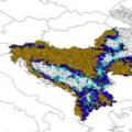
The pre-operational daily H35 effective snow-covered area product of H-SAF spatially spans the Northern Hemisphere and it is the successor of the operational Pan-European H12 product. Both products are at ~1 km resolution and developed through the H-SAF project of EUMETSAT by exploiting AVHRR channels. During the AS activity (i.e., H_AVS_18_03), an alternative machine learning-based approach is applied on H35 product to improve its accuracy. The new version of H35 product is realized through multivariate adaptive regression splines (MARS) algorithm. AVHRR reflectance data, as well as the well-known snow and vegetation indices (i.e., NDSI and NDVI), are used as predictors to generate the new MARS-based H35 product. The reference fractional snow-covered area (fSCA) maps are obtained from higher resolution Sentinel 2 imagery. Rigorous assessment on the final MARS-based H35 is performed over the Northern Hemisphere within a temporal domain from Nov 2018 to Nov 2019 by using i) Sentinel 2 derived reference fSCA maps, ii) ERA5-Land snow depth data, iii) MODIS MOD10A1 NDSI snow cover data, and iv) in-situ snow depth data. An additional visual assessment is also carried out by comparing MARS-H35/MODIS false-color and MARS-H35/Sentinel 2-derived reference fSCA image pairs over various geographic regions.
Snow plays an important role in the Earth energy exchange processes, and is a fundamental element of the water cycle. The use of satellites for snowfall monitoring and quantification and for retrieving snow cover properties and variability is necessary to globally quantify water resources. Recent studies have evidenced how space borne multi-channel microwave (MW) radiometer measurements respond to both snowfall and snow cover properties. Improvement in both monitoring of high latitude precipitation and in our understanding on microphysical and dynamical processes that influence high latitude precipitation patterns, intensity and type must be driven by concerted observations of active radars and passive microwave radiometers. This has been recently demonstrated through the development of machine learning-based algorithms for snowfall detection and retrieval, exploiting global observational datasets built from passive and active microwave space borne sensors. In this presentation the challenges and recent advancements in satellite-based snowfall quantification and global monitoring will be discussed. Moreover, retrieval strategies based on machine learning approaches that are being adopted within the EUMETSAT H SAF in view of the future EPS-SG mission, will be presented.
The development of precipitation retrieval techniques can now benefit from the availability of unique cloud and precipitation observations by the two space borne radars currently available: the Dualfrequency Precipitation Radar (DPR) on board the NASA/JAXA GPM Core Observatory, and the NASA CloudSat Cloud Profiling Radar (CPR). These two radars have demonstrated their complementarity in the monitoring of precipitation. While DPR has shown a high accuracy in the estimate of medium and intense precipitation regimes, CPR has proven to be very suitable for the retrieval of light rain and snowfall. Within the H SAF a new algorithm for the Micro-Wave Sounder (MWS) radiometer on board the EPS Second Generation satellites (MetOp-SG) has been developed. Different machine learning approaches were tested in order to select the most suitable for optimizing the performance of the algorithm for the detection (a classification problem) and estimate (a regression problem) of rainfall and snowfall.
The details concerning the coincidence datasets creation, the design of the ML modules and the algorithm input selection procedure will be presented, together with results of the algorithm's performance.
Session 6 - 27 January 2022
Over the past few years, there has been a rising in intense precipitation events, resulting in severe effects on people and infrastructures. To meet the challenge of analysing weather events comprehensively and globally, the use of information from satellite is playing an ever-increasing role in the field of meteorology. In this context, H SAF provides data sets and products for operational hydrological applications: an overview of SEVIRI-based products will be given: H60, H61, H63 and H90.
Their validation process and a direct inter-comparison between the same products with differentspatial coverage will be shown to demonstrate their extended spatial validity.
In recent years, in some areas over Europe, there has been an incidence of extreme weather events that have severely impacted people, structures, and infrastructure, causing damage and loss. The scientific literature indicates that the scenario is evolving and that there is an increasing number of severe weather events, which makes the use of as much data as possible particularly useful.
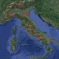
In this study, a comprehensive analysis of the July 2021 event that occurred over Como Lake (Italy) was performed, trying to provide a complete overview of all the data currently available for the analysis of this type of events.
This work shows recent advances in high resolution satellite products and their use in hydrological modelling. In a set of experiments, the distributed hydrological model Continuum is set up for the Po River Basin and forced by satellite precipitation and evaporation, while soil moisture and snow water equivalent are ingested through a data-assimilation scheme. All satellite products produced skilful estimates of river discharge. Satellite based evaporation and snow water equivalent marginally improve (by 2% and 4%) the mean Kling-Gupta efficiency at 27 river gauges. Interestingly, a model calibration heavily relying on satellite data provides skilful reconstruction of river discharges, paving the way to full satellite driven hydrological applications.
Developing satellite technology offers new products to simulate different hydrological processes. These products are invaluable in hydrological applications for mountainous areas where observation data is relatively limited. The H SAF project offers snow products over complex topographies.
The daily snow cover dataset derived by H SAF SE-E-SEVIRI (H10) is evaluated on the mountainous terrain of the Upper Euphrates Basin. Snow-covered area data is processed and analyzed. Snow depletion curves are extracted and used as basic forcing data in a conceptual model. The impact of the product is assessed by the model performance for runoff prediction results (KGE> 0.85) and also demonstrated in comparison to a well-known data set of MODIS.

Session 7 - 28 January 2022
The demonstration session gives an overview how to download, read and visualize H SAF soil moisture data using the Python programming language. Jupyter notebooks are used to present code examples, which are hosted at GitHub. H SAF Surface Soil Moisture (SSM) and Root-Zone Soil Moisture (RZSM) products are comprised of either Near Real-Time (NRT), Offline or Data Records (DR) products, which are freely available after user registration at the H SAF data portal. RZSM products are generated fromassimilating the ASCAT-derived surface SM in the ECMWF/H SAF land data assimilation system. Additionally, a hydrological exercise will highlight the added value of soil moisture satellite data for flood prediction. Soil moisture conditions have a great impact on the transformation of precipitation into runoff. A correct estimation of the initial soil moisture condition is a critical aspect for operational flood prediction. In the exercise we will test the sensitivity of flood response to initial soil moisture conditions using a simple hydrological model over an African Basin.
Recording S. Hahn, D. Fairbairn and S. Gabellani
The session includes a summary of H SAF precipitation products, with particular attention to the most recent products. The procedures to get access to the data, both for short range repository (last 60 days) and longtime archive data will be described. Moreover, the main data formats will be briefly presented, including the expected format changes in the near future. Python scripts and a Jupiter notebook developed for reading and visualization of precipitation data will be also presented.
Additionally, an example of Flood modelling with satellite rainfall data in Africa will be shown. Flood modelling over data scarce regions is challenging. Satellite rainfall data offer a viable tool to force hydrological models and provide discharge prediction at ungauged sites. However, being an indirect type of measurements, satellite rainfall observations can be subjected to significant bias and might be suboptimal over mountainous terrain. Here we show that model recalibration or bias correction even with a few rain gauges can provide boost hydrological model performance and thus make satellite rainfall data a valid solution to obtain discharge.
Recording C. Giorgi, D. Casella and C. Massari
H SAF snow cover and snow water equivalent products are comprised of either Near Real-Time (NRT), Offline or Climate Data Records (CDR), which are freely available at the H SAF data portal. Examples of downloading, reading, and displaying snow cover and snow water equivalent data in Python are presented.