Webcast


High resolution satellite Earth observations improve hydrological modeling in the Po River Basin, Italy
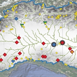
This work shows recent advances in high resolution satellite products and their use in hydrological modelling. In a set of experiments, the distributed hydrological model Continuum is set up for the Po River Basin and forced by satellite precipitation and evaporation, while soil moisture and snow water equivalent are ingested through a data-assimilation scheme. All satellite products produced skilful estimates of river discharge. Satellite based evaporation and snow water equivalent marginally improve (by 2% and 4%) the mean Kling-Gupta efficiency at 27 river gauges. Interestingly, a model calibration heavily relying on satellite data provides skilful reconstruction of river discharges, paving the way to full satellite driven hydrological applications.