Event Week on Precipitation 2020
From 14 to 18 December 2020 EuMeTrain in collaboration with H SAF organized an event week on precipitation. Precipitation is the most important variable in the Earth’s hydrological budget, being the major component of the water cycle. For this reason, the better understanding of the spatial and temporal distribution of precipitation, and its quantification is fundamental for any hydrological and climatological application. H SAF products and applications fit with the objectives of services, agencies, authorities and other initiatives which need information on water at the ground in order to monitor hazards and natural disasters such as flash floods, landslides and drought conditions, as well as to improve water management.
The event week was held using the Webex software and it was open to everyone who wanted to participate. The participants only had to register themselves, that way they received the links to access the sessions.
Session 1 - Afternoon 14 December 2020
H SAF products and applications fit with the objectives of services, agencies, authorities and other initiatives which need information on water at the ground in order to monitor hazards and natural disasters such as flash floods, landslides and drought conditions, as well as to improve water management. From 2005 H SAF started to provide remote sensing estimates of relevant hydrological parameters: instantaneous rain rate and cumulated rainfall, soil moisture at surface and in the root zone, snow cover and water equivalent. All products are available via EUMETSAT data delivery service (EUMETCast), or via ftp download; they are also published in H SAF website h-saf.eumetsat.int. The project involves experts from 12 national meteorological and hydrological European Institutes of Austria, Belgium, Bulgaria, Finland, France, Germany, Hungary, Italy, Poland, Romania, Slovakia and Turkey, and from ECMWF.
The goal of this seminar is to provide an overview of the state-of-the-art of remote sensing techniques for precipitation retrieval exploiting Low Earth Orbit (LEO) microwave (MW) and/or geostationary (GEO) visible/infrared (VIS/IR) observations, analyzing their potentials and limitations, and perspectives in view of future satellite missions. The first part will focus on the description of the main space borne observing systems with focus on passive MW sensors on board LEO satellites, and on the basic principles of precipitation retrieval from space. Particular emphasis has been given to the NASA/JAXA Global Precipitation Measurement (GPM) mission, and to its Core Observatory launched on February 27, 2014, equipped with the most advanced space borne microwave imager (the GMI) and the first space borne dual-frequency (Ku and Ka-band) precipitation radar, providing semi-global (between 65°S and 65°N) 3-D view and retrieval of the precipitation (solid and liquid). The second part will focus on the main precipitation retrieval techniques and in particular on those used in the EUMETSAT Hydrology Satellite Application Facility (H SAF) precipitation products. Finally, in the third part a few applications of satellite precipitation products will be shown to highlight scientific challenges and future perspectives to improve precipitation quantitative estimation from space.
Session 2 - Morning 15 December 2020
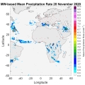
Passive microwave (PMW) radiometry is recognized as the most suitable for global precipitation monitoring and quantification. The H SAF precipitation products portfolio is being extended to provide Level 3 (gridded) PMW-based precipitation products to facilitate and promote the use of MW-based products for several applications. One of these products (labelled as P-IN-PWM, or H68) provides instantaneous precipitation rate estimates, based on calibrated and merged PMW Level 2 instantaneous precipitation rate products. H68 provides precipitation rate estimates every half hour, on a regular grid at 0.25°x0.25° resolution over the extended H SAF area (LAT 60°S – 75°N, LON 60°W – 60°E). The calibration is based on the precipitation estimates provided by the NASA Global Precipitation Measurement (GPM) DPR-GMI (Dual-frequency Radar and GPM Microwave Imager) combined product (2B-CMB). The H68 algorithm mainly consists of three modules (i.e. remapping module, adjustment module and merging module) that will be described. The other Level 3 PMW-based product that will be presented is P-DM-PMW (or H67), which provides as main output a 24 h mean precipitation rate based on the H68 product outputs. H67 provides data at the same spatial resolution as H68 at 00, 06, 12 and 18 UTC of each day for the previous 24 hours. Examples of H68 and H67 product outputs and applications will be provided.
Session 3 - Afternoon 15 December 2020
SM2RAIN is a novel algorithm that allows to estimate rainfall from a different perspective, using the soil a natural rain gauge. The algorithm has already been applied to several satellite soil moisture products both on a regional and global scale, providing high-quality rainfall data. Moreover, soil moisture-derived rainfall estimates have been found to be complementary to state-of-the-art top-down precipitation products. In this way, the integration of the two different approaches provides a more reliable rainfall product. Within H SAF, the SM2RAIN algorithm has been applied to Surface Soil Moisture (SSM) data obtained through Metop platforms. The SSM-derived rainfall data are then integrated with the Level 3 PMW H67 product. In this way, the integrated product P-AC-SM2RAIN (labeled as H64) can provide daily rainfall estimates with a spatial resolution of 0.25°, over the extended H SAF area (LAT 60°S – 75°N, LON 60°W – 60°E).
The H SAF products related to rainfall available to the public will be introduced, giving details about the data formats currently in use, with some indications about near future perspectives also. The procedure for registering to the web site, gaining access to the data, will be presented, showing how to download them from short term repository and how to request older ones. For each data format the procedure to extract data will be shown, in order to prepare them in a suitable way for MATLAB. In conclusion an example of how to plot data using MATLAB in the area of interest will be described.
Session 4 - Morning 16 December 2020
The main precipitation products developed worldwide are based on microwave (MW) radiometry Microwave (MW) radiation is the most effective for precipitation retrieval because of the direct interaction of radiation with the frozen and liquid hydrometeors within precipitating clouds as opposed to visible or infrared observations sensitive to the upper portion of the clouds. However, as microwave instruments are currently only available on-board satellites in Low Earth Orbit (LEO), they do not provide a continuous monitoring of rainfall over a given location. One methodology is to combine geostationary and low orbit satellite observations. This kind of multi-platform algorithm provides global precipitation estimation merging high quality, sparsely sampled data from low earth orbit satellites (e.g. Metop, NOAA series, DMSP, i.e. LEO/MS in general) with continuously sampled data from geostationary satellites (e.g. GEO/IR). The presentation will describe an example of such retrieval techniques used in HSAF and the future approach in combining such different sources of data.
The H SAF Precipitation Product Validation Group (PPVG) annually analyses all the operational precipitation products released by the consortium in order to check the quality and evaluate their performance over time. The Quality Assessment (Q.A.) service is carried out by comparison with precipitation data used as reference. The comparison over the Europe is performed with radar and rain gauge data belonging to eight European countries: Belgium, Bulgaria, Germany, Italy, Hungary, Poland, Slovakia and Turkey. The methodology used to evaluate the quality of precipitation products is common to all member states through the use of a same algorithm (named Unique Common Code). Over African areas the comparison is performed with respect to the Dual-frequency Precipitation Radar (DPR) products of the Global Precipitation Measurement (GPM). Data used, methodology applied, and results obtained will be presented.
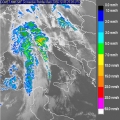
The Mediterranean Sea is recognized as a climatic hotspot, often affected by severe weather events that are becoming more and more frequent in the last decades. Extreme events originating over the Mediterranean Sea and hitting the coast can have tremendous impact both from hydrological point of view as well as in terms of human and economic losses. Among these events, increasing attention has been recently devoted to the so-called Mediterranean hurricanes (Medicanes) or tropical-like cyclones (TLCs) as well as to the severe precipitation events associated to atmospheric rivers. This presentation shows the potentials of H SAF products together with measurements collected by active and passive microwave sensors onboard LEO satellites for the characterization and monitoring of the precipitation associated to severe weather events during their different evolution phases.
Session 5 - Afternoon 16 December 2020
For proper usage of satellite products in meteorological applications it is necessary to take the set of skills which can be divided into technical, logistic and routine work with data, and final application of meteorological knowledge base by means of interpretation tools. Our lesson will provide step by step introduction to validation work with the H SAF precipitation products, introducing BUFR, GRIB and NETCFD decoding, reading and upscaling with the aim to put these various satellite products into common grid suitable for comparison against essential precipitation measurements considered as ground truth. Passing through the validation process and being aware of the accuracy of satellite products, we will show the applicability of these data using selected show cases over Central Europe. Case studies were prepared to demonstrate possibilities but also shortcomings of satellite data, which users need to take into account in practical usage. Because the proper preparation of satellite products is not important only for validation process itself, but also for practical applications, using show cases we will explain how to merge together various sources of precipitation information, e.g. irregular rain gauge point data, regular radar grid data, satellite scanned grids derived from microwave and infrared imagers. We will discuss the special treatment of continuous and discreet parameters like precipitation intensity or accumulated rain versus precipitation phase, quality index and surface type’s parameters to be up-scaled into common grid. Once up scaled data can be merged with the aim to obtain the most probable final values of instantaneous and accumulated precipitation fields. Final message of this training lesson addressed to meteorologists and hydrologists will be targeted to understanding that precipitation must be considered as stochastic parameter describing complex 3D processes in the atmosphere.
Many severe meteorological events occurred in Europe during the last decade and caused casualties and damages to the historical heritage and natural environment. The European Civil Protection agencies, supported by meteorological and hydrological institutes, aim to assess risk scenarios, to monitor and supervise events and risk levels, providing early warning to National and local authorities. Near real time accurate estimations of hydrological variables such as precipitation and soil moisture are invaluable for the hydrological risk evaluation, enable them to issue early warnings and plan for disaster relief at the local level.
Besides measurements of key hydrological variables by ground-based instruments, often affected by a limited spatial coverage, advanced satellite-based precipitation and soil moisture products developed within different international programs as H SAF, are available and accessible to users in near-real time. Severe meteorological events are selected in order to understand how the main satellite precipitation product characteristics, i.e. accuracy, spatial pattern and resolution, update frequency and latency, impact the efficiency of a hydro-meteorological early warning system at a local level in an operational framework.
Session 6 - Morning 17 December 2020
Flood modelling over data scarce regions is challenging. Satellite rainfall data offer a viable tool to force hydrological models and provide discharge prediction at ungauged sites. However, being an indirect type of measurements, satellite rainfall observations can be subjected to significant bias and might be suboptimal over mountainous terrain. Here we show that model recalibration or bias correction even with a few rain gauges can provide boost hydrological model performance and thus make satellite rainfall data a valid solution to obtain discharge.
In the presentation we will describe the theoretical background for using satellite rainfall products in flood prediction and provide some tips to enhance their performance in riverine flood modelling.
Session 7 - Afternoon 17 December 2020
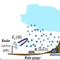
Multi-sensor data fusion prove that combining data from rain gauges and remote retrievals represents the best way to obtain an enhanced and more reliable evaluation of Quantitative Precipitation Estimation (QPE) that improve hydrological modelling for river discharge estimation. Although remote sensors produce an observation of precipitation subject to several sources of uncertainty, they capture the general covariance structure of the precipitation field. Thus, the information provided by remote sensors may be used to condition the information from rain gauges, which is limited in terms of spatial representativeness. In this way, an estimate of the rainfall field containing a more realistic spatial structure constrained to the rain gauges data can be produced. The presentation will describe the theoretical background and examples for merging satellite and gauge rainfall data for improving discharge modelling. A Modified Conditional Merging (MCM) approach, developed from the original Conditional Merging proposed by Sinclair and Pegram (2005), will be illustrated.
Session 8 - Morning 18 December 2020
Rainfall-induced landslides are one of the most frequent and dangerous natural hazards, occurring every year and causing fatalities and significant economic losses. Their impact is expected to increase in the next decades due to climate changing. In these premises, several countries have developed and implemented operational early warning systems for rainfall-induced landslides. The main tool for the prediction of landslides is represent by rainfall thresholds. Usually, these empirical thresholds use rainfall characteristics, i.e. intensity and duration, to define the conditions that likely triggered the landslide based on the analysis of historical events. Satellite rainfall data can be beneficial in this application as they provide information over large areas without the need of setting up and maintain a monitoring network. This presentation will describe the theoretical background and some examples for using satellite rainfall data for landslides prediction analysis.
Snow plays an important role in the Earth energy exchange processes, and is a fundamental element of the water cycle. The use of satellites for snowfall monitoring and quantification and for retrieving snow cover properties and variability is necessary to globally quantify water resources. Satellite-based snowfall detection and surface snowfall rate estimation are becoming an increasingly popular topic within both the hydrological scientific community and operational services. Recent studies have evidenced how space borne multi-channel microwave (MW) radiometer measurements respond to both snowfall and snow cover properties. In this presentation the challenges and recent advancements in satellite-based snowfall quantification and global monitoring will be discussed, and the retrieval strategies that are being adopted within the EUMETSAT H SAF to improve detection and quantification of snowfall, with particular focus on higher latitudes, will be presented.