Ocean and Sea Week 2011
From 31 October to 3 November 2011 an Event Week on Ocean and Sea was organised. The event week served as an exchange on the experience for the forecasting on shiproutes, but also advocate the benfits that the use of ASCAT data (Metop) as well as the altimetry data povided by Jason-2 can have to the operational forecaster.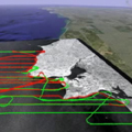
Session 1
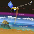
Sea surface temperature (SST), defined as one of the essential climate variables, has a key role in climate research and weather prediction by representing the boundary condition for both the ocean and the atmosphere. This presentation will show how the SST is retrieved from satellite observations and its main retrieval errors, the instruments and satellites used in its retrieval and the main SST applications. At the end, a brief overview of the future satellite SST-related missions will be given. (Igor Tomazic, Ruder Boskovic Institute)The second Presentation handles "Coastal upwelling and associated phenomena" in which a brief review of the Ekman layers is presented, followed by an overview of several phenomena resulting from wind driven coastal divergence. In addition to the presentation of general processes occurring in these areas, several aspects of the summer upwelling off Western Iberia are discussed (Paulo Oliveira, IPIMAR).
Recording Igor Tomazic | Recording Paulo Oliveira
Session 2
A presentation about Arctic sea ice drift and how to quantify this from satellite data. An introduction to 3 different sea ice drift data sets and their interaction with model wind is presented for selected parts of the Arctic ocean. Applications of ice drift data sets are listed. Finally, a glance on existing and future sea ice products from the "Ocean and Sea Ice - Satellite Application Facility" (Gorm Dybkjær, DMI / OSI-SAF).Second presentation is done by Anna-Helena Hultberg (SMHI). GAC-SMHI Weather Solutions is one of five biggest companies in the world making route recommendations for vessels worldwide. The customers are mainly big shipping companies which have different kind of vessels who behaves different in the sea. When making route recommendations we consider what kind of vessel it is and what kind of cargo they have. It is also important to know who their operator is and what demands they have. When a forecast is produced, parameters like wind, waves, swell, currents, icebergs, tropical cyclones etc. need to be looked after. This presentation will give you an idea about what GAC-SHMI does and how the forecasts are prodcued, including some recommendations.
Session 3
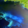
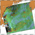
Visible channels for ocean applications using MERIS (Vanda Brotas, CO/FCUL)In this presentation André Valente (CCMMG), Azores University) talks about satellite images of phytoplankton chlorophyll in the North Atlantic. He introduces how phytoplankton chlorophyll is measured from space, describing the spatial and temporal patterns observed in the satellite images and identify the physical processes responsible for the observed variability."
Recording Vanda Brotas | Recording André Valente
Session 4
Presentation by Ad Stoffelen (KNMI / OSI-SAF) on ASCAT wind, with two subsequent parts of equal duration:- » High-resolution wind fields over sea and near the coasts; focus on marine nowcasting, oceanography and climatological applications.
- » Guidance on scatterometer data assimilation over sea; how can observed high-resolution information be incorporated in NWP?
Recording Stoffelen - lecture 1 | Recording Stoffelen - lecture 2
Session 5
Retrieval of wave parameters with Altimeter; Wind and wave from radar altimetry satellites: measurements and uses.(Vinca Rosmorduc CLS / AVISO)Radar altimetry satellites have been measuring the Earth’s ocean since 1991. Currently Jason-2, Envisat and Jason-1 are operational. If the main objective of those are the measurement of sea surface height, wind speed (modulus) and significant wave heights are very useful “bonuses” to this techniques. The presentation will explain how these quantities are retrieved from the altimeter measurements, and how they are used in meteorology, climatology and oceanography.
Sea surface height variation & mean sea level applications from radar altimetry (Vinca Rosmorduc CLS / AVISO)
Radar altimetry satellites have been measuring the whole Earth’s ocean since 1991. Currently Jason-2, Envisat and Jason-1 are operational. Their main objective is the measurement of sea surface height variations. With a twenty-years long time series, the possibilities for climate studies are wide. We will describe roughly the data processing and uses, but mostly insist on two different applications:
- » El Niño –Southern Oscillation
- » Global Mean Sea level
Recording Rosmorduc - lecture 1 | Recording Rosmorduc - lecture 2
Session 6
Presentation on SAR image analysis and on the interpretation of oceanic and atmospheric phenomena, with examples of signatures of downbursts, convective cells and sea/land breezes. Also, the retrieval of high resolution wind speed with SAR will be addressed (José da Silva, Univ. Porto)Recording da Silva