Webcast


SAR Image Analysis
Synthetic-aperture radar (SAR) is a form of radar whose defining characteristic is its use of relative motion between an antenna and its target region to provide distinctive long-term coherent-signal variations that are exploited to obtain finer spatial resolution than is possible with conventional beam-scanning means. It originated as an advanced form of side-looking airborne radar (SLAR).
SAR is usually implemented by mounting, on a moving platform such as an aircraft or spacecraft, a single beam-forming antenna from which a target scene is repeatedly illuminated with pulses of radio waves at wavelengths anywhere from a meter down to millimeters. The many echo waveforms received successively at the different antenna positions are coherently detected and stored and then post-processed together to resolve elements in an image of the target region.
Current airborne systems provide resolutions to about 10 cm, ultra-wideband systems provide resolutions of a few millimeters, and experimental terahertz SAR has provided sub-millimeter resolution in the laboratory.
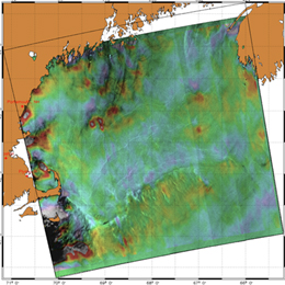
SAR images have wide applications in remote sensing and mapping of the surfaces. In this presentation the applications for monitoring the ocean surfaces are discussed.
![]() Go to Webcast...
Go to Webcast...
![]() Powerpoint...
Powerpoint...
Filed under Keywords:
SAR, Radar, Ocean, Oil, Slick