Webcast
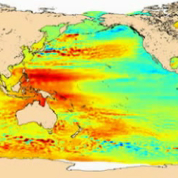


Sea Surface Height Variation
Radar altimetry satellites have been measuring the whole Earth’s ocean since 1991. Currently Jason-2, Envisat and Jason-1 are operational. Their main objective is the measurement of sea surface height variations. With a twenty-years long time series, the possibilities for climate studies are wide. We will describe roughly the data processing and uses, but mostly insist on two different applications:
» El Niño –Southern Oscillation
» Global Mean Sea level
![]() Go to Webcast...
Go to Webcast...
![]() Powerpoint...
Powerpoint...
Filed under Keywords:
Ocean, Waves, Altimetry, Radar, Aviso