Webcast


Fundamentals of satellite precipitation estimation
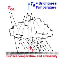
The estimation of precipitation from space was attempted almost at the beginning of the satellite meteorology era by establishing a somewhat loose link between visible and infrared imagery of cloud tops and precipitation intensity at the ground. Since the early days estimation methods have qualitatively and quantitatively evolved with the advent of passive microwave sensors first and precipitation and cloud radars more recently. The purpose of the lecture is to provide a necessarily brief overview of the basic physical principles underlying satellite precipitation estimation methods trying to make the audience aware of what the sensors actually “measure” (radiation properties) and how these measurements are converted into precipitation intensity. All the methods, either based on “passive” or “active” sensing, are necessarily indirect and thus a clear understanding of the physics of radiation and of cloud hydrometeors is needed for the correct use of the products. In fact, such understanding helps in identifying the limitations of the existing precipitation products, which are too often used improperly or taken for granted. The lecture will try to pave the way to the in depth lectures of the other instructors on more specific topics of the discipline.
Filed under Keywords:
precipitation, satellites, products, intensity, physical principles