Webcast

Observing Precipitation with Radars in Space
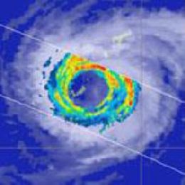
Radars provide the most direct means of remotely measuring precipitation over large areas. The value of ground-based radars for indicating the location and intensity of rainfall was recognized shortly after the first surveillance radars were developed during World War II. Since then radar networks have been widely used to estimate precipitation accumulations, track storms, and provide valuable information to the public. However, vast areas of the Earth including oceanic, mountainous, and densely forested regions are largely inaccessible to ground-based instruments. As a result, much of our knowledge of precipitation in such areas derives from passive satellite measurements that can suffer from uncertainties owing to the indirect relationship between radiation measured at the satellite and rainfall at the surface. Satellite precipitation radars offer some of the benefits of their ground-based counterparts with the enhanced coverage afforded by orbiting the Earth. To date three such radars have been launched providing a new perspective of global precipitation from tropical rainfall to polar snows that complements the longer-term record provided by passive instruments. This lecture will describe the physical principles used to relate the reflectivities measured by these radars to precipitation intensity. We will examine the main features of the associated precipitation retrieval algorithms and some of the important factors that need to be considered will be highlighted through illustrative examples. We will conclude by contrasting the strengths and limitations of satellite radars against passive satellite sensors and ground-based radar systems.
Filed under Keywords:
Radar, precipitation, tropical rainfall, snow

