Snow Event Week 2021
In the week from 8 to 12 February 2021, EuMeTrain organized an Event Week on Snow. Within this week several presentations took place online and covered many topics about snow and ice. The presentations held were about climate, case studies, modelling, snow in aviation, snow and radar, satellite facillities, winter sport aspects and many more.
Session 1 - 8 February 2021
Forecasting deep-moist convection and lightning in winter is challenging, partly because it occurs outside the typical season and partly because it forms in the environments characterized by marginal buoyancy. Despite weak CAPE, winter time convective storms often pose a considerable severe weather risk given their frequent collocation with strong vertical wind shear. In this presentation we explore different regimes under which ingredients come together and create marginal CAPE setups typical of winter. These include synoptically strongly-forced situations, elevated storms and the lake-effect over the European seas.
Automated observations of solid precipitation and snow cover are still one of the most difficult meteorological measurements to make with any known level of uncertainty. Many recommendations on best practices for measuring solid precipitation and snow cover emerged during and following the international Solid Precipitation Inter-Comparison Experiment (SPICE), including the development and application of transfer functions for adjusting precipitation gauge under-catch and techniques for minimizing errors in automated snow depth measurements. Following SPICE, work has continued on assessing and utilizing emerging technologies, such as optical and radar based present weather detectors, for improving the in situ measurement of solid precipitation. Furthermore, more effort is required to facilitate the transfer of techniques and best practices from research to application in operational networks.
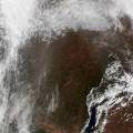
Session 2 - 9 February 2021
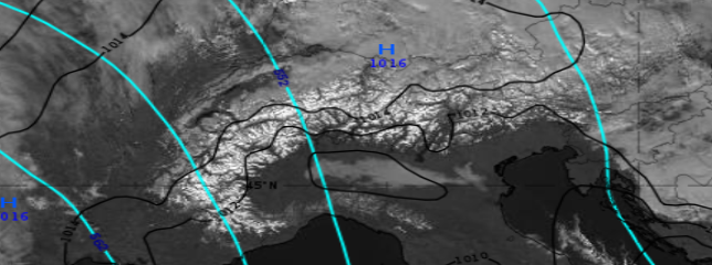
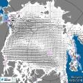
Single channels and RGB types will be discussed and compared from the snow detection point of view: how effectively they can be used for this purpose, which benefits and limitations they have. Physical background will be discussed and several examples will be shown.
Ideally an RGB type is usable for snow detection if the snow-covered cloud-free surface has good colour contrast against both now-free surface and clouds. Practically, one problem may cause difficulty: ice clouds and snowy land often appear similarly. Not surprising: their physical properties are similar as both consist of ice crystals. The presentation discusses which RGB types show snow and ice clouds less similarly. Forecasters usually look at animations, this also helps to distinguish snow covered area from moving ice clouds.
Detection of snow, but also its classification (depth, crystal size, age) depends mostly on the spectral and spatial resolution of geostationary satellites. Having better spatial resolution and more spectral channels, Meteosat Third Generation satellites (MTG) will be able to see snow better and tell more about its flavours, especially in the visible and near-IR spectral regions. Join if you are interested to know how the snow detection will be done with MTG and what is "the colour of the snow" with future data.
EUMETSAT is releasing new pilot services which will provide new data access capabilities. New services include the EUMETSAT Data Store and EUMETSAT Data Tailor, as well as improvements to the EUMETView. In partnership with ECMWF, EUMETSAT is also offering hosted processing services through the European Weather Cloud. The necessary short information required to access and use these services will be provided during the presentation.
Session 3 - 9 February 2021
Weather radar data offers high spatial and temporal structures of three dimensional precipitation fields and can be well used for warning and nowcasting of adverse winter weather. Radar reflectivity, Doppler velocity products and polarized radar moments de liver insights into cloud microphysics and dynamical properties, such as the discrimination between different types of hydrometeors, quantitative precipitation estimation, icing conditions or areas of strong shear. Beside aeronautical nowcasting application, also the limitations of using weather radar in a cold winter weather environment will be addressed.
The weather still has a major impact on aviation today. Weather forecasts in aviation not only support safety, but also provide important input on the subject of economical air traffic. As part of this presentation, I would like to give a rough overview of how air traffic works in the cold season. I will speak about de- and anti-icing of aircraft and the snow removal in the airside area. Finally, I will show which meteorological products are created to support safe and economical air traffic.
Session 4 - 10 February 2021
The sea ice products from the EUMETSAT Ocean and Sea Ice Satellite Application Facility are widely used. In this presentation the sea ice products will be presented and examples of use in operational numerical weather and ocean modelling will be given.
H SAF satellite snow extent products can be used for many meteorological and hydrological applications, for example as inputs for weather models. What are these products? How good are they? Especially, MSG/SEVIRI (H31) and Metop/AVHRR (H32) products are described with examples and validation results.
The first step of the cloud detection during day, is the snow/ice detection on the ground or at the sea surface. The talk will give details of the flag snow/ice in the cloud mask and in the cloud type. The algorithm will then be presented and illustrated by a recent example. The importance of this snow/ice detection will be pointed out for a good cloud detection. Finally, we will explain the limitations of this flag snow/ice.
Session 5 - 10 February 2021
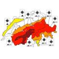
In mountain regions in winter, snow avalanches are relatively frequent and widespread. Compared to other gravitational mass movements, such as landslides or debris flows, snow avalanches occur much more frequently and over a broader geographical area. This has enabled avalanche forecasters to gain practical experience and develop rule-based empirical methods to manage the danger of this ubiquitous natural hazard. However, the ability to forecast avalanches, i.e. predicting snow instability in space and time, is limited by current experience-based forecasting practices. Improvements in terms of spatial and temporal resolution can only be made through model development. In this talk, I will give an overview of recent efforts at the WSL Institute for Snow and Avalanche Research SLF in Davos, Switzerland, to develop models for avalanche forecasting - from mechanical models to better understand the fundamental processes leading to avalanche release to snow cover models to provide real-time information on snow stratigraphy and stability.
While the usage of models for weather forecasting has been long established, the application of snow cover models for operational avalanche warning purposes is still quite novel. In Austria, the national weather service, ZAMG, develops model-based tools for operational avalanche warning services and local avalanche commissions. In particular, a model-chain consisting of a snow cover model and an ensemble of weather models to operationally assess and predict avalanche hazard in a local context is currently developed. The model-chain provides regional avalanche forecasters and local avalanche commissions with continuous, detailed information about the snow cover from the near-past to the nearfuture. This is to enable early warning of exceptional snow cover situations. In this talk we will give an overview on model-based tools for avalanche services and present the local avalanche prediction model and preliminary results of a first test season in more detail.
Session 6 - 11 February 2021
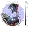
The presentation shows the basic approach to apply passive microwave radiometer data for retrieval of terrestrial snow water equivalent. It describes the GlobSnowmethodology to combine satellite-based radiometer data with ground-based snow depth observations and a bias-correction approach to improve the satellite-based retrievals. It also presents the historical satellite-based reconstruction of Northern Hemisphere snow mass, from 1980 to present day (published on Nature, Pulliainen et al. 2020). Pulliainen, J., Luojus, K., Derksen, C. et al. Patterns and trends of Northern Hemisphe re snow mass from 1980 to 2018. Nature 581, 294–298 (2020). https://doi.org/10.1038/s41586-020-2258-0
The presence of snow cover on the land surface is closely linked to the prevailing climate. Moreover, by modulating surface energy fluxes snow cover is interactively linked to the atmosphere and constitutes an important component of global and regional climate systems. Available observations show a retreat of snow cover on hemispheric scales as a response to global warming, and climate projections consistently indicate a further decrease. Focusing on Europe and especially on the European Alps, this contribution summarizes current research on the fate of surface snow cover and its implications.
At the beginning, the economic interrelationships of winter tourism in the Alpine region, Austria and finally Tyrol are highlighted. The dependence of value creation on a reliable snow situation in winter therefore forces snow management, the economic and above all ecological tasks of which will be presented. The participants will get to know the essential problems and the existing approaches to solving them.
Session 7 - 11 February 2021
Snowy winters lead to heavy snow loads on buildings and constructions. Surprisingly often, the snow load assessment basis of international and national standards are regionally reached or exceeded. Damages or even collapses do occur, cause expenses and threaten human lives. However, extreme snow loads only rarely are considered as natural hazards. This talk puts heavily burdened roofs in the spotlight by presenting recent efforts in updating the Austrian snow load standard and showing an actual example of snow load monitoring and hazard management.
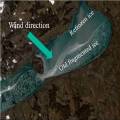
Lake Balaton is the largest lake in the Carpathian Basin. The shallow lake (with 3.5 m mean depth) responds to the weather rapidly: in hot summers the water temperature increases above 25 °C, and at colder winters thick ice (20-40 cm) appears on the lake surface. The formation of the ice depends very much on the weather. Glassy ice forms when after a cold front passage in the night the wind and waves calm down and the previously mixed up and supercooled water freezes rapidly. During longer cold and windy weather period, ice appears in forms of ice floes, frozen to each other. This presentation tries to give an overview of the metamorphosis and special dynamic of the Balaton ice.
Session 8 - 12 February 2021
The report presents the results of studies of the characteristics of snow cover for the territories of Western and Eastern Siberia. The research period is from 1976 to 2020.
The report describes the duration of persistent snow cover, the time intervals between the first snowfall and stable snow cover and between the destruction and disappearance, a number of characteristics of the snow cover: duration of occurrence, thickness and water content.
Meteorologists and weather technicans from the German Meteorological Service (DWD) attended the entire MOSAiC expedition, the largest-scale Central Arctic research expedition of all time. They were responsible for permanent weather observations and daily meteorological forecasts for scientists, ship master and officers, as well as helicopter pilots. Our presentation will report about personal experiences of a meteorologist on board of the research icebreaker POLARSTERN, with the focus on the daily work of the forecaster and the importance of using satellite images in Polar Regions.