LSA-SAF Week 2011
Land Surface Applications (LSA-SAF) presents itself in an event week in which presenters explain the applications, the validation and the access to the various products they develop. The event week consists of several sessions given by different institutes represented in the SAF Météo-France (MF), Instituto de Meteorologia (IM), Universidade de Lisboa (UL) and the Royal Meteorological Institute of Belgium (RMI)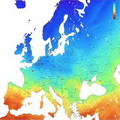
Session 1
Land surface albedo quantifies the fraction of energy reflected by the surface of the Earth. As a corollary it then also determines the fraction of energy absorbed by the surface and transformed into heat or latent energy. Land surface albedo therefore is a key variable for characterising the energy balance in the coupled surface-atmosphere system and constitutes an indispensable input quantity for soil-vegetation-atmosphere transfer models. On the other hand, the down-welling surface short-wave radiation flux (DSSF) refers to the radiative energy in the wavelength interval [0.3µm, 4.0µm] reaching the Earth's surface per time and surface unit. It essentially depends on the solar zenith angle, on cloud coverage, and to a lesser extent on atmospheric absorption and surface albedo.This presentation is devoted to an introduction of method retrievals for surface albedo and DSSF products that are implemented in framework of the LSA SAF in using MSG /SEVIRI observations. A second presentation will detail the validation exercise of these two LSA SAF operational products, which is based on inter-comparison with other satellite products, in situ measurements and outputs from NWP models.
Recording Jean-Louis Ruojean
Session 2
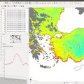
This one hour presentation takes focus on the characteristics of the product files that are produced and distributed by LSA SAF. The structure of the files is explained and freeware tools are presented. All the relevant informations are given for the obtaining LSA-SAF products. More general product informations are given for documentation and file structure of data. Also, this session is explaining how to use Quick visualization by means of HDFView, GIS tools for visualization and analysis (Quantum GIS, GRASS GIS and ILWIS) and tool for georeferencing LSA SAF products. At the end of presentation there are words about how to use Phyton scripting for building custom scripts or programs for accessing and manipulating Land SAF data.Recording Ricardo Silva
Session 3
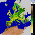
The current presentation gives an overview on the use of satellite data, particularly that from Meteorological satellites, for monitoring vegetation cover and properties. Some basic physical principles are first presented and then some RGB images are shown, allowing to identify different features in the surface of the earth. Further information on vegetation is given by a wide range of empirical indices, from which one of the most used is the NDVI. There are howeversome disadvantages on using such vegetation indices. Other parameters more related to vegetation properties and health than this conventional empirical indices are available from the LSA SAF. These are the fractional Vegetation Cover (FVC), the Leaf Area Index (LAI) and the Fraction of Absorbed Photossintetically ActiveRadiation (fAPAR). The algorithm rationale for deriving such parameters is explained and some validation results are presented. Finally the use of these products in several applications is shown.Recording Carla Barroso
Session 4
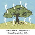
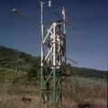
Evapotranspiration is a parameter closely related to vegetation state and stress. This session will show how this quantity is obtained within the LSA SAF. Evapotranspiration is estimated using a land surface model forced with radiation and vegetation variables obtained from SEVIRI measurements. Very interesting Resistance scheme of this model is nicely explained using deviding image pixels into 'tiles' of homogeneous vegetation types. Input and output of this model is also mentioned. Presentation is showing validation and incomparison of results together with possible applications of it.Recording Nicola Ghilain and Alirio Alboreda
Session 5
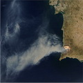
This session will analyse weather patterns that favour wild fires, as well as other risk factors, such as topography and existing fuel (biomass). Such factors are combined together to originate fire risk indexes. One of such indexes is derived from SEVIRI and ECMWF forecasts and is being routinely generated by LSA SAF. This product, called Fire Risk Mapping (FRM) provides, on a daily basis, forecasts of fire risk over Mediterranean Europe up to three days in advance.The second part of the presentation will be dedicated to LSA SAF products related to near real time monitoring of wild fires, namely Fire Detection and Monitoring, and the Fire Radiative Power. The latter is directly related to the rate of biomass combustion and therefore allows the estimation of carbon emissions from the vegetation fires. Unfortunately there is no recording of this lecture.
Powerpoint DaCamara
Session 6
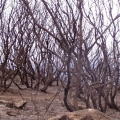
This session is continuation of fire discussion, started with session 5. Discussion is held on various techniques of mapping burnt areas from remotely sensed data, describing the main sources of errors and strategies to overcome them. Focus of first part of this session is so-called Fire Detection and Monitoring (FD&M) product, which provides continous monitoring of fire activity over Africa and Europe. This product relies on Fire Detection Algorithm called FiDAlgo (based on so-called contextual algorithms), is an operational procedure that allows active fire detection in near-real-time and is based on information from Meteosat-8, i.e. SEVIRI instrument.The second part will present applications to the analysis of burnt scars and vegetation recovery, with case studies for the Iberian Peninsula. Operational product for tracking burnt areas LSA-SAF still doesn't have, but presentation gives perspective of rising such. Very simple model for post-fire vegeration recovery is presented and are shown correlations between post fire vegetation recovery dynamics and severity of fire damage.
Recording DaCamara
Session 7
The first block of this session presents the physical principles and algorithms underlying the retrieval of Land Surface Temperature (LST) and emissivity from satellite observations. Both geostationary, GEO (MSG) and low-orbit, LEO (Metop) satellite advantages and disadvantages are discussed. Emphasis of the presentation is on the methodologies used by LSA SAF for deriving these LST and emissivity products. The presentation also gives focus on the assessment of the uncertainty associated to the retrievals and respective validation is given.Second part of this presentation is dedicated to algorithms used in the estimation of one of the components of the surface radiation budget - Down-welling Surface Long-wave Fluxes, i.e. DSLF. This product is derived from MSG SEVIRI instrument withing LSA SAF. Probelmatics of firs 100m atmosphere long-wave radiantion is also well discussed. Presented are examples and validation results that put into evidence the strengths and caveats of this product. Current Status & further developments (CDOP2) will follow.
Recording Isabel Trigo
Session 8
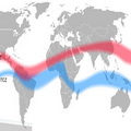
This presentation gives various applications of LSA SAF radiation products that we can find in four production areas for MSG satellite; Europe, Northern Africa, Southern Africa and Suthern America. Firstly, variability (both seasonal and spatial) that we can find in albedo fields are discussed together with signatures, or features you can look for in LST fields. Relations between LST and vegetations, which comes from the fact that vegetation is controling temperature by means of evepotranspiration are also shown here. Another application of radiation product is diagnose of various models via land surface temetarure. At the end of presentation there are some words about long-wave and shot wave surface radiation budget, which are strongly influenced by clouds at seasonal scale.Recording Isabel Trigo
Session 9
This session is wrap up of all applications of LSA SAF products, feedback from users (anuall revision by technicaland scientific rewiev panels), lessons learned and roadmap for the next phase (2012-2017).Presentation is divided into three parts; general description of LSA SAF; applications of LSA SAF products ; and the way foward, i.e. perspectives of LSA SAF.
Recording Pedro Viterbo