H-SAF - Event Week 2019

EUMeTrain organised an event week on Soil Moisture products of H-SAF from 4th to 8th November 2019. During this week we focused on topics such as demonstration of H-SAF Soil Moisture products, Flood prediction and Soil Moisture for drought monitoring. The event week provided an interesting insight of the H-SAF Soil Moisture products from a scientific and application-oriented point of view. The lectures were broadcasted using the WebEx Training Center platform. Each session comprised of 1 or 2 presentations. The duration of a complete session was around 1 hour.
Session 1: Introduction
H-SAF started in 2005 and aims to provide remote sensing estimates of relevant hydrological parameters: instantaneous rain rate and cumulated
rainfall, soil moisture at surface and in the root zone, snow cover and water equivalent. The project involves experts from 12 national
meteorological and hydrological European Institutes of Austria, Belgium, Bulgaria, Finland, France, Germany, Hungary, Italy, Poland, Romania,
Slovakia and Turkey, and from ECMWF.
The H-SAF main objectives are: to provide new satellite-derived products (precipitation, snow parameters and soil moisture) from existing and
future satellites with sufficient time and space resolution to satisfy the needs of operational hydrology, and to perform independent validation in
order to assess the usefulness of the new products for fighting against floods, landslides, avalanches, and evaluating water resources.
In situ and satellite-derived soil moisture observations are needed to better understand and simulate land surface processes. This has been the subject of active research for more than two decades. The transfer to operations in weather forecast, hydrometeorological, and drought monitoring applications also implies the integration of satellite-derived observations into models. Examples of the use of soil moisture observations, simulations, and data assimilation are presented.
Session 2: Surface Soil Moisture Products
H-SAF Surface Soil Moisture (SSM) products are derived from the Advanced Scatterometer (ASCAT) on-board the series of Metop satellites operating in space since more than 14 years. The SSM retrieval is based on a semi-empirical change detection method developed by TU Wien, which exploits the multi-incidence angle measurement capability of the fan-beam scatterometer ASCAT. While ASCAT Near Real-Time SSM products are most current and well suited for Near Weather Prediction (NWP), ASCAT Climate Data Record (CDR) products ensure long-term consistency and stability. This presentation will discuss the algorithmic background of the ASCAT SSM retrieval and describe the properties and characteristics of currently available ASCAT SSM products.
H-SAF Surface Soil Moisture (SSM) products that are comprised of Near Real-Time (NRT) SSM products and Climate Data Record (CDR) products are freely available at the H SAF data portal. Examples of downloading, reading and displaying SSM data in Python are presented. Ascat python software package that reads and converts data derived from the Advanced Scatterometer (ASCAT) on-board the series of Metop satellites and pytesmo python library that can be used for reading, comparison and validation of geospatial time series soil moisture datasets are introduced.
Session 3: Root Zone Soil Moisture
ECMWF provides the core root-zone soil moisture (SM) products for H-SAF through an Extended Kalman filter assimilation system, running independently of the NWP system. Space borne scatterometer-derived surface SM observations are assimilated into the root-zone (0-1 m) SM of the H-TESSEL land surface model. In this presentation, the theory behind the near-real-time and data record products is discussed.
H-SAF root-zone soil moisture products are freely available online. They are currently stored in daily files on a reduced Gaussian grid in GRIB binary format, which increases storage efficiency. Examples of downloading, converting the format to regular netCDF files and visualizing the data in Python are presented. The new metview-python package is also introduced, allowing direct applications in GRIB format.
Session 4: Time Series and Spatial Pattern
Soil Moisture is a crucial variable in hydrological applications. It can be measured and estimates in different way and along different spatial and temporal scale. The presentation describes how soil moisture estimated trough satellite can be compared and validated with other sources of information; theoretical basis and practical example will be showed.
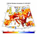
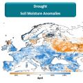
Session 5: Drought Monitoring
Satellite soil moisture (SM) products are highly suitable for monitoring agricultural drought. As satellite SM products cover long time periods and are available for large regions, the spatial and temporal analysis of drought conditions can be performed. The presentation will describe the theoretical background for performing drought analysis with satellite SM data, and will show some examples for the actual use of the data in identifying drought conditions in some regions worldwide.
Session 6: Flood Prediction
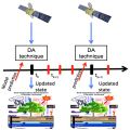
The reliable estimation of hydrological variables in space and time is of fundamental importance in hydrology to improve the flood predictions and hydrological cycle description. Nowadays remotely sensed data can offer a chance to improve hydrological models especially in environments with scarce ground-based data. The presentation describes how satellite soil moisture can be used in hydrological modelling trough data assimilation.
Session 7: Flood Prediction
Satellite soil moisture (SM) products have been largely used for flood prediction. The knowledge of initial soil moisture conditions before a rainfall event is critical to determine the magnitude of a flood event. The presentation will describe the theoretical background for using satellite SM products in flood prediction, and will show examples for understanding the critical role of initial soil moisture for predicting floods.
Session 8: Hazard Assessment
Many severe meteorological events occurred in Europe during the last decade and caused casualties and damages to the historical heritage and
natural environment. Protection of civilians and safeguard of the territory are the kay mandates of a civil Protection (CP) agency. This is
achieved through activities that mitigate hydro-meteorological risks, such as flooding and droughts. European CP agencies, supported by
meteorological and hydrological institutes, aim to assess risk scenarios, to monitor and supervise events and risk levels, providing early
warning to National and local authorities.
Near real time accurate estimations of hydrological variables such as precipitation and soil moisture are invaluable to the CP agencies,
enable them to issue early warnings and plan for disaster relief at the local level.
Besides measurements of key hydrological variables by ground-based instruments, often affected by a limited spatial coverage, advanced
satellite-based precipitation and soil moisture products developed within different international programs as H SAF, are available and accessible
to users in near-real time.
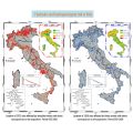
In this study, recent severe meteorological events are selected in order to understand how the main satellite product characteristics, i.e.
accuracy, spatial pattern and resolution, update frequency and latency, impact the efficiency of a hydro-meteorological early warning system at a
local level in an operational framework.
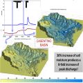
Umbria Region Civil Protection Early Warning center (Central Italy) is in charge of alerting and monitoring critical events for Civil Protection purposes (mainly landslides and floods). In last ten years the office has used, in cooperation with national research institutes, satellite data to improve modeling/forecasting tools performances, monitoring activities about possible impacts of severe rainfall events able to trigger floods and landslides at regional scale. In fact, the estimation of the soil water content has proved to be a key parameter for better forecast models implementation both for landslide than for flood risk issues.