Environment Event Week 2016

From 11 to 15 April 2016 EUMeTrain was organising an event week with topics related to environmental meteorology. The
focus has been on measurements of atmospheric constituents such as aerosols, dust and trace gases measured from space. But it also treated other
ecological aspects of meteorology such as fires and soil moisture monitoring from space.
Each session comprised 1 or 2 presentations. The duration of a session will be around 1 hour.
Session 1: Aerosols
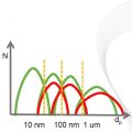
The GRASP (Generalized Retrieval of Aerosol and Surface Properties) algorithm has been developed for enhanced characterization of the properties of both aerosol and land surface from diverse remote sensing observations. The overall concept of the algorithm is described by Dubovik et al. (2014), while the detailed are given in the paper is by Dubovik et al. (2011). The algorithm is based on highly advanced statistically optimized fitting implemented as Multi-Term Least Square minimization (Dubovik, 2004) and deduces nearly 50 unknowns for each observed site. The algorithm derives a set of aerosol parameters similar to that derived by AERONET including detailed particle size distribution, the spectral dependence on the complex index of refraction and the fraction of non-spherical particles. The algorithm uses detailed aerosol and surface models and fully accounts for all multiple interactions of scattered solar light with aerosol, gases and the underlying surface. All calculations are done on-line without using traditional look-up tables. In addition, the algorithm can use the new multi-pixel concept - a simultaneous fitting of a large group of pixels with additional constraints limiting the time variability of surface properties and spatial variability of aerosol properties. This principle provides a possibility to improve retrieval for multiple observations even if the observations are not exactly co-incident or co-located. Significant efforts have been spent for optimization and speedup of the GRASP computer routine and retrievals from satellite observations. For example, the routine has been adapted for running at GPGPUs accelerators. GRASP inherits many aspects used in AERONET retrieval. At first GRASP has been developed for POLDER/PARASOL multi-viewing imager and later adapted to a number of other satellite sensors such as METEOSAT/MERIS at polar-orbiting platform and COCI/GOMS geostationary observations. It can be equally applied to ground-based AERONET and lidar observations. The results of numerical tests and results of applications to real data will be presented.
Recording Oleg DUBOVIK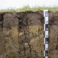
Session 2: Soil moisture from ASCAT
Droughts are one of the most severe natural hazards with regard to affected people, spatio-temporal extension and economic losses. At the same
time, population growth is expected to put global agricultural production under increasing pressure. Thus, drought monitoring and forecasting
systems would be essential for large parts of the globe, and satellites are a valuable data source to establish such monitoring systems.
The presentation will give examples on the relevant parameters measured by satellites, whereas the focus will be on soil moisture. Furthermore, the
combination of satellite measurements and model forecasts will be described to point out the state-of-the-art possibilities in forecasting drought
events. Examples from an existing system will be presented for the region of Eastern Africa.
Session 3: Aerosols and trace gases
The aerosols have recently been incorporated into increasing number of global climate models. Aerosol models in global climate models are validated using variety of ground-based observations and satellite retrievals. Both data have their own advantages and disadvantages. For example, in-situ observations of particle size and composition give exact information on the aerosol distribution for small regions on the ground while satellite retrievals give a broader view on the global distribution of aerosols. In both cases the rather coarse spatial and temporal resolution of the global models increase the difficulty of using these data for their validation. I will demonstrate the limitations of the satellite retrievals and in-situ observations when comparing with models and demonstrate how, for example, collocation of the data can help to improve the match between models and observations.
Recording Tommi BERGMANThe monitoring of trace-gases, pollution and aerosols is important both for the quality of current and future weather forecast model output, as well as for the direct monitoring of aircraft safety, pollution levels, and other health related issues. Satellite instruments on-board EUMETSATs operational platforms, like on the Low-Earth Orbit (LEO) Metop platform, or the Geostationary Orbit (GEO) MSG platform, and their future successors EPS-SG and MTG, provide unique long-term monitoring capabilities of atmospheric composition addressing many of these issues. We will introduce the capabilities of instruments on these platform to retrieve trace-gases from ozone to nitrogen dioxide, CO and of greenhouse gases like methane, as well as their capability to retrieve aerosol optical and microphysical properties including volcanic ash. We will provide examples on how these products are used in current and future versions of numerical forecast models which include atmospheric chemistry processes, like in the model provided by the Copernicus Atmospheric Monitoring Service (CAMS).
Recording Rüdiger LANG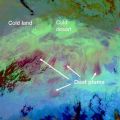
Session 4: Dust and fires
Dust sources are mostly located in remote areas and satellite observations are very suitable for their identification. Different methods inferring active dust sources have been developed in the recent past, which roughly can be separated into direct (e.g., back-tracking of dust plumes to their place of origin) and indirect methods (e.g., frequency of high atmospheric dust loading). Thereby, the accuracy of the identification methods varies with the temporal and spatial resolutions and the ambiguities of the satellite dust retrieval used. In concert with satellite-based dust source characterization, model simulations allow for a holistic assessment on dust sources and their controlling mechanism - ultimately providing insight into the multifaceted nature of the atmospheric dust life-cycle.
Recording Kerstin SCHEPANSKIApart from the central desert areas, the Australian landscape, from the tropics of Far North Queensland to the southern tip of Tasmania has climatic conditions and vegetation which are conducive to wildfires throughout the year. The most volatile of these areas being the south eastern parts of Australia which includes the states of South Australia, Victoria, New South Wales and Tasmania. Australia has large tracts of wilderness which can only be monitored by aircraft and satellite and as such, remote sensing for bushfires within the landscape is virtually mandatory throughout the dry season in the tropics and the summer periods for the southern states. This talk looks at some of the ways that Satellite Remote Sensing has assisted emergency managers for preparedness, response and recovery, the three most important factors for any emergency operation.
Recording Mike WILLMOTT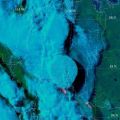
Session 5: PyroCumulonimbus and atmospheric pollution
Pyroconvection is not a new concept. However, the idea that pyroconvection can be explosive enough to inject a smoke plume into the stratosphere
that pollutes hemispherically, goes against the grain of textbook atmospheric physics. Since the discovery of forest fire smoke in the
stratosphere, skepticism has given way to acceptance, understanding, excitement, and wonder. That is because pyrocumulonimbus (pyroCb for short)
research continues to make more discoveries, involve growing collaborations, and invite new questions.
This presentation will be an overview of pyroCb research. It will focus on observations from satellite sensors. Emphasis will be on platforms such
as MODIS, AVHRR, GOES, TOMS, OMI, GOME 2, and CALIPSO. Also to be explored will be the curious historic connection between pyroCb and volcanic
eruptions.
Measurements Of Pollution In The Troposphere (MOPITT) on the NASA Terra spacecraft has been measuring the global atmospheric abundance of carbon monoxide (CO) since March 2000. Carbon Monoxide is mainly produced by incomplete combustion from both natural fires and anthropogenic activities and is also a product of chemical reactions with other air pollutants. These pollution sources have a large effect on both local and downwind air quality, as well as climate change. We will show how satellite measurements of carbon monoxide are used to understand how pollution is emitted and transported globally, from large scale fires to urban sources.
Recording Helen WORDEN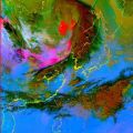
Session 6: Dust and fire forecasting
In this presentation, we will show the result of detection of dust using COMS data. Several Asian dust cases will be presented and as well as some operation results.
Recording Yonho PARKSouth Africa is by nature a dry country, which has very short wet periods, mainly confined to the coastal areas and eastern half of the country. During the dry season, the hot, windy conditions result in a favourable environment for fires to spread uncontrollably and cause large scale damage to the local vegetation and to infrastructure. To be able to anticipate and forecast the risk of runaway fires in South Africa, a forecaster needs to have many sources of information, ranging from precipitation amounts to an understanding of the local vegetation. The inclusion of satellite imagery interpretation is an invaluable part of the forecasting process and the monitoring of fires can be done accurately and on a 24hour basis. This presentation will outline the risk the fires pose within South Africa and our forecasting processes dealing with this environmental hazard.
Recording Lee-Ann SIMPSON
Session 7: MSG fire detection and air pollution over China
Not only smoke tells you where the fire is. Small active fires 20 meters across, a minute fraction of the pixel size, are sensed by Meteosat from its lofty orbit. We explain how to spot them without burning your fingers. Thresholds, channels and future composite products might ignite your interest.
Recording Jose PRIETOAir pollution is one of the most important environmental problems in developing Asian countries like China. In this region, studies showed that the East Asian monsoon plays a significant role in characterizing the temporal variation and spatial patterns of air pollution, since monsoon is a major atmospheric system affecting air mass transport, convection, and precipitation. Knowledge gaps still exist in the understanding of Asian monsoon impact on the air quality in China under the background of global climate change. For the first time satellite observations of tropospheric ozone and its precursors will be integrated with the ground-based, aircraft measurements of air pollutants and model simulations to study the impact of the East Asian monsoon on air quality in China.
Recording Nan HAO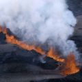
Session 8: Volcanic ash clouds
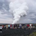
The eruption of Holuhraun in August 2014, in central Iceland, is the country’s largest lava and gas eruption since the Lakagígar eruption in 1783. Although very little volcanic ash was produced, large quantities of SO2 were released into the atmosphere. Two models have been used to simulate the dispersion and transport of SO2 for this event, the Lagrangian particle dispersion model FLEXPART and the on-line coupled model WRF-Chem. Whereas in the FLEXPART calculations no anthropogenic emissions or aqueous-phase chemical reactions are considered, in the WRF-Chem calculations, both are fully included. The results of the simulations are evaluated against satellite (GOME2B and OMI) data, as well as ground based SO2 concentration data. The analysis is conducted on a data management platform, which is currently developed in the frame of the ESA-funded project TAMP “Technology and Atmospheric Mission Platform”: it provides comprehensive functionalities to visualize and numerically compare data from different sources (model, satellite and ground-measurements).
Recording Delia ARIAS ARNOLD