Common Remarks
A tropical cyclone (TC) is defined as a non-frontal, synoptic-scale cyclone, which develops over tropical and sub-tropical oceans and has a clearly defined, organized circulation. These cyclones can vary greatly in intensity, location and appearance. Depending on their location and strength, tropical cyclones are also referred to by names such as hurricane, typhoon, tropical storm, cyclonic storm, tropical depression or simply as cyclone. The Conceptual Model presented here should be regarded as the first phase towards a comprehensive description of tropical cyclone developments.
TCs have very low atmospheric pressures in the calm, clear center (the eye) of a circular structure associated with heavy rains, winds and clouds.
The eye of a TC is surrounded by a ring of powerful thunderstorms that suck up warm, moist air from the ocean surface and hurl it kilometers into the atmosphere, sometimes all the way to the lower stratosphere (i.e. overshootings). TCs carry heat energy away from the tropics and transport it toward temperate latitudes, which may play an important role in modulating regional and global climate.
The North Atlantic is prone to tropical cyclones due to its geographical location. TC Bill (2009) is one example of a strong TC which occurred in the North Atlantic basin during 2009, and which has been examined and described using satellite imagery and numerical weather prediction (NWP) analyses.
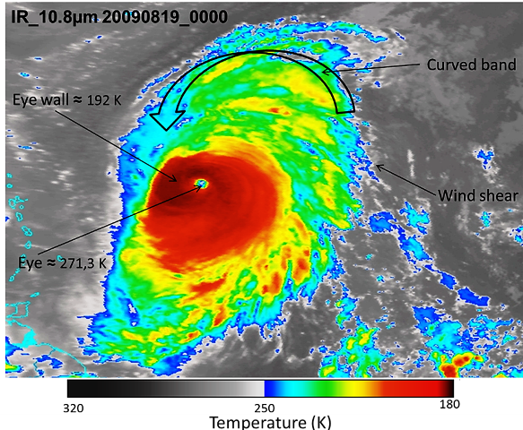
Remote sensing is the primary method used to observe TCs. Enhanced imagery from the Meteosat-9 IR 10.8 band enables us to identify the cloud top patterns around the eye of TC Bill. In detail, we identify three basic TC pattern types: the eye pattern; curved band pattern and wind shear pattern.
|
19 August 2009 / 00:00 UTC. Meteosat-9 Enhanced IR 10.8 image for TC Bill.
|
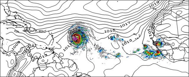
18 August 2009 / 12:00 UTC. Sea-level pressure (SLP) map for the tropical North Atlantic basin. The green, yellow, orange and red colors show intense convection with varying cloud top pattern (Meteosat-9 Infrared imagery) around the eye of TC Bill. The eye also features extremely low surface pressures.
|
|
|
I. Appearance in Satellite Data
Learn about how to recognise and detect Tropical Cyclones over the North Atlantic in satellite images.
II. Meteorological Physical Background
Find out more about the meteorlogical and physical background of Tropical Cyclones over the North Atlantic
III. Key Parameters
Learn which key parameters to use for montoring Tropical Cyclones over the North Atlantic
IV. Typical Appearance In Vertical Cross Sections
Find out the typical appearance of Arctic Tropical Cyclones over the North Atlantic in vertical cross section
V. Weather Events
Explore the weather events associated with Tropical Cyclones over the North Atlantic
VI. References
Let these comprehensive documents in the references assist you in finding more about Tropical Cyclones over the North Atlantic