Webcast


Satellite-Derived Rain Rate from Microwave Sensors Aboard Polar-Orbiting Satellites
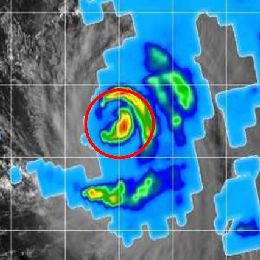
Polar-orbiting microwave sensor generated rain rate estimates are the most accurate satellite-derived estimates of rainfall because of their direct relationship between liquid and ice hydrometeors and surface precipitation. People may find that surprising because the timeliness, latency and spatial resolution are inferior to geostationary satellite rain estimates. But the primary advantage that microwave sensors aboard operational polar orbiters have over geostationary satellites is the ability to see through the clouds and capture what is below the cloud tops. The current operational polar-orbiting satellite sensors aboard the DMSP (SSMI/S sensor) and NOAA/METOP/S-NPP satellites (AMSU/MHS and ATMS sensors) that generate instantaneous areal average microwave rain rates will be presented and explained, along with the recent development of combining these measurements into a Blended Rain Rate Product and an additional blended product called QMORPH. In the future polar-orbiting microwave rain rates will be used as a calibration of the next generation of geostationary satellite-derived rain estimates. A few recent case studies of the best use of operational microwave rain rates will also be shown, as well as those from more research oriented missions, such as GCOM (AMSR-2 sensor) and GPM (GPI sensors) that are also used in operations.
Filed under Keywords:
microwave sensors, polar satellites, precipitation, AMSU, MHS, QMORPH