Webcast


Use of iSHAI and PGE00 tools in pre-convection phase on clear air pixels. Preparation of MTG era
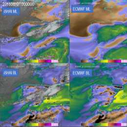
iSHAI (imaging Satellite Humidity and Instability) is the clear air product of the NWCSAF/GEO software that allows the monitoring in clear pixels of several key ingredients in convection; in addition, it allows to identify the regions where the numerical models used as input do not agree with the observation of the satellite. In version 2018, iSHAI has been adapted to Himawari satellites and it is being adapted for GOES-R class satellites.
PGE00 is an AEMET complementary tool that performs first the vertical, temporal and spatial interpolation (4D interpolation) of the profiles from NWP to the projection and time of the satellite images; allowing to generate for all the pixels the same fields that iSHAI. Second, PGE00 can be used to generate synthetic satellite images using RTTOV-12.1 in clear and cloudy conditions with a high degree of realism using the ECMWF model at hybrid levels. In addition to the comparison with real satellite images, synthetic images can be used to generate new developments and for preparation of MTG era through the generation synthetic MTG-FCI and MTG-IRS images.
The NWCSAF products and services for the future MTG-IRS will be also briefly presented.