High Impact Weather - Event Week 2014
![]()
EUMeTrain organised an event week with presentations related to "High Imact Weather" from 8th to 12th September 2014. During this event week,
experts from European, American and Near-East National Weather Services provided an insight into the challenges of forecasting critical weather
events such as storms, avalanches and floods. What uncertainties do forecasters encounter when dealing with high impact weather? How can they
warn people and how long is the lead time?
To obtain a better predictability of high impact weather, it is important to understand the physical/meteorological processes causing them.
This event week offered an online presentations from meteorologists involved in the prediction of extreme weather situations, which are
available here in the form of webcasts.
Session 1: Climatology of High Impact Weather
Climate extremes were discussed in the context of the observed climate change and associated trends. The issue of attributing specific weather extreme to climate change was stressed. Several impacts on human activities was presented and estimated economical and human losses due to the weather and climate extremes were compared over different regions.
Recording Ivan GuettlerZanita gave a brief presentation on the use of satellite data for climate applications and introduce an on-line satellite-based climate viewer that has been published recently.
Recording Zanita Avotniece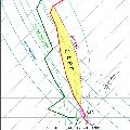
Session 2: A Recipe for Thunderstorms
This talk offered an insight into the ingredients-based forecasting method, which assists an operational forecaster in preparing well ahead of an active thunderstorm day. Mr. Tuschy also gave an overview about certain ingredients which could result in heavy rainfall and flash flooding (due to deep moist convection). He ended his talk with a short overview about ESTOFEX, the European Storm Forecast Experiment.
Recording Helge Tuschy
Session 3: High Waves
For any operation at sea or in the coastal area, forecasts of the sea state are essential. The quality of the those forecasts has steadily improved over the years as attested by the successful forecasts of the many large waves events that affected the Euro-Atlantic coast during last winter. Nevertheless, forecasts of high impact weather can still be uncertain. For this reason, probabilistic forecasting based on ensemble technique should be used to ascertain the probability of extreme weather, including wave parameters, as well as as possible alternative scenarios. It is known that freak waves do occur and can result in major damages and losses. Predicting those events is more challenging, nevertheless advances in the theoretical frameworks for those situations have been made and has resulted in new forecasts parameters.
Recording Jean Bidlot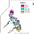
Session 4: Typhoons
Christopher Perez, a weather forecaster of the Philippine Atmospheric, Geophysical, and Astronomical Services Administration (PAGASA) will gave an insight into Typhoons and their features. Specifically, he presented the chronology of events regarding Typhoon "Haiyan", one of the strongest tropical cyclones ever recorded, which devastated portions of Southeast Asia, particularly the Philippines, on November 8, 2013.
Recording Christopher Perez
Session 5: Avalanches
In this presentation one could see a short overview of the interesting and challenging work as an avalanche forecaster. Gernot Zenkl have shown which types of meteorological situation can lead to critical avalanche situations in the eastern Alps. Furthermore he explained the methods we use to inform and warn the people.
Recording Gernot Zenkl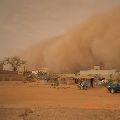
Session 6: Dust Storms
This presentation, after highlighting the major socio-economic and environmental impacts of dust, focuses on the meteorological processes at various scales that are responsible for raising dust/sand storms in the arid Sahara Desert and the semi arid Sahel at its fringes. The challenges facing the weather forecaster in forecasting such high impact weather phenomena and the importance of satellite remote sensing in their monitoring were also addressed here.
Recording Hamidou Hama
Session 7: Winter in USA
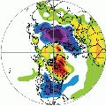
The cool season months of 2014 (JFM) over the U.S. mainland can best be described as much colder than normal across portions of the Great Lakes, Northeast, and Midwest, and much drier and warmer than normal over the west coast, especially California. This talk offered a review of three aspects of the winter/early spring seasons. The first was a review of 12 UTC temperatures for every day in January across the continental U.S. and the relationship of some of the colder mornings with the longer-term record of January mornings back to 1979. The second event of note was the onset of exceptional drought in California. The third event, coming at the end of March, was a look at significant cyclogenesis off the U.S. eastern seaboard on March 25-26.
Recording Gregory Carbin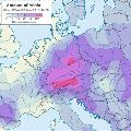
Session 8: Floods in SE Europe
From the beginning, spring 2014 was very rainy in large parts of central and south-eastern Europe. The soil was already saturated with water in the beginning of May, when mid May a huge cyclone, persisting over Bosnia and Herzegovina, Serbia and Croatia for 3 days, caused extreme precipitation. The amounts measured in Serbia and Bosnia and along Sava river in Croatia were in some areas larger then ever measured before. Catastrophic flooding left thousand of people homeless and the consequences will be visible for a long time.
Recording Natasa Strelec-Mahovic