Cyclone Week 2012
From 4 to 6 June 2012 EUMeTrain organised with its partners an event week on Cyclones with a pallet of lectures from presenters from different regions in Europe. The event week consists of several sessions given by different institutes.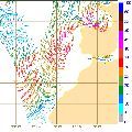
Session 1
Xynthia - Nuno Moreira - Instituto de Meteorologia, I.P.
In this presentation Nuno Moreira talks about Xynthia, a storm that affected North Atlantic and Europe in the end of February 2010. There is a focus on the cyclogenesis process, which fits the classification of a "bomb", and on the remote observation of the storm. This presentation does not only cover MSG imagery, but also ASCAT wind data and derived mean sea level pressure estimates. The advantages and disadvantages of using ASCAT wind in nowcasting for this kind of storms are discussed.
Recording Nuno Moreira
Descending into the maelstrom: Cyclone "Emma" on 1 March 2008 - Georg Pistotnik - ESSL
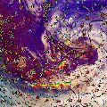
On 1 March 2008, the powerful late winter cyclone "Emma" caused widespread damage and claimed 14 lives in Central Europe. Embedded in the synoptic-scale storm field, deep convection along the cold front played a significant role in further enhancing the wind gusts. This presentation aims to unfurl an outstanding case of a rapid cyclogenesis, to match the events at the earth's surface with the storm structures seen in satellite and radar data, and finally to track down possible mechanisms which may have contributed to paving the way for one of the strongest downbursts ever documented worldwide.
Recording Georg Pistotnik
Session 2
Convective Lines - Wilfried Jacobs - Deutscher Wetterdienst
Convective lines in connection with intense cyclogenesis hit Middle and Western Europe almost every winter season. These lines move very quickly and are often connected with thunderstorms, heavy gusts and graupel or even hail. In this presentation the related conceptual model and the preconvective environment are explained. Based upon different satellite products and additional data an example is discussed.
Recording Wilfried Jacobs
Medicanes - Teodoro La Rocca - Centro Nazionale di Meteorologia e Climatologia Aeronautica
The Mediterranean area can be affected by particular cyclones characterized by an unusual life cycle. This life cycle can be divided into two distinct parts: in the initial part the subject has a warm core and an asymmetric structure, which are typical aspects of a tropical storm. In the second part, it evolves rather like a cyclone of middle latitudes, usually explained by the classical theories; its origin is either on the sea as on the desert. These entities generally include extreme events, such as intense convection, strong winds and coastal storm surges; consequently, they assume a significant importance in the diagnostic and forecasting. This lecture will explain the energy contributions and the thermodynamic processes involved in the entire evolution, also describing the various significant aspects making use of adapted diagnostic procedures.
Recording Teodoro La Rocca

Session 3
Polar Lows - Gunnar Noer - The Norwegian Meteorological Institute
The forecasting of Polar Lows is one of the most challenging tasks in weather forecasting in the arctic. The lecture will give a demonstration of basic forecasting methodology at the Norwegian Meteorological Institute, and show some typical signatures of the polar low as seen from satellite IR/visible imagery, from ASCAT and from other observational data.
Recording Gunnar Noer
Lee cyclogenesis in the Mediterranean: Climatology, lifecycle and predictability - Kristian Horvath - Hydrological and Meteorological Service, Croatia
The classification of cyclones and their tracks in the Mediterranean will be presented, with a special attention on the lee cyclones and their tracks when moving farther from the initiation area. Furthermore, the atmospheric ingredients at play during lee cyclone formation and development will be reviewed, such as the crucial role of the upper-level dynamical factors, but also the near-surface lee-side thermal or potential vorticity (PV) anomalies and surface fluxes, including their interactions with the orography and mutual non-linear synergies. In addition, the use of “PV thinking” will be demonstrated for easier conceptual understanding of the formation mechanisms. The results of numerical studies show that the intensity and track of lee cyclones are very sensitive to the details of the upper-level trough, such as its exact position relative to the mountain, the intensity and existence of sub-synoptic vorticity cores, which may result in reducing the predictability of lee cyclones in the Mediterranean area.
Recording Kristian Horvath
Session 4
New concepts in cyclone and frontal conceptual models - Dr. David Schultz - Centre for Atmospheric Science, University of Manchester, Manchester, UK
This talk presents new conceptual models in cyclone structures and evolutions. How does the large-scale flow in which the cyclone is embedded determine the type of frontal evolution that occurs? What are new ideas in occluded cyclone structure and formation? How does the air flow through cyclones, and what can this tell us about the possibility for deep, moist convection and organized precipitation bands? Are bands on satellite imagery really the location of fronts at the surface? Should we expect that the temperature gradient and wind shift necessarily are collocated with all fronts? How are our conceptual models of fronts being revised through new research? This talk concludes with general principles for how forecasters can improve their skill through the use of conceptual models in operational forecasting.
Recording David Schultz
Session 5
Upper-level fronts, tropopause disturbances, and convection - Dr. Bogdan Antonescu and Prof. Geraint Vaughan - Centre for Atmospheric Science, University of Manchester, Manchester, UK
Forecasting convective storms is one of the most difficult forecast challenges. One feature that has been claimed to have a positive influence and a negative influence on convective storms are tropopause folds, layers of stratospheric air that have been intruded down into the troposphere. To determine the relationship between tropopause folds and convective storms, this talk presents first the main conceptual models for the evolution of the upper-level fronts and associated tropopause folding. "Potential vorticity thinking" represents the framework for this discussion, thus advocating once more the utility of "PV thinking" for operational forecasters, not only as means of understanding the atmospheric dynamics, but also as a useful tool in the forecast process. In the second part of the talk, we will try to disentangle the conflicting paradigms that tropopause folds both promote and suppress convection, by analyzing the influence of tropopause folds on the ingredients for deep, moist convection. At the end of the talk we present some tools that can be used by the operational forecasters to assess the influence of tropopause folds on convection.
Recording Bogdan Antonescu and Geraint Vaughan
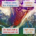
Sting jets - Prof. Geraint Vaughan - Centre for Atmospheric Science, University of Manchester, Manchester, UK
The presentation will discuss the strong winds that are sometimes found in the southwest quadrant of a cyclone and which on occasion can cause damaging winds at the surface. A conceptual model will be presented showing how these winds are related to air streams in the cyclone. Evidence for a distinct airflow known as a 'sting jet' will be presented - this is a descending jet of air reaching the top of the boundary layer a little behind the cold front. Reference will be made to results from recent experimental field campaigns to study this phenomenon.
Recording Geraint Vaughan