Common Remarks
Shallow (less than 1 kilometer deep) cold fronts commonly observed over the Australian region include the late summer cold front (the Type 2 front), Southerly Busters and Central Australian Fronts. In contrast to Conceptual Models of Cold Fronts used in the Northern Hemisphere and based on studies in the United States and the United Kingdom, Australian summertime cold fronts are shallow and have little upper level baroclinicity associated with them. An overview of the location of these fronts is shown below, though it should be noted that one type of front can sometimes transform into another. For example a northward propagating southern ocean front can become a central Australian Front. A long-lived Type 2 front can become a Southerly Buster. Solitary waves may sometimes propagate ahead of these fronts, and these are stable waves that are able to travel upon the low level inversion over large distances.
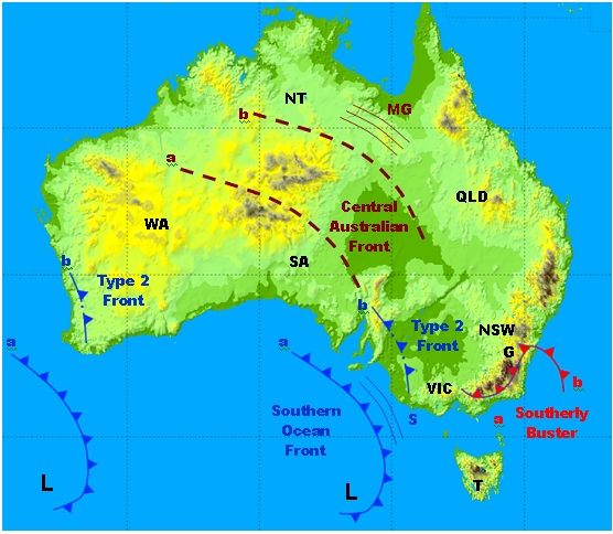
Summary of the Type 2 front, the Southerly Buster and the Central Australian front. Progression of the fronts is annotated as a-b. Also shown are Southern Ocean low pressure centres (L), solitary wave trains that propagate ahead of a Southern Ocean front (S) and Southern Morning Glories travelling ahead of a Central Australian front (MG). Australian states are Victoria (VIC), New South Wales (NSW), Queensland (QLD), South Australia (SA), Western Australia (WA), Northern Territory (NT) and Tasmania (T). The Great Dividing Range (G) is also shown.
Late summer (Type 2) cold fronts
Type 2 fronts consist of a single change line, commonly less than 1km in depth that occur predominantly during late summer (January to March). Due to continental heating in late summer and a lack of significant depth of atmospheric moisture, these fronts lack significant cloud. They are modulated on the mesoscale by surface temperature gradients and the resultant seabreeze circulation and have a lifetime commonly less than 24 hours. These fronts affect southern Australia and have been studied predominantly over southeastern Australia. The monitoring of these fronts is critical in bushfire management. Historically most deaths from bushfires have occurred just after the passage of these fronts.
Southerly Busters
Southerly Busters occur along the southeast coast of Australia to the east of the Great Dividing Range. They are strong, sudden, and squally southerly wind surges of at least 15 m/s and have been known to gust up to 35 m/s and are confined to coastal regions, trapped against the mountains by the Coriolis force. The depth of the surge is generally less than 1km and is below the average height of the Great Dividing Range. Topography and associated mesoscale effects such as upslope flow, channelling and local blocking of the flow influences the propagation of Busters which commonly have a lifetime of less than 24 hours. The Southerly Buster usually occurs in spring and summer, most frequently in December (2.3 per year) and least frequently during September and March (0.7 per year). The city of Sydney receives an average of about five Southerly Busters a year. The strong winds and associated low level turbulence are a hazard for boating and aviation, especially as these Busters occur along the populous southeastern seaboard of Australia.
Central Australian Fronts
Central Australian fronts correspond to subtropical incursions of midlatitude cold fronts into central Australia. These fronts are generally less than 1 kilometer in depth. Central Australian fronts are strongly diurnally modulated, weakening and decelerating during the day and strengthening and accelerating during the night. These fronts normally cross the continent from south to north within a day or two. During September and October a northward moving "Morning Glory" may form over the southern coast of the Gulf of Carpentaria region of northern Australia in association with the Central Australian Front. The "Morning Glory" is a wind squall or a succession of wind squalls frequently accompanied by a roll cloud or a series of such clouds. Central Australian Fronts occur during the cooler months between April and November. 15 central Australian fronts were documented during four field experiments in the decade commencing 1988. During the CAFÉ experiment, conducted during September 1991, three Central Australian fronts were observed. The monitoring of these fronts is critical in bushfire management over the northern Australian savannah.
I. Cloud Structure In Satellite Images
Learn about how to recognise and detect Shallow Cold Fronts in satellite images.
II. Meteorological Physical Background
Find out more about the meteorlogical and physical background of Shallow Cold Fronts
III. Key Parameters
Learn which key parameters to use for montoring Shallow Cold Fronts
IV. Typical Appearance In Vertical Cross Sections
Find out the typical appearance of Arctic Shallow Cold Fronts in vertical cross section
V. Weather Events
Explore the weather events associated with Shallow Cold Fronts
VI. References
Let these comprehensive documents in the references assist you in finding more about Shallow Cold Fronts