Key Parameters
Examination of published literature indicates that the following NWP parameters are important in detecting and nowcasting Australian shallow cold fronts.
- Surface pressure. Surface pressure minima define the location of the continental pre-frontal trough. The diurnal variations in the Central Australian front and its interaction with the Queensland heat trough can be monitored. The strong pressure gradient at the head of the Southerly Buster can be monitored.
- Surface and low level wind speed and direction. Changes in wind direction define the nose of the front. The parameter is particularly useful in defining the location of fronts over northern Australia, where the pressure gradients are often weak.
- Vertical velocity. Important in defining the location of the front, also the strength of the frontal updraft. A sharp maximum in vertical velocity defines the head of the front.
- Low level relative vorticity. Local maxima in cyclonic vorticity define the location of the front. Increase in anticyclonic vorticity is important in identifying the strengthening ridge of high pressure that accompanies the development of the Southerly Buster.
- Low level potential temperature. Gradients in potential temperature define the location of the cold front. This is useful when determining differences in wind change and airmass change times. Also useful in determining frontal substructure, in particular associated solitary waves and Morning Glories.
- Low level potential temperature. Gradients in potential temperature define the location of the cold front. This is useful when determining differences in wind change and airmass change times. Also useful in determining frontal substructure, in particular associated solitary waves and Morning Glories.
- Low level equivalent potential temperature. Gradients in equivalent potential temperature define changes in airmass. This parameter is less influenced by thermal / physical processes than potential temperature.
- Surface temperature. Gradients in surface temperature are important in monitoring frontogenesis (Type 2 front, Central Australian front). Land and sea surface temperature contrasts play a significant role in the propagation of the Southerly Buster.
MSLP, surface wind, surface temperatures
|
|
Figure 21: Parameters: MSLP, surface wind, surface temperatures. Images courtesy of JMA and BOM
|
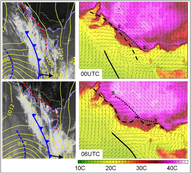
Mean sea level pressure and main synoptic features, trough corresponding to Type 2 cold front in red. superimposed upon the infrared satellite image for the shallow cold front of 17th January 2014 (LHS), Surface wind and temperatures (RHS) with the location of the cold front (bold black line), the pre-frontal trough (dashed line) and the wind change corresponding to the head of the Type 2 cold front (dotted line "s-s").
MSLP, Potential Temperature, Winds and Vertical Velocity
|
|
Figure 22: Parameters: MSLP, Potential Temperature, Winds and Vertical Velocity Left image courtesy BOM, centre and right images from Engel et al. 2012
|
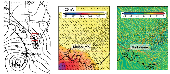
Useful Type 2 front parameters. (LHS) Mean sea level pressure 06 UTC 7th Feb, (CENTER) 500 meter potential temperature (K) and horizontal winds (m/s), (RHS) vertical velocity (m/s) 0615 UTC 7th February
MSLP, Virtual Potential Temperature, Relative Vorticity, Horizontal Winds
|
|
Figure 23: Parameters: MSLP, Virtual Potential Temperature, Relative Vorticity, Horizontal Winds Image from Thomsen et al. 2009
|
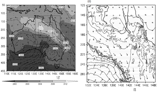
Useful parameters for the Central Australian front. (LHS) ECMWF analyses of MSLP, horizontal wind vectors and virtual potential temperature at 850 hPa at 10EST on 10 Sept. (RHS) potential temperature, horizontal wind vectors and relative vorticity on the omega=0.955 surface at 03 EST on 10 September. The shaded region marks the regions where the magnitude of the cyclonic relative vorticity exceeds 7.5 x 10⁻⁵ s-1 and this clearly shows the position of the front.
SLP, Winds, Vorticity
|
|
Figure 24: Parameters: SLP, Winds, Vorticity. Images from Reid 2000
|
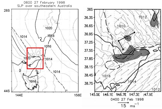
Useful parameters for the Southerly Buster. (LHS) sea level pressure (solid: 1018 hPa, bold), 5 m/s southerly wind contour is dashed, (RHS) seal level pressure (solid: 1014 hPa, bold), wind vectors with scale below, anticyclonic vorticity greater than 10-5 s-1 shaded.