Weather Events
Significant weather events are associated with all of the fronts and these are shown in the schematic diagrams and summarised in the table below. A challenging and significant forecasting problem concerns the tracking of the fronts, which is a particular issue for Type 2 and Central Australian fronts. There is often an abrupt change in frontal location in the transition from weakening Southern Ocean front to the strengthening Type 2 front. The Central Australian front is difficult to locate during the daytime but becomes very well defined at night.
|
|
|
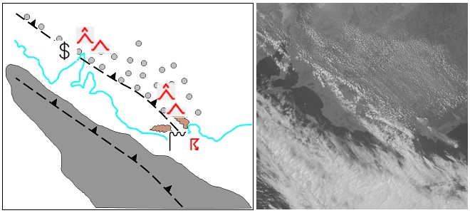
Figure 28: Schematic of weather associated with Central Australian Fronts.
|
|
|
|
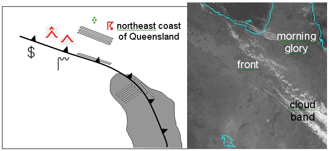
Figure 29: Schematic of weather associated with a Southerly Buster.
|
|
|
|
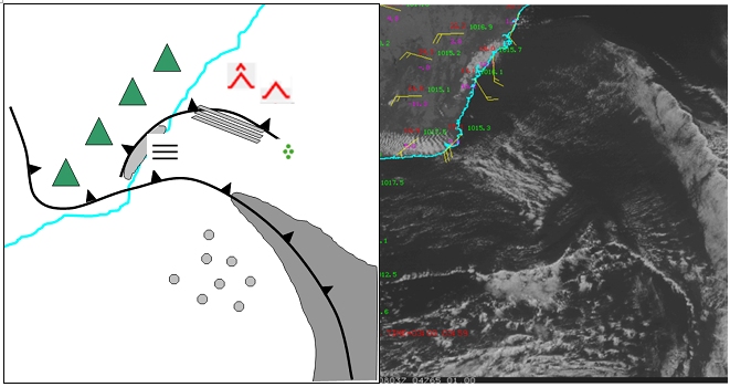
Figure 30: Schematic of weather associated with a Type 2 cold front.
|
| Parameter
|
Description
|
| Precipitation
|
- Central Australian fronts may reach the Gulf of Carpentaria in the north of Australia. As the wet season approaches (November / December) these fronts may trigger deep convective activity as they progress towards the northeast coast of Queensland.
- Southerly Busters may sometimes have precipitation associated with the frontal cloud.
- Type 2 fronts can sometimes interact with bushfires to create pyrocumulonimbus, though any precipitation associated with this will encounter a dry atmosphere in the lower levels.
|
| Temperature
|
- Timing of the arrival of fronts is critical in the accurate forecasting of maximum temperatures. Extremes in temperature are possible with the late arrival of fronts, particularly for Type 2 fronts and Busters.
|
| Wind (incl. gusts)
|
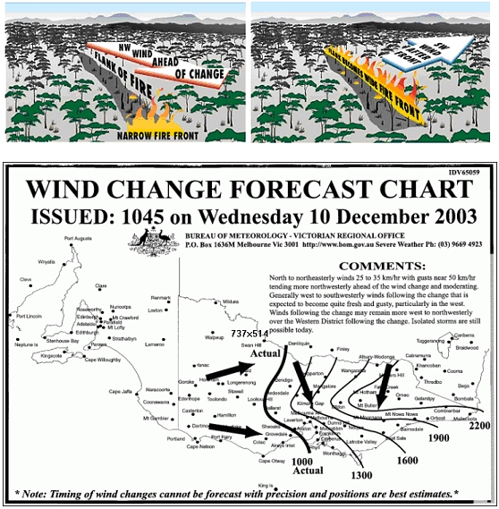
- Wind changes due to the arrival of Type 2 and Central Australian fronts can be critical in the behaviour of large scale bushfires and in determining the strategy required to control these. Type 2 fronts occur during the hottest times of the year, whereas Central Australian fronts commonly occur in the Dry Season when human induced burning of the vegetation occurs over the Savannah of Northern Australia.
- Busters have strong winds associated with the change and this can be critical for boating, especially off the populous southeast coast of Australia during summer. Associated turbulence is also critical for aviation, particularly as there are a number of airports in this region. The Buster does not always have a cloud signature associated with it which will enhance the threat. Central Australian fronts often do not have clouds associated with them.
|
| Visibility
|
- Visibility reduction due to raised dust ahead of Type 2 fronts and Central Australian fronts. Smoke from fires may also reduce visibility. In particular, the interaction between the fronts and the fires can increase smoke output.
- Low cloud can bank up against the escarpment of the Great Dividing range in the lee of the Buster and this can be a hazard for aviation.
|
|
|
|
Figure 31: An example of one of the forecasting issues associated with Australian summertime shallow cold fronts. LHS - the changes in the geometry of the bushfire with the passage of the shallow cold front. RHS - the Wind Change Fire Chart produced by the Australian Bureau of Meteorology.
|