Nowcasting Products
Forecast parameters and fields used for the analysis of convective development (or some other process in the atmosphere) over smaller region, are often not sufficiently accurate. Global models successfully describe the general conditions of the atmosphere, whereas they are less reliable in the smaller scale. Local models (like ALADIN), with better resolution, are much more accurate in describing the atmospheric processes regarding the local effects, such as orography.
Nowcasting products are even more "sensitive" to local conditions, with high resolution in time and space. A lot of nowcasting products
and nowcasting methods, based on satellite data, NWP fields, surface observations and radar data are operationally used for public warning.
A better insight into how and when the nowcasting tools are used can be gained by studying the
"Nowcasting CAL Module" by EUMeTrain.
Nowcasting system in Croatia, developed within the framework of an international project "CEI nowcasting system", is based primarily on the satellite imagery.
Following nowcasting tools are adapted for the operational use:
- cloud motion vectors - calculated from the displacement of the cloud structures in two consecutive images
From this product two following products are derived :
- forecast images or forecast cloud contours - cloud structures are "moved" using cloud motion vectors
- development images or contours - development is calculated by subtracting the motion corrected image in time T from the original image in time T- 1/2, where the motion correction comes from the cloud motion vectors. In this way the motion between two consecutive images is excluded and only development remains.
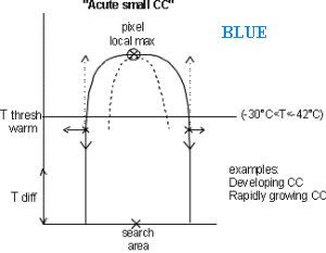
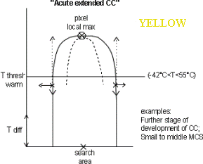
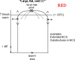
- convective cell detection - cells are detected based upon their temperature, shape and the difference between the cloud top temperature of the cell and its surroundings. Three types can be distinguished :
Cloud motion vectors
In this chapter cloud motion vectors are overlaid on Meteosat 8 IR 10.8 µm images and shown in a sequence of images with 15 min interval.
Forecast cloud contours
Forecast cloud contours are calculated on the basis of the current satellite image and the cloud motion vectors. Isolines of different colours depict the areas with different cloud top temperature (green - cloud top temperature between -20 and -40, blue - cloud top temperature between -40 and -60, and violet - cloud top temperature bellow -60 °C) in time T+1h, which means that the isolines show forecast cloud contours valid in the next hour. Forecast cloud contours are calculated only from the cloud motion vectors using linear extrapolation, therefore the changes in the shape and size of the cloud structures are due to the advection alone.
In this chapter forecast cloud contours are overlaid on Meteosat 8 IR 10.8 µm images.
Development and decay
Development and decay are calculated from two consecutive satellite images with a help of cloud motion vectors. The first step is to apply the reverse cloud motion vectors on the image in time T, gaining the motion corrected image (all the motion has been removed). Than from every pixel value in the satellite image in time T-15 minutes the pixel value from the motion corrected satellite image in time T is subtracted. By this, only those areas remain in which the development or decay (decrease or increase of the pixel value) occurred in the past 15 minutes.
In this chapter the contours of development (orange and red) and decay (blue) are overlaid on Meteosat 8 IR 10.8 µm images.
Convective cell detection
The algorithm detects convective cells on the basis of their top temperature, radius and the difference between the temperature of the top and the temperature of the surrounding pixels. Three types of convective cells are distinguished: the blue crosses indicate the cells with cloud top temperature between -30 and -42°C, the yellow between -42 and -55°C and the red stand for the cells with top temperature lower than -55°C.
In this chapter signs for convective cells (red, yellow and blue crosses) are overlaid
on Meteosat 8 IR 10.8 µm images.
Temperature enhancement - "Coldring"
In this chapter Meteosat 8 colour enhanced IR 10.8 µm images are shown. Colour scale stands for the cloud top temperature ranging from -34 to -72 °C. This enhancement enables the study of the cloud features like cold-U shape and cold-ring shape and the temperature of the cloud tops in more detail.