In the first image the clouds over the north Adriatic have top temperature up to -45 °C, and probably bring some rain in these areas. There is no significant convective development over Croatia jet.
The first sign of convection, just a few coloured dots, can be recognised over the islands in the north Adriatic.
15 minutes later clouds over the island of Rab in the north Adriatic develop and have a cloud top temperature around -50 °C.
Further development over the north Adriatic, with red dots over the island of Rab (temperature around -65 °C) can be seen. Around this time hail was reported at the island of Rab.
Induced by orography, development goes on over inland.
At this time step severe storm, which started few time steps before, forms a cold-U shape (marked by arrow). This significant cloud-top feature, observed by the weather satellites, is commonly ranked as an indicator of storm severity.
Development and propagation of the storm cell to the east goes on. Cold-U shape can still be recognised.
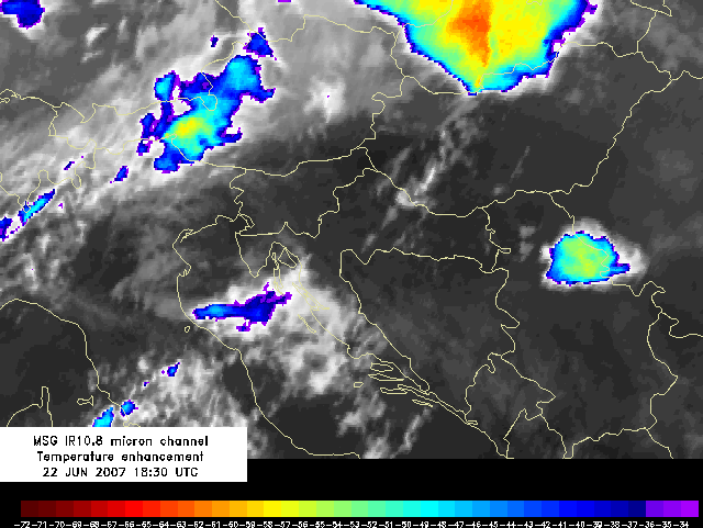
Propagation of the cell to the east goes on, but the cold-U shape disappeared. Cloud top temperature of the cell becomes higher, but still is up to -55 °C.
Situation similar to the one 15 minutes before. In the south-westerly flow, induced by the orography, a sign of new development can be noticed.
In the south-westerly flow, induced by the orography, several new convective cells can be noticed.
Further movement of the big convective cell to the east can be followed. The area of convective development more to the south-west becomes larger.
Further movement of the big convective cell to the east can be followed. The area of convective development more to the south-west becomes larger.
Cloud top temperature of the western convective system becomes lower.
Few minima of the cloud top temperature (above -60 °C) appeared over the border of Croatia and Bosnia and Hercegovina. These cold cloud tops consist of ice particles.
Development over Croatia and Bosnia and Hercegovina goes on. The cloud tops of the cell more to the east are getting warmer, indicating dissipation.
Development over Croatia and Bosnia and Hercegovina goes on.
Strong convective development can be observed over the central part of Croatia with high reaching cloud and cloud top temperature lower than -65 °C.
The system moves to the north-east, development goes on and the area of convectivity becomes larger.
The system moves to the north-east, development goes on and the area of convectivity becomes larger. Significant development occured more to the north-west. Severe updrafts within this cell caused hail over the north-west part of Croatia (also recorded by hail-pads).
The system moves to the north-east, development goes on and the area of convectivity becomes larger.
The system moves to the north-east, development goes on and the area of convectivity becomes larger.
The system moves to the north-east, development goes on and the area of convectivity becomes larger.
The system moves to the north-east, development goes on and the area of convectivity becomes larger. The significant development this time occured over the eastern part of Croatia, near the border with Bosnia and Hercegovina. Hail is recorded by hail-pads.
The big convective system moves mainly to the north-east. The strongest convective development can be recognised over the north-west and east Croatia.
The big convective system moves mainly to the north-east. The strongest convective development can be recognised over the north-west and east Croatia.
The big convective system moves mainly to the north-east. The strongest convective development can be recognised over the north-west Croatia.
The majority of severe convection over the east Croatia moves to the north Serbia. A new shape appears as indicator of storm severity - a well-defined cold-ring feature (marked with an arrow).
Temperature difference between the cold-ring and the central warm spot (CWS) is about 8 deegres.
The cold-ring can still be recognised. Convective development over the north-west Croatia is still present.
The cold-ring slowly looses its shape.
The new cold-ring (marked with an arrow) appears just next to the decaying one. Severe convection over the north Croatia is still present, with cells with cloud top temperature up to -65 °C.
The cold-ring shape disappeared, and the convection over the north Croatia goes on.
Convective development over the north and north-east Croatia goes on.
Convective development over the north-east Croatia is still rather strong. The cloud top temperature is above -50 °C.
Convection over Croatia is decaying. A lot of hail was recorded by hail pads between 0130 and 0300 UTC.
Convective development over Croatia is decaying and the system moved to the north-east.
Convective development over Croatia is decaying and the system moved to the north-east.
Convective development over Croatia is decaying and the system moved to the north-east.
Convective development over Croatia is decaying and the system moved to the north-east.