Summer convection over Germany: 20 and 21 June 2007
Author
DWDWilfried Jacobs
Introduction
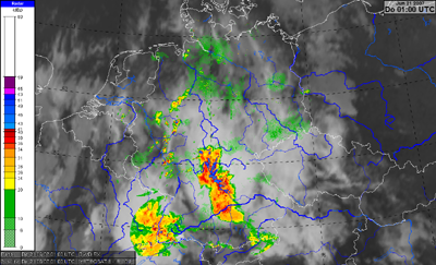
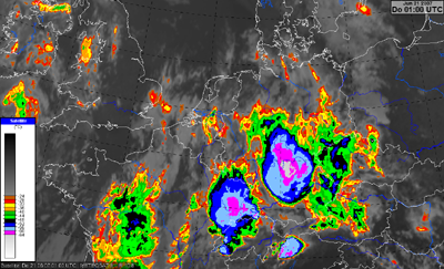
On 20 and 21 June 2007 single, multi and also super cells developed over Germany. From 20 June evening to 21 June morning a mesoscale convective complex moved from South Germany to the North. Heavy precipitation (up to 70 mm/h, Langen (near Frankfurt)) and hail were observed.
Because in many other case studies dynamical processes were deeply investigated we will concentrate in this chapter upon typical structures we can find in this case study and the strongnesses and weaknesses of different remote sensing data (satellite, radar).

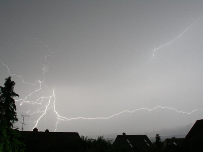
Lightnings near Ehingen (southeast of Wuerzburg) during night 20/21 June 2007
(Source: www.sternwarte-ehingen.de/Wetterdaten/Gewitter/Gewitter_0153.JPG)
 |
 |
| Radar-composite: 21 June 2007: 01 UTC. | Meteosat-8 IR10.8 Enhanced: 21 June 2007: 01 UTC. |
There were some phenomena in association with summer convection occurring during this time period:
- Development of a squall line
- Development of super cells and mesoscale convective complex (MCC)
Data sources considered more in detail:
- Satellite imagery:
- IR10.8 Enhanced
- Convective Storms (software from Daniel Rosenfeld)
- DWD RX (DWD national radar composite)
- Nowcasting-SAF-products: GII
Preconditions likely for thunderstorms:
- Potential instability
- Upward motion
Initiating mechanisms for convection:
- Diabatic heating through insolation (free convection).
- Warm air advection in lower levels and cold air advection in upper levels yielding increased vertical temperature gradient
- Orographic induced upward motion (forced convection)
- Upward motion due to synoptic forcings (e.g., leading edge of a trough, convergence near surface).
Because in many other case studies such processes are already investigated we will concentrate in this part upon the interpretation of different remote sensing data and will consider the advantages and disadvantages of the different data sources.
Following conceptual models are considered:
- Squall line
- Super cells, mesoscale convective complex (MCC)