Meteorological Physical Background
Bora blows from the NE quadrant over the coastal mountains, which are approximately 1000 m high, usually bringing colder and relatively drier air to the Adriatic. The northern Adriatic severe bora is more frequent than its more complex southern counterpart. It is particularly severe in the lee of the Velebit mountain range, the steepest and most pronounced mountain range in the Dinaric Alps in Croatia. The highest wind speed was measured in the southern Velebit region: 69 m/s (248 km/h). Several factors contribute to Velebit being the location of frequent severe bora outbreaks. Its orientation is perpendicular to the northeasterly winds, it has gentle windward slopes and particularly steep leeward slopes, which generate large mountain gravity (buoyancy) waves, and there are several prominent narrow mountain passes.
It was generally thought before (and the claim can still be found in some mistaken explanations) that bora is a falling, mostly thermodynamically driven "katabatic" type of wind. However, this impression has changed due to numerous studies that have shown that severe bora forms in a hydraulic-like flow, with mountain wave breaking as the main mechanism of generation.
Synoptic situations typical for the onset, persistence and cessation of bora are related to the location of cyclonic flow in the proximity of the Adriatic Sea and/or a high-pressure center above central Europe. These synoptic pressure patterns over Europe can be used to distinguish between an anticyclonic and a cyclonic bora. The anticyclonic ("clear") bora develops when a high-pressure system dominates over central and western Europe (upstream of the Dinaric Alps) and the low pressure center is located over the eastern Mediterranean. The cyclonic ( "dark") bora, on the other hand, is associated with the existence of a low-pressure area over the Adriatic Sea or central Mediterranean.
Bora is stronger and more frequent in winter, when it typically lasts for several days. It blows hardest when a high-pressure area sits over the snow-covered mountains of the interior plateau behind the Dinaric coastal mountain range and a low-pressure area lies further south over the warmer Adriatic Sea. The cyclone over the sea draws the lower tropospheric air from the continent over the coastal mountains, easily passing between the foothills of eastern Alps and the broad Balkan mountains. Similarly, a high pressure pushes the air from the large Pannonian Plain and central Europe towards the Adriatic over the coastal mountains.
A cold front's passage over the area sometimes also induces a relatively short lasting bora.
A shallow bora occurs when the flow is confined to the lower troposphere only, separated from the flow aloft by a strong temperature inversion or a change in wind direction with height. A typical example is a bora occurring with a high ridge reaching southwards from a large, strong Siberian high in winter.
Another example of a bora's generation mechanism is Alpine lee cyclogenesis. It primarily occurs around the Gulf of Genoa, consequently creating a secondary ("daughter") cyclone over the Adriatic. It locally reduces the pressure over the Adriatic, creating favorable pressure gradients for bora formation. Intense lee cyclones synchronized with the upper tropospheric flow produce deep bora that blows throughout the troposphere.
|
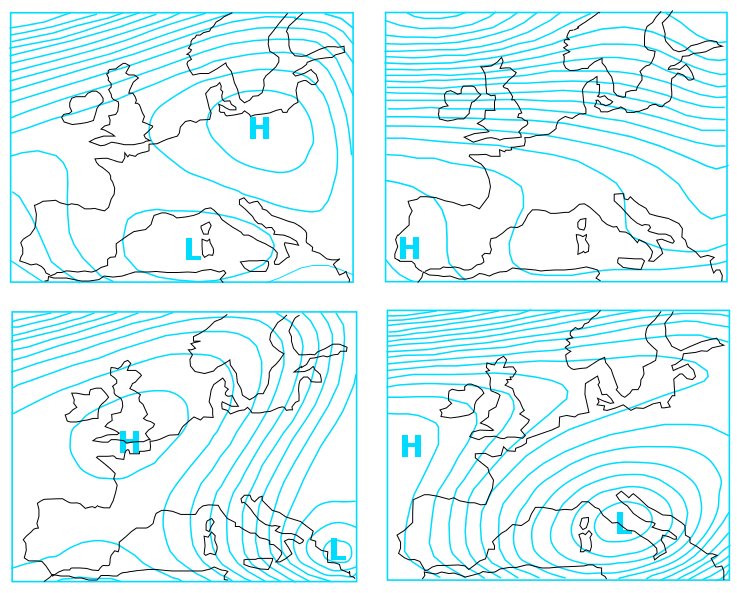
Synoptic situations in which a bora typically develops can be divided into 4 groups (Heinmann, 2001) according to their appearance in the 500 hPa field:
|
|