Weather Events
Principal weather events following the strong cross-equatorial flow are heavy precipitation and wind gusts. Many areas also experience floods or landslides.
| Parameter | Description |
|---|---|
| Wind | Strong wind gusts occur in west to central Java leading to falling trees and damaged houses. |
| Precipitation |
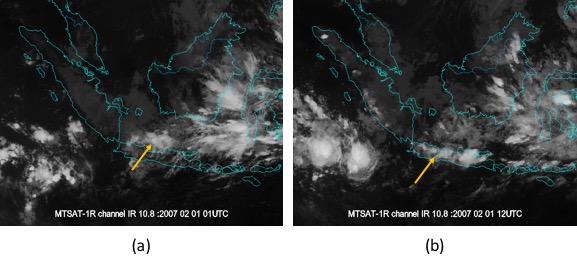
In the western part of Java, the normal diurnal cycle shows deep convection from late afternoon to evening in mountainous areas and from evening to early morning in flat areas like Jakarta. The NCS changes that normal diurnal cycle behavior and triggers deep convection induction from early morning to early afternoon, which leads to persistent heavy precipitation.
Orographic lifting of the air against the mountain range in West Java, particularly in Jakarta, is caused by the northerly flow. The lifting is responsible for above normal heavy precipitation. |
The presence of this strong cross-equatorial flow in the Maritime Continent is a dominant factor for anomalous weather events in the Java Sea, particularly in the western and central parts of Java and southern part of Sumatra. These early morning to early afternoon rainfall events have been observed in both the classic NCS pattern and the NCS+MJO pattern. Only when the cross-equatorial flow is particularly strong does it affect the southern part of Sulawesi as well.
Weather event on 1 February 2007
|
|
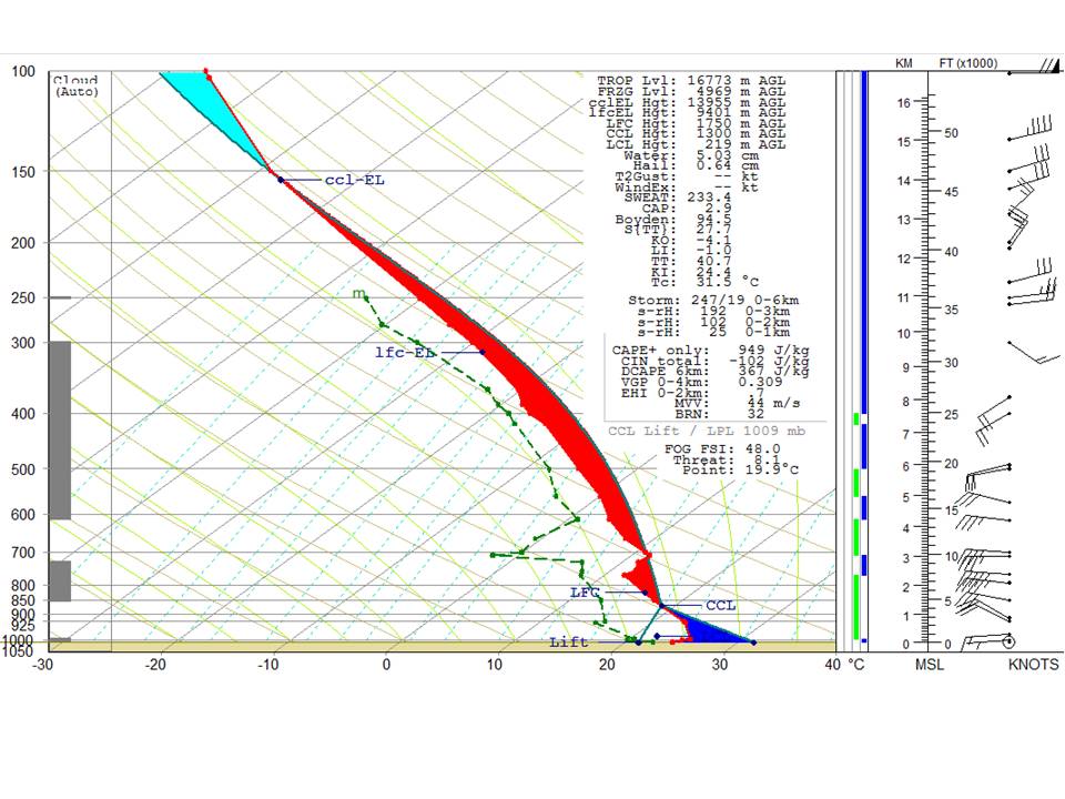
The Skew-t diagram above shows the vertical profile of the troposphere at the Soekarno-Hatta Meteorological Station, Cengkareng, in the northwest of Jakarta. The troposphere is conditionally unstable and indicates a strong convective potential, with the base of Cb clouds at 850 hPa. There is a strong wind shear in the upper troposphere, where the 20-knot southwesterly wind at 400 hPa turns into a 45-knot northeasterly wind at 150 hPa.
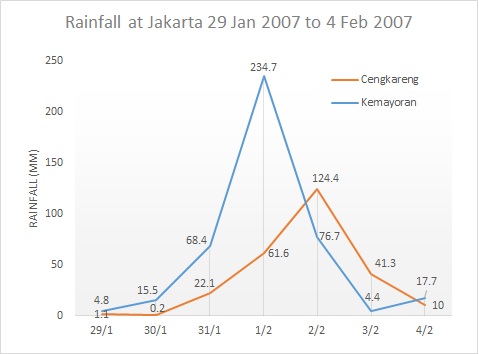
The graph of rainfall at Jakarta shows the plot of daily rainfall data that was observed from 29 January 2007 to 4 February 2007. The heavy rainfall (more than 50 mm/day) was recorded at the Kemayoran station from 31 January to 2 February 2007. On 1 February, it reached the highest point of 234 mm in a day, close to Jakarta's monthly rainfall average of 300 mm. Meanwhile in Cengkareng, heavy rainfall was observed from 1 to 2 February 2007. These persistent torrential rains measured in two stations located in Jakarta verified that the low-level moisture transport brought by the strong cross-equatorial northerly surge affected the diurnal cycle in the western part of Java.
|
Another way to describe the 2007 NCS case is with a meteogram.
|
|
|
|
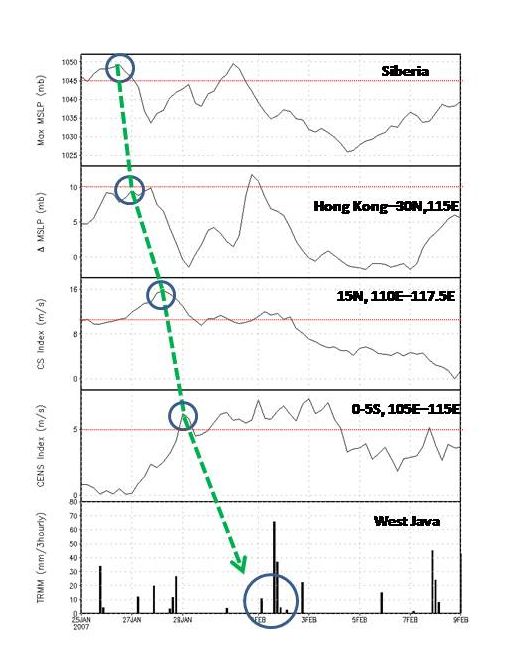
The meteogram displayed above represents the propagation of the early 2007 NCS case, from its outbreak in Siberia, across the South China Sea and far south to West Java. It shows the thresholds of the relevant NWP parameters day by day, making it a useful tool for forecasters in identifying the characteristics of a NCS event, and in keeping track of its southward propagation. A severe weather warning would be issued when the pressure gradient between Hong Kong and 30°N, 115°E reaches the threshold.
As shown here, the surge episode started on 26 January 2007 (blue circle line in panel 1) showed that the MSLP in Siberia reached more than 1045 hPa. Panel 2 shows the pressure gradient between Hong Kong and 30°N, 115°E which reached around 8 mb by 27 January 2007 (blue circle) and confirmed that the center of high pressure had propagated southeastward. The third panel shows that the cold surge index was reached on 28 January 2007 (blue circle), which confirmed the strengthening of northeasterly wind in the South China Sea above 8 m/s. The surge finally crossed the equator on 29 January 2007 with northerly wind exceeding 5 m/s. This led to the heaviest precipitation occurring in West Java on 1 and 2 February 2007.
|
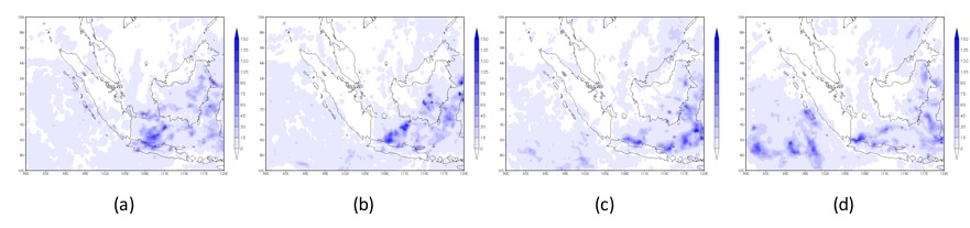
TRMM daily rainfall on 29 January (a), 30 (b), 31 (c) and 1 February, 2007 (d)
|
|
|
|
|
Cloud patterns over Java on 01 February, 2007. Morning (a) and afternoon (b)
|
|
|
|