Meteorological Physical Background
Introduction
One of the most intriguing aspects of the Asian winter monsoon circulation is the development of Northerly Cold Surge (NCS), which forms when cold air is advected south along the eastern edge of the Siberian-Mongolian High (SMH). The cold surge can reach equatorial latitudes where it manifests as strengthened northerly or northeasterly winds. A corresponding temperature signature may not be present due to the influence warm sea water has on the surge. Depending on the thermodynamic characteristics of the pre-incursion environment, cold surges may also have a substantial impact on convection and rainfall in the tropics.
Broad Overview
The interaction of northeasterly winds with local topography and the dynamic response to the change in latitude contribute to the turning of the winds. In all cases, the surge takes the form of a shallow dome of cold air moving parallel to the contours of terrain elevation. Shallow surges of cold dry air are frequently observed to the east of the major mountain ranges, moving from the mid-latitudes into the tropics.
|
Topography and areas of frequent occurrence of cold surges. The darkest shading indicates terrain elevations above 5000 m above MSL (Modified from Garreaud, 2001).
|
-edit2.jpg)
|
NCS exhibit a transient, gravity wave-like motion caused by a pressure-wind imbalance, which allows a fast propagation of energy from the mid-latitudes to the tropics (Chang, 2005). The NCS has two stages:
- The edge, a pressure surge, travels at a speed of ~ 40 m/s which is much faster than the advective speed and is therefore suggestive of a gravity wave-like propagation;
- The front, a significant drop in dew point that travels at speeds of only ~ 10 m/s
|
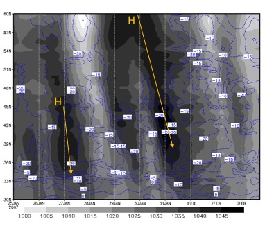
The southward propagation of SMH along 108°E (northern China) from January to February 2007 as a function of latitude. Shaded : mean sea level pressure, contour : dew point temperature
|
|
There is increased moisture transport to the equator during an NCS. This fuels the development of deep convective activity over Indonesia, where moisture convergence strengthens.
Life cycle
An NCS event may last from a few days to a week.
Siberia : Pressure surge outbreaks
The characteristics of cold air outbreaks are closely associated with the formation, intensification, southward movement, transformation and dissipation of the Siberian-Mongolian High. The surge initiates when the Siberian high intensifies above 1045 hPa.
(See: the temperature profile schematic in the chapter on Vertical Cross Sections)
Phase 1: The arrival of the surge
The NCS's arrival at Hong Kong is marked by a dramatic 12 - 24 hour change in synoptic conditions. Wu and Chan (1995) showed that the NCS brings decreased near-surface temperature (around 4-5 °C), decreased humidity (shown by an increase in dew point depression around 1-2 °C), increased surface pressures (approximately +3 hPa), and strong northerly winds of around 5.5 m/s within a period of 12 - 24 hours. Riehl (1968) proposed a large pressure difference between 30°N, 115oE and Hong Kong exceeding 10 mb as the surge forecast criterion of an NCS.
|
Composite variations of surface meteorological parameters measured in Hong Kong during the passage of an NCS. The time frame is from two days before the event to two days after it. Day 0 is the day the NCS arrives at Hong Kong. (a) Deviation of mean sea level pressure from day 0, (b) actual, easterly and northerly components of the surface wind, and (c) surface temperature (solid) and dew point depression (dashed) relative to day 0. The vertical bars in all diagrams indicate the standard errors of the data within the sample. (Adapted from Wu and Chan, 1995)
|
.jpg)
|
Phase 2: NCS propagation through South China Sea
On synoptic time scales, northeasterly cold surges often dominate the low-level circulation patterns over the equatorial South China Sea (SCS). Although cold surge winds are typically dry, they gain moisture while crossing bodies of warm water, thus enhancing the East Asian Hadley Cell together with the strengthening upper-tropospheric flow.
Chang et. al. (2005) devised a cold surge index to define the occurrence of cold surge in this area using the average 925 hPa meridional wind between 110°E and 117.5°E along 15°N. A cold surge event occurs when this index exceeds 8 m/s. Furthermore, based on the magnitude of the meridional wind, the surge is divided into the following categories:
- Weak surge: surge index between 8 and 10 m/s
- Moderate surge: surge index between 10 and 12 m/s
- Strong surge: surge index greater than 12 m/s
Phase 3: Cross-Equatorial Northerly Surge
The cold surge can transport a low-level air mass from the mid-latitudes to the equator quite effectively. As this cold and dry air mass (referred to as 'cold tongue') moves into low latitudes, strong surface heat fluxes weaken the cold air anomalies, and the surge may lose its 'cold' character. However, strong meridional winds remain as clear signatures of the surge. This factor is important in for the formation of precipitation over the Maritime Continent. Hattori (2011) defined the Cross-Equatorial Northerly Surge (CENS) index as the speed of the average meridional wind that exceeds 5 m/s in the area (over 105°E - 115°E, 5°S - EQ).
|
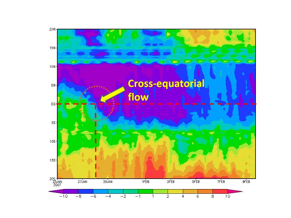
The meridional wind along 1085°E as a function of latitude during the 2007 NCS event, 27 January - 1 February 2007. The circled area shows how the strong northerly wind of more than 5 m/s penetrates past the equator and reaches the index of cross-equatorial northerly surge (CENS)
|
|
Soon after the cross-equatorial flow reaches Java, a zonally elongated rain band forms around 5oS - 6oS, 106oE - 119oE. A persistent northwesterly wind near the surface over the Java Sea creates an intensive low-level wind convergence and a strong low-level vertical wind shear over the island, which build up the necessary unstable conditions for organized convection. The diurnal cycle of heavy rainfall in western Java is thus affected by the collision of the NCS with the nocturnal land breeze. A semi-diurnal cycle becomes dominant and the heaviest precipitation develops during the early morning.
Interactions
During its southeastward propagation, the NCS interacts with other synoptic disturbances as follows:
-
Borneo Vortex, which is a closed counterclockwise circulation on the 925 hPa wind field within the area of 2.55°S-7.55°N, 107.55°-117.55°E in the equatorial South China Sea. During surge events, deep convection occurs in association with the blocking of the low-level winds by the terrain in the northern part of Borneo island, which causes a shift of the convection pattern downstream of the converge maximum at 925 hPa. The shift is smaller at 850 hPa because there is less blocking of winds at higher elevations.
Smoothed topography of the area within which the Borneo vortex is identified. The black horizontal bar is the area for the surge index (Adapted from Chang, 2005)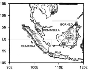
- Madden-Julian Oscillation (MJO) is an eastward movement of large-scale circulation cells oriented in the equatorial (zonal) plane in the troposphere. The MJO is associated with enhanced low-level convergence and ascent in the synoptic scale, while winds in the upper troposphere diverge from the updraft. This circulation is accompanied by enhanced deep convection. Its cycle is split up into eight phases, each of which corresponds to 1/8 of the full cycle. An individual MJO event can last anywhere from 30 and 60 days.
These interactions induce different cloud patterns compared to NCS cases without MJO.
|
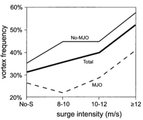
Summary of the percentage of days with no surge (No-S), weak surge (8-10), moderate surge (10-12), and strong surge (>12) that also contain a vortex for all days (total), no MJO days, and MJO days (Adapted from Chang, 2005)
|
|
Interaction with Borneo Vortex (second cloud pattern)
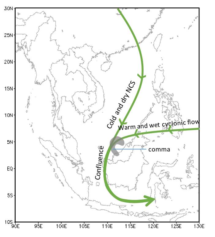
When both surge and vortex are present, the latter deflects the low-level winds. The warm and humid cyclonic southeasterly flow then collides with the NCS (relatively cold and dry) in the northeastern sector of the mesoscale cyclone, generating a comma-shaped cloud structure in the equatorial South China Sea. The frontal confluence generates strong rising motion, which enhances condensation and rain within the comma tail. In the northwestern sector of the vortex, the intense upward motion and rainfall within the comma head are generated by the confluence of the warm, humid easterly flow that occurs ahead of cyclones, as well as the cool and dry northeasterly surge. Thus the strength of deep convection over the equatorial South China Sea becomes much stronger as the presence of the surge increases the strength of the vortex.
|
Schematic showing the formation of the Borneo Vortex at the confluence of NCS and easterly wind.
|
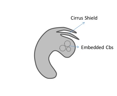
Comma-shaped structure in Borneo Vortex
|
|
|
Interaction with MJO and the Borneo Vortex (third cloud pattern)
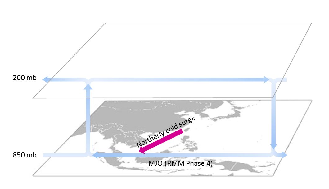
When these three synoptic disturbances occur simultaneously, the MJO circulation pattern inhibits the northerly wind surge's development and southward progression, generating a carrot-shaped cloud structure around the Java Sea. The Borneo vortex keeps the NCS-vortex cloud pattern while enhanced convection develops north of the equator. Further, the MJO circulation reduces the NCS frequency subsequently.
|
Schematic about NCS's interaction with MJO
|
|
Seasonal Variability
Between boreal summer (June to August) and boreal winter (December to February) the maximum heating moves from South Asian region to the Maritime Continent - Northern Australian region. This seasonal variation changes also the thermal circulation. The Winter Asian Monsoon circulation encompasses a large meridional domain causing the tropical region to have a strong interaction with the extratropical region. The extratropical component of this circulation is the NCS. Chang (2005) showed that, typically, about one or two NCS cases occur per month during the boreal winter.