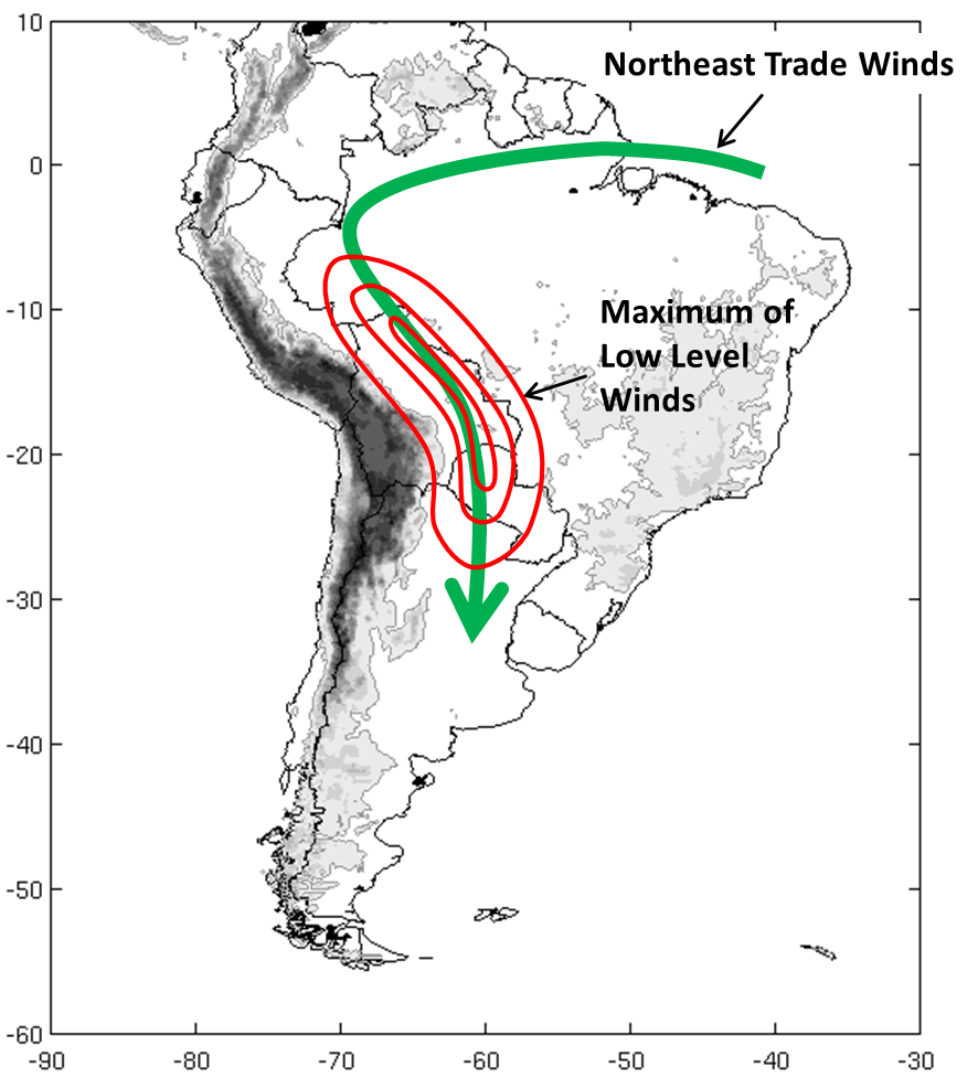
Meteorological Physical Background
The Andes, which is one of the major mountain ranges in the world, blocks and deflects the low level circulation associated with the trade winds to higher latitudes producing a low level current, that is known as the South American Low Level Jet (SALLJ).
|
|
SALLJ has a strong influence on the development of deep convection over the SESA region. The decelerating leading edge of the flow promotes strong convergence of the horizontal wind field, thus allowing low-level moisture to ascend into the free troposphere. If it occurs in an unstable synoptic-scale environment, it can result in the development of large MCSs.
SALLJ is also involved when shallow cumulus clouds aligned with the low-level wind shear organize as cloud streets. These cloud streets can be present in each of the three types of SALLJ described in the next section.
Broad Overview
There are three different types of SALLJ, each associated with a different circulation pattern in SESA:
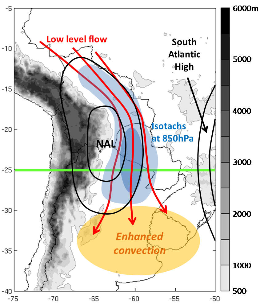
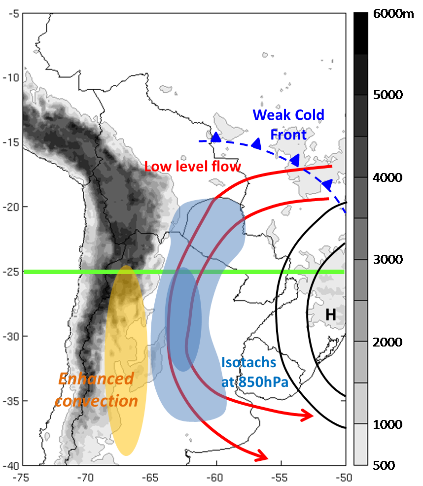
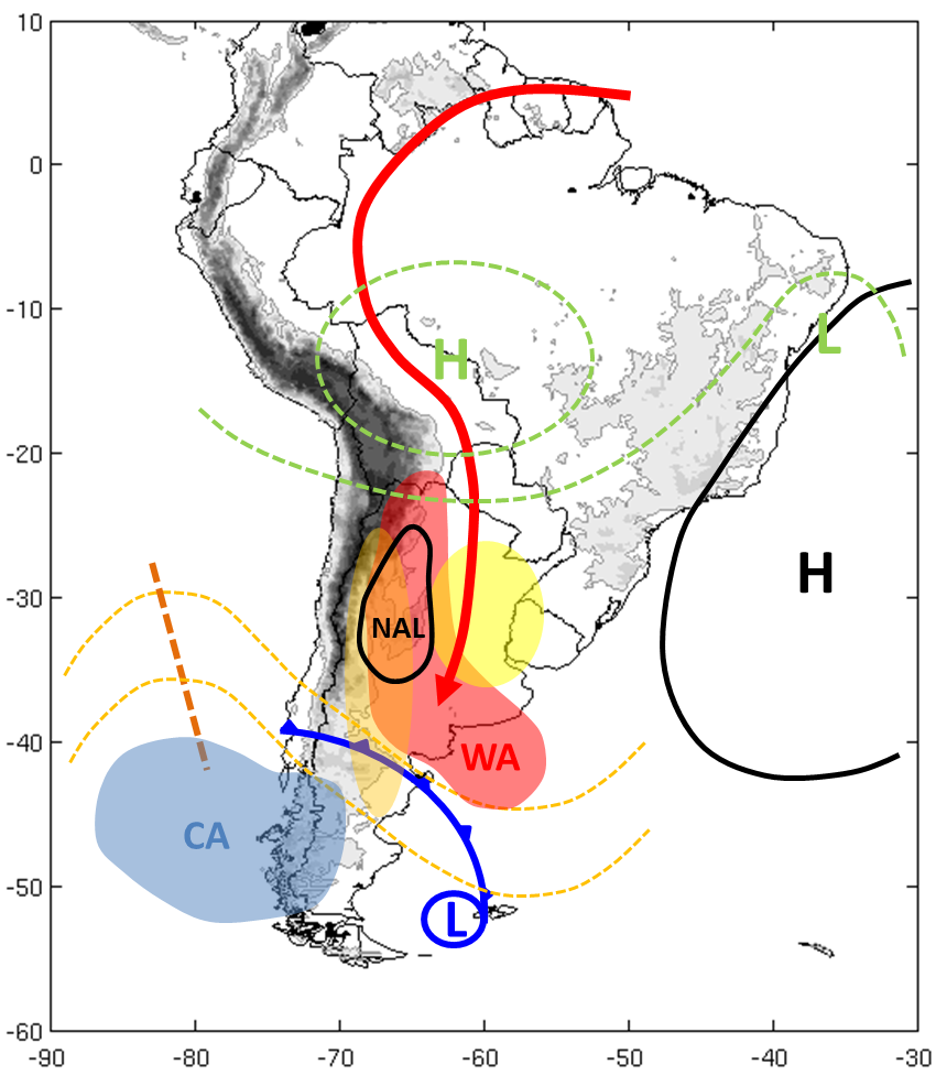
a) Chaco Jet Event (CJE)
This event occurs when the SALLJ's wind maximum penetrates south of 25°S. The meridional flow lengthens as a consequence of the deepening of the thermal North Argentinian Low (NAL) commonly observed over northwestern Argentina near the Andean slopes (*). The interaction between the NAL and the Atlantic high strengthens the pressure gradient and, by so doing, increases the northerly wind component.
The thermodynamic structure and winds of the Chaco jet enhance convective instability by transporting heat and moisture over SESA. The low- and mid-level moisture flux convergence over the region is ten times greater than the summer mean during this event. The CJE only represents 17% of the mean climatological values of the summer season in the southern Argentina, but accounts for a significant amount of the precipitation in SESA (Salio et al., 2007). Most of the convective activity occurs over central and eastern Argentina, southern Brazil and Uruguay.
|
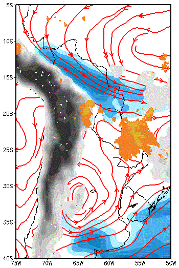
Schematics of the circulation in low levels during a CJE.
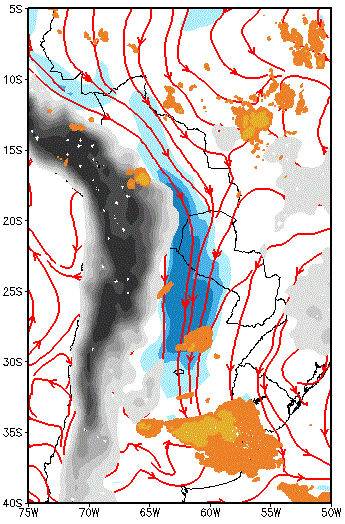
|
Example: 7 January 2001, 06:00 UTC; red: streamlines 850 hPa; blue: isotachs 850 hPa > 10 m/s; dark orange: IR brightness temperature < 235K; light orange: IR brightness temperature < 210K.
|
|
|
(*)The North Argentinian Low (NAL) is a thermal-orographic low pressure arising from the Chaco Low (CHL). Its mean location is around 30°S- 66°W, but it has a relatively high latitudinal variability. While it is more persistent and intense during the summer, it also occurs intermittently during the winter. The deepening of the NAL relies on two main factors: subsidence of the upper-level flow crossing the Andes, and surface heating at low levels.
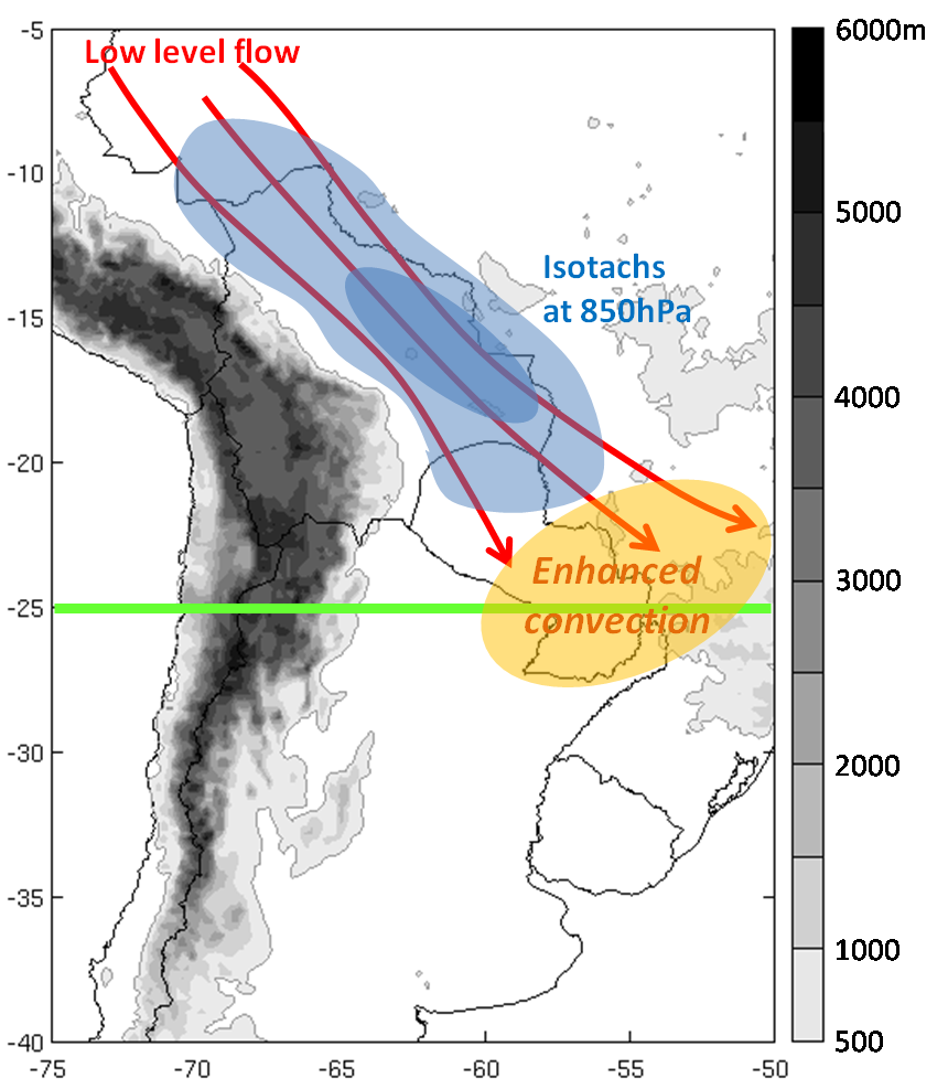
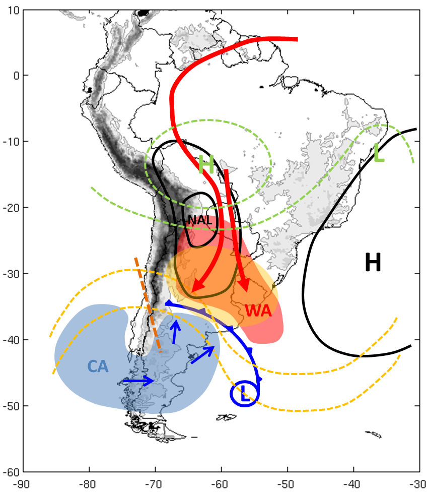
b) No Chaco Jet Event (NCJE)
The configuration of these events is similar to that of the CJEs, but the wind maxima do not penetrate south of 25°S. During a NCJE, the wind is more zonal than meridional, whereas with CJEs the meridional component is the most important one.
Convection tends to develop between northern Paraguay and southern Brazil.
|
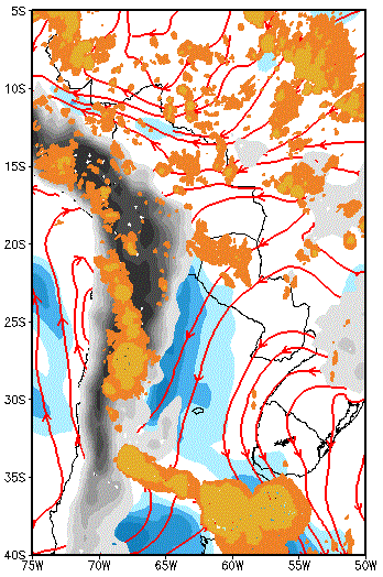
Schematics of the circulation in low levels under NCJE event
|
Example: 6 January 2003, 12:00 UTC; red: streamlines 850 hPa; blue: isotachs 850 hPa > 10 m/s; dark orange: IR brightness temperature < 235K; light orange: IR brightness temperature < 210K.
|
|
|
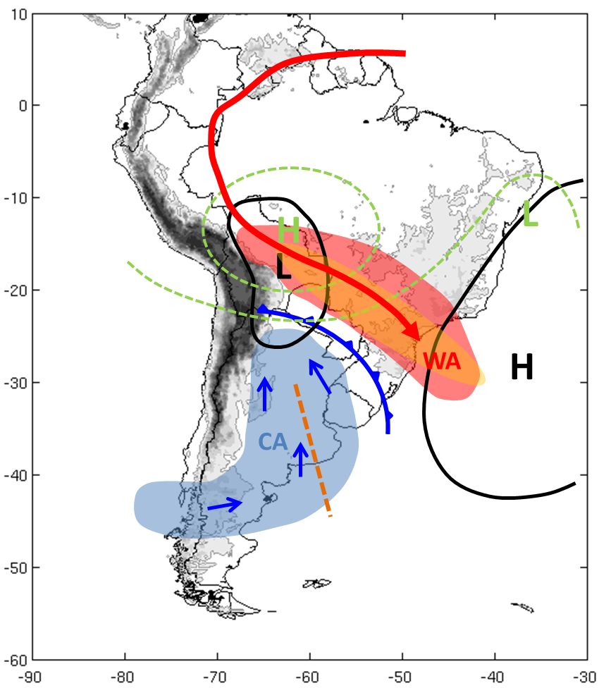
c) Argentinian Low Level Jet (LLJ-ARG)
There is another LLJ east of the Andes that is independent from the northerly SALLJ. It develops along the western periphery of a postfrontal anticyclone. In these cases, in contrast to CJEs and NCJEs, the main source of moisture is the Atlantic Ocean. Precipitation develops along the eastern slopes of the Andes in central and northwestern Argentina.
|
Schematics of the circulation in low levels under LLJ-ARG event.
|
Example: 1 March 2001, 00:00 UTC; red: streamlines 850 hPa; blue: isotachs 850 hPa > 10 m/s; dark orange: IR brightness temperature < 235K; light orange: IR brightness temperature < 210K.
|
|
|
Seasonal variety of the low-level jets
Table 1 shows the frequency of days with different types of LLJ during the four seasons (SON=spring, Sep-Nov; DEF=summer, Dec-Feb; MAM=autumn, Mar-May; JJA=winter, Jun-Aug). CJEs occur on 24% of all days, with higher frequency in winter and spring. On the other hand, NCJEs have a higher frequency in autumn and winter. LLJ-ARG events are equally distributed during all seasons with a frequency of 17% (Salio and Nicolini, 2006).
|
Table1: Frequency of LLJ occurrences by type in SESA (2000-2003)
|
|||||
| SON % | DJF % | MAM % | JJA % | Total % | |
|---|---|---|---|---|---|
| CJE | 25 | 21 | 19 | 30 | 24 |
| NCJE | 14 | 15 | 11 | 9 | 12 |
| LLJ-ARG | 17 | 14 | 18 | 19 | 17 |
| NOLLJ | 44 | 50 | 52 | 42 | 47 |
| Total | 100 | 100 | 100 | 100 | 100 |
Note: These percentages refer only to days when some type of LLJ is present; they are not related to the presence of MCS.
Diurnal cycle of the low-level winds
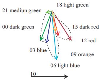
The low level wind maximum experiences variations in intensity during the day. At night, the decoupling of the surface layer from the boundary layer above results in the intensification of the LLJ. This decoupling disrupts the balance between the pressure gradient, Coriolis and frictional forces, creating inertial oscillation of the wind about its would-be equilibrium position. The oscillation leads to super-geostrophic winds and is responsible for the nocturnal low-level wind maximum, as shown in the figure corresponding to the summer diurnal cycle in Asunción, Paraguay (Nicolini et al., 2004).
|
Mean summer diurnal wind gyre (m/s) at Asunción, Paraguay (25°16' S, 57°40' W) at 1000 m asl. UTC times.
|
|
Seasonal and diurnal cycle of the convection
Convection over South America is affected by the seasonal migration of the Intertropical Convergence Zone (ITCZ). In summer, there is an increase in the intensity and frequency of convection over tropical South America. The maximum occurs during the hours of greatest radiational heating over Brazil and the Altiplano, while nocturnal convection develops over the low lands of Bolivia. In winter, due to a decrease in solar heating, there are inversions and less moisture in the troposphere, and convection is scant.
Convection over subtropical latitudes is characterized by a maximum near 32°S-58°W at 12 UTC. This maximum is prominent in spring and less substantial in summer and autumn; in winter it does not exist. There is a difference between Argentina and southern Brazil and Uruguay; in the latter two, the convection is present throughout the day, with maximum activity at night, while over Argentina the convection declines at 18 UTC in all seasons.
In the eastern slopes of the Andes, the maximum of convective activity occurs at 06 UTC. It is more pronounced in summer than in other seasons.
|
Convection frequency (percentual) every 6 hours in spring (SON) (Salio and Nicolini, 2006).
|
Convection frequency (percentual) every 6 hours in summer (DJF) (Salio and Nicolini, 2006).
|
|
|
|
Convection frequency (percentual) every 6 hours in autumn (MAM) (Salio and Nicolini, 2006).
|
Convection frequency (percentual) every 6 hours in winter (JJA) (Salio and Nicolini, 2006).
|
|
|
In summary, convection south of 25°S is clearly linked with the SALLJ. In spring and fall it exhibits a nocturnal maximum over the western and central parts of SESA. In summer there are two phases of maximum convection; one is nocturnal and the other occurs during the afternoon, especially in the eastern parts of the area. The nocturnal convection is initiated by the low-level jet maximum. In the evening the convection is triggered by the solar heating of the surface.
During LLJ-ARG events, there is no diurnal cycle in the convection.
Life Cycle of SALLJ
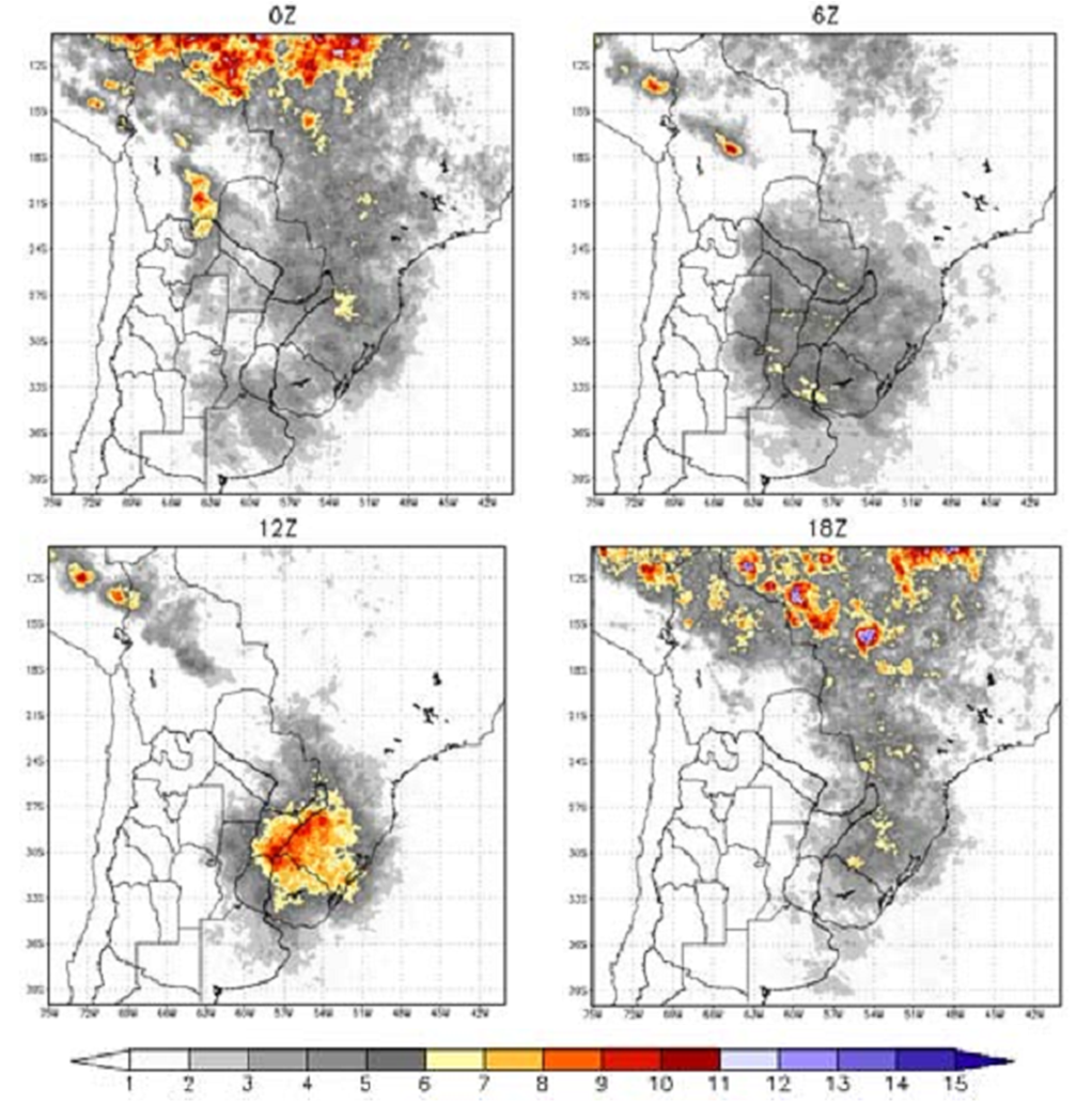
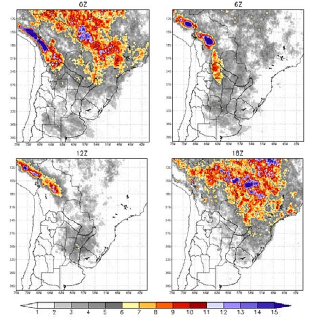
1. Life cycle of the Chaco Jet type
| Day - 1 | |
|
|
| Day - 0 | |
|
|
| Day + 1 | |
|
|
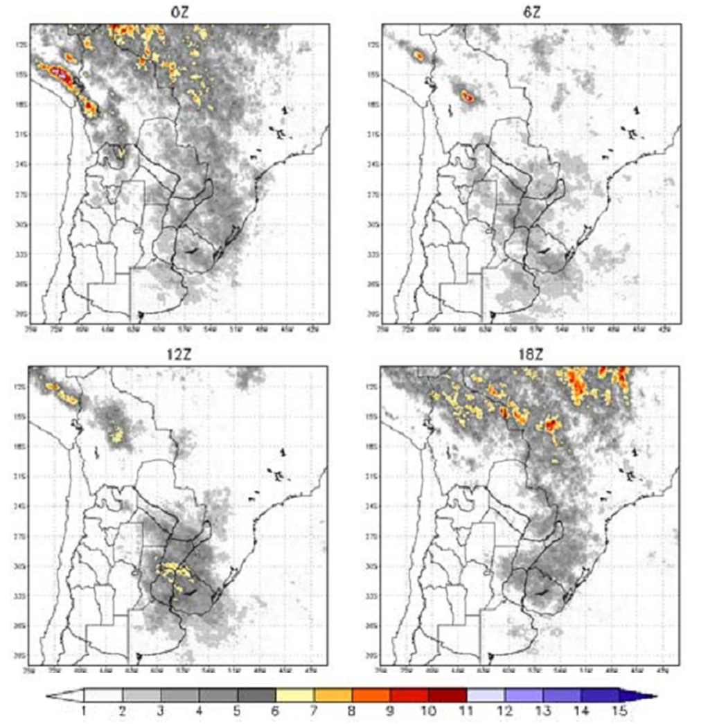
2. Life cycle of the No Chaco Jet type
The synoptic patterns are not as distinct as for the CJE type.
| Day - 0 | |
.png)
|
|
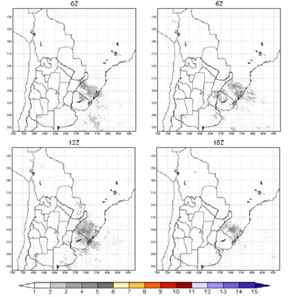
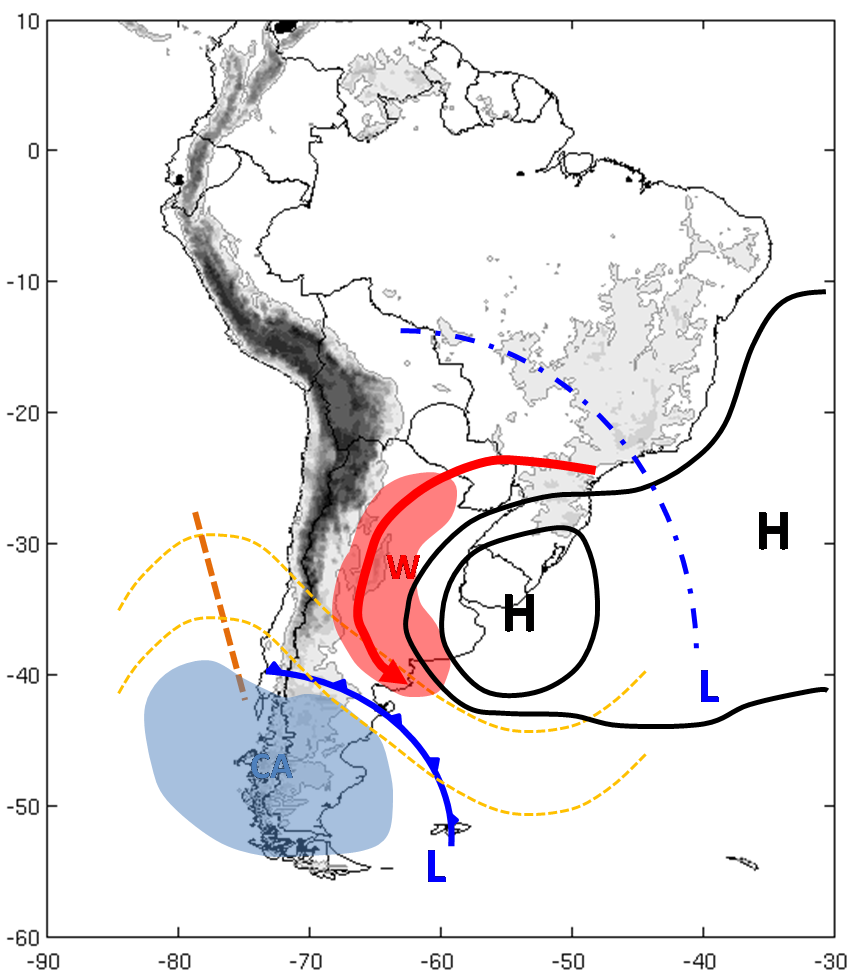
3. Life cycle of the LLJ-Argentina type
| Day - 0 | |
|
|
Connection between SALLJ and the upper-level jet (ULJ) for Chaco Jet events
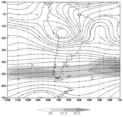
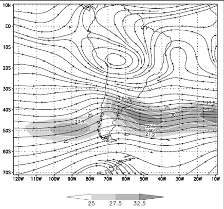
The mean upper level wind field shows a zonal maximum around 50°S. However, for the CJE cases, the ULJ streak shows a more important meridional component with 2 jet streaks: one of them SW-NE oriented upwind of the Andes and the other one downwind with a NW-SE orientation.
|
a) Mean summer high-levels streamlines and wind speed (values greater than 25 m/s are shaded) at 300 hPa. Period: 1979-1993 sum
|
b) Streamlines and wind speed composite (contoured values greater than 25 m/s are shaded) for Chaco Jet events at 300 hPa for summers 1979-1993. Salio et al (2003)
|
|
|
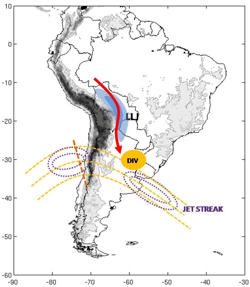
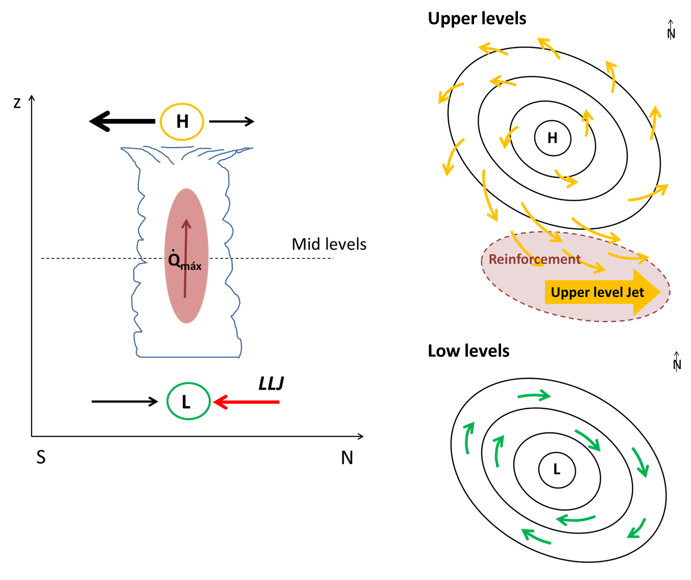
a) Dynamic aspect: secondary ageostrophic circulations
- The ULJ upwind of the Andes decelerates as it crosses the mountains. This favours a meridional indirect ageostrophic circulation on its exit region. Its low level branch, a northerly wind flow, then reinforces the SALLJ. Furthermore, as the upper jet crosses the Andes, the ensuing subsidence on the lee of the mountains induces heating and negative pressure anomalies at low levels. These anomalies are associated to the NAL.
- The NW-SE upper level jet streak produces a direct ageostrophic circulation on its entrance region. The interaction between the low level branch and the LLJ reinforces the convergence at the left entrance region of the ULJ facilitating the development of convection in this area.
|
|
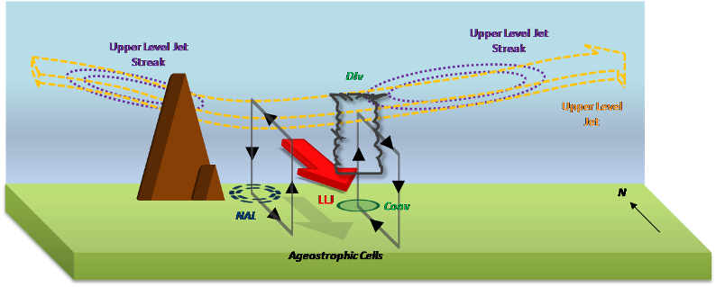
b) Interaction between SALLJ and deep convection
- The low level convergence, as it couples with upper divergence on the right entrance region of the jet maximum (direct ageostrophic circulation), favours and helps sustaining the strong moist convection. Moreover, the LLJ becomes accelerated by the convection itself. These processes facilitate the development of deeper and better organized convection as MCSs in the region.
- In association to this MCS there is an important latent heat release at mid levels that promotes a low pressure anomaly at low levels and divergence at higher levels in response to the geostrophic balance. Consequently, there are 2 meridional transverse circulations: a direct one to the south of the MCS and another indirect cell to the north.
- The low pressure anomaly at low levels generates a cyclonic circulation more intense to the SW due to a greater pressure gradient. This reinforces the southern flow near surface in the direct circulation.
- An anticyclonic circulation appears in upper levels with the southern region flow more intense because the Coriolis force. This flow has an ageostrophic nature and experiments an counterclockwise gyre while it is advected by the upper level jet, which is consequently reinforced.
|
(Saulo et al., 2007)
|
|