Chapter V: Usage of SAF (Satellite Application Facilities) products at high-latitudes
5. Usage of SAF (Satellite Application Facilities) products at high-latitudess
Satellite Application Facilities (SAFs) are specialized centers of excellence for processing satellite data, financed by EUMETSAT. They play a crucial role in providing operational data and software products for various user communities and application areas, ensuring reliable and timely operational services. In the context of high latitude regions, SAFs offer valuable insights and tools that address unique challenges that these regions have in using satellite data.
The most limiting challenge in the high latitudes is the lack of sunlight in the wintertime. Data can contain systematic errors, such as incorrect cloud top height readings in the presence of upper-level inversions (see extra material: herve.pdf). A case where lack of sunlight causes incorrect readings can be seen in Figure 32. In the image the SAF product suggests there is no snow on the ground in Northern Lapland, which is not the case at that time as can be seen by looking at the image on the right. The reason for this is that the solar elevation angle during winter months even during daytime is too low for correct data retrieval in northern parts of Fennoscandia. One can also see discontinuities in the “snow over land” interpretation, which may be due to dense forest and no snow cover on the treetops.
Usage of SAF products, such as those observing land surface, can also be limited due to persistent cloud cover. Snow conditions in winter months can also limit usage of products that observe vegetation or soil moisture. Other challenges that are not limited only to high latitude regions, include topographic variability, which can lead to complexities in data interpretations. More about SAF limitations can be found in the practical guide for forecasters found in the extra material.
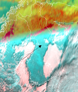
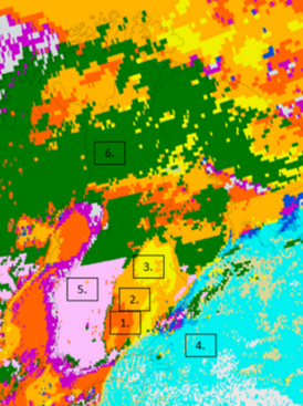
Figure 32: 10:15 UTC: (left) Cloud type SAF, 27 November 2023 The numbers represent: 1. Very low clouds; 2. low clouds; 3. mid-level clouds; 4. high clouds; 5. snow on ground; 6. Cloud-free land without snow. (right) SEVIRI HRV Fog RGB and Night Microphysics RGB. (In the final version images should be placed next to each other, resized)
Another issue associated with SAF products using geostationary data at high latitudes is parallax. Parallax correction might lead to blank spaces in some SAF products because parallax is different for clouds with different top heights. Figure 33b is the same as Figure 33a except with the parallax corrected for. Despite the correction, the image is still very much usable despite the locally abundant CB clouds. Other restrictions on the use of SAF products are listed in the Quick Guides in the list of extra materials.
Use the slider
|
|
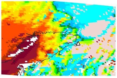
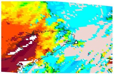
Figure 33a (left) - Nowcasting SAF Cloud Top Height product, no parallax correction (SEVIRI, Meteosat-11): 21 June 2021, 11:45 UTC. The city of Oulu is marked with a triangle. Figure 33b (right) - Nowcasting SAF Cloud Top Height product, with parallax correction (SEVIRI, Meteosat-11): 21 June 2021, 11:45 UTC. The city of Oulu is marked with a triangle.