Hyperspectral data
Hyperspectral data from polar orbiting satellites provide information about the vertical structure of the atmosphere. These instruments measure radiation in several thousands of channels, which is 'translated' into temperature and water vapour profiles. The capability of sounders to detect atmospheric structure is determined by the vertical width of the weighting functions, the noise level and the number of independent spectral channels associated with the radiance measurements. A weighting function, defined as the vertical derivative of the atmospheric transmittance profile, determines the height region that is sensed from space by the radiance measurement at each spectral channel. Given a spectrum of radiance measurements, temperature and humidity profiles and other parameters can be derived using an inverse solution of the radiative transfer equation as part of the so-called inversion problem (i.e., the retrieval of the atmospheric state from atmospheric spectral radiance measurements). Theoretically, a spectrum of infrared radiances at high spectral resolution can be inverted to produce temperature and humidity profiles with a vertical resolution of 1-3 km, dependent upon altitude, and an average accuracy of 1-2 Kelvin for temperature and 10-20% for humidity (Weisz et al, 2015).
Retrieving temperature and moisture profiles from radiance measurements is challenging for the following reasons:
- the inversion problem is underdetermined. A near continuous profile must be retrieved from a finite number of measurements.
- the weighting functions overlap each other (Figure 8), indicating vertical correlation in the measurements. This makes characterisation of the vertical profile at high resolution very difficult.
- all measurements contain noise, which limits the achievable vertical resolution.
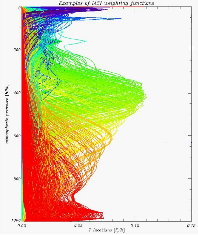
Figure 8: IASI weighting functions (August, 2020)
These issues have to be addressed when temperature and moisture profiles are retrieved. Two different retrieval methods are generally used: linear regression and optimal estimation. Data used in this case study were provided by EUMETSAT, retrieved by a piece-wise linear regression method using IASI measurements on board Metop satellites. More information about this method including validation results can be found here.
Hyperspectral infrared sounder data are also often combined with microwave measurements to cover cloudy areas. NOTE: in infrared spectra we can only retrieve profiles in cloud free areas or above the clouds. The data used here combine IASI measurements with microwave data on board Metop satellites such as AMSU and HMS.
From the retrieved temperature and moisture profiles we can calculate instability indices such as the Lifted Index, K-Index, etc., and Total Precipitable Water. Comparing NWP instability indices to the satellite retrieved data can indicate how reliable our model forecast is, since the satellite profiles are based on the actual state of the atmosphere.