Benefits and limitations
Benefits
- The Cloud Phase RGB provides more reliable separation between thick ice and water clouds than the SEVIRI RGBs do: see the simulation in Fig. 2.6, and examples in Figs. 4.3c, 5.1a, 5.1b and 6.3.
- The Cloud Phase RGB provides good particle size separation for thick clouds, for both water and ice clouds, see Figs. 7.5, 4.2 and 4.3b and c.
- The colour contrast of thick ice clouds with small or large ice crystals at their tops is higher than in the Day Microphysics RGB, see Fig. 5.3.
- The Cloud Phase RGB is useful for convection monitoring:
- Cloud top glaciation during the developing phase is clearly seen, see Figs. 7.2 and 7.3.
- The presence of small particles on (or above) mature mid-latitude, continental thunderstorm tops is an indicator of updraft intensity, and therefore possible severity, see Figs. 7.4a, 7.4b and 4.2.
- As very thin clouds are (almost) not seen, they do not (strongly) interfere with the visual monitoring of the underlying scene, see Fig 6.5.
- Usually, snow-covered surfaces can be distinguished from ice clouds. Although snow-covered surfaces and ice clouds both appear in bluish colours, the snow is usually darker, see Fig. 7.6.
- The Cloud Phase RGB can provide information on snow grain size, see a case study on the EUMeTrain webpage.
Limitations
- Limited to daytime applications.
- Separation of very thin water and ice clouds may be problematic, see Figs. 2.7 and 4.1.
- It does not contain temperature information.
- It is less sensitive to very thin above-anvil cirrus clouds than the Severe Storms RGB, see Fig. 5.4.
Remarks
- Very thin cirrus clouds cannot (easily) be observed, see Fig. 6.5.
- Small ice crystals on the top of thick cloud do not always indicate a severe storm, nor a convective cloud, see Figs. 7.7b and 5.2.
- The colour shades partially depend on solar and satellite viewing angles.
Examples
Figs. 5.1a and b confirm that, for an RGB using NIR1.6 as its only microphysical channel, water clouds with large droplets at their tops can look similar to ice clouds. In Fig 5.1a the Cloud Phase RGB is compared to the Natural Colour RGB, while in Fig 5.1b it is compared to the Day Microphysics RGB.
Fig. 5.1a shows Cyclone Marian in Cloud Phase and Natural Colour RGBs. Many more colours can be seen in the Cloud Phase RGB, which shows that large parts of the cloud system are water clouds. In the Natural Colour RGB, water clouds with large droplets tend to look similar to ice clouds, so almost the whole cyclone appears cyan.
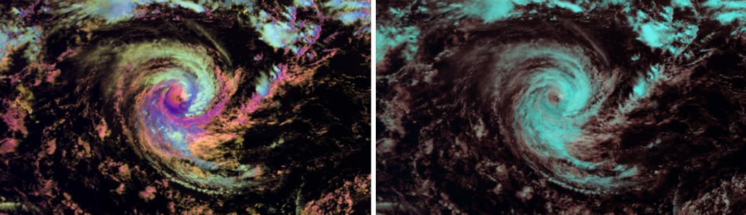
Fig. 5.1a: Cyclone Marian in Himawari/AHI Cloud Phase and Natural Colour RGBs on 03 March 2021 at 06:00 UTC.
The Day Microphysics RGB also uses only one microphysical channel (IR3.7 or NIR1.6) but it also utilises the IR10.8 channel, which provides temperature information. The Day Microphysics RGB is much better for cloud analysis than the Natural Colour RGB, so we are interested in whether the Cloud Phase RGB can identify the cloud phases better than the Day Microphysics RGB.
Fig. 5.1b shows an example where the cloud phases are more clearly recognisable in the Cloud Phase RGB than in the Day Microphysics RGB. The right panel shows a larger area in order to show the overall situation. The left and middle panels show closer views of the frontal cloudiness. The clouds in the ellipse are blue and magenta in the Cloud Phase RGB, indicating two different phases: ice clouds and water clouds covered by extremely large droplets. These two cloud phases cannot be differentiated by the Day Microphysics RGB.
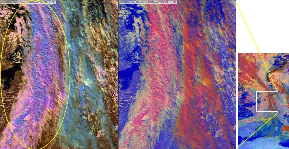
Fig. 5.1b: Left panel: VIIRS Cloud Phase RGB; middle panel: Day Microphysics RGB (created with NIR1.6 on green); right panel: MSG Day Microphysics RGB (created with IR3.9 on green) showing a larger area; 27 September 2021, 11:59 UTC (12:00 UTC for MSG).
Fig. 4.3c provides further evidence: the towering cumulus clouds in the multicell system are magenta and medium blue in the Cloud Phase RGB, but they appear almost the same colour shade (pink/red) in the Day Microphysics RGB (created with NIR1.6).
Ice clouds with very small ice crystals can look like water clouds in some SEVIRI-based RGBs. This is not the case with the Cloud Phase RGB, see Fig. 5.2. In the left panel we see a cirrus shield, heavily polluted by Saharan dust, while the right panel shows high-level lee clouds. In both cases the cloud top ice crystals are extremely small. Although their colours include more yellow shades, they still appear greenish indicating that these are ice clouds.
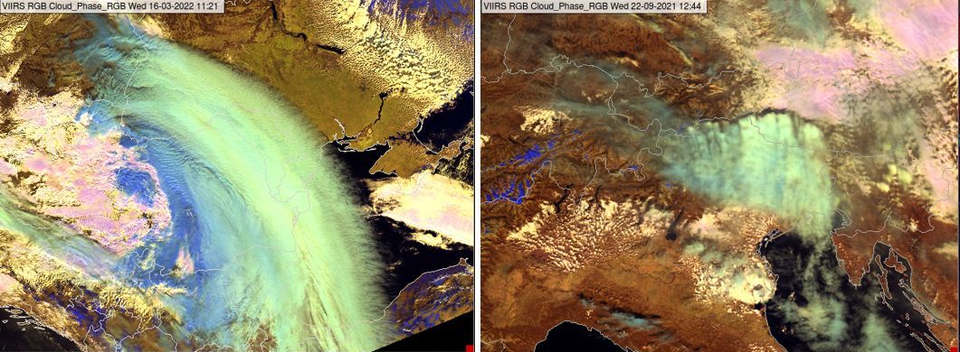
Fig. 5.2: VIIRS Cloud Phase RGBs taken on 16 March 2022 at 11:21 UTC (left) and 22 September 2021 at 12:44 UTC (right).
Figure 5.3 shows an example of the colour contrast, between thick ice clouds covered by smaller and larger ice crystals (see the arrows), being higher in the Cloud Phase RGB than in the Day Microphysics RGB (created with NIR1.6 on green).
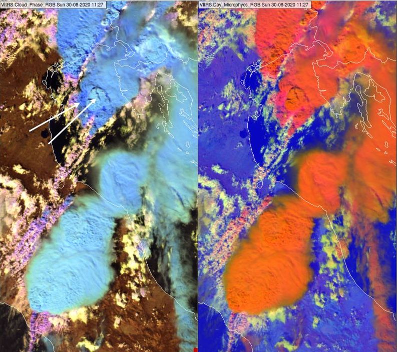
Fig. 5.3: VIIRS Cloud Phase and Day Microphysics RGB (with NIR1.6) on 30 August 2020 at 11:27 UTC.
The Cloud Phase RGB is less sensitive to very thin above-anvil cirrus clouds than the Severe Storms RGB, see Fig. 5.4.
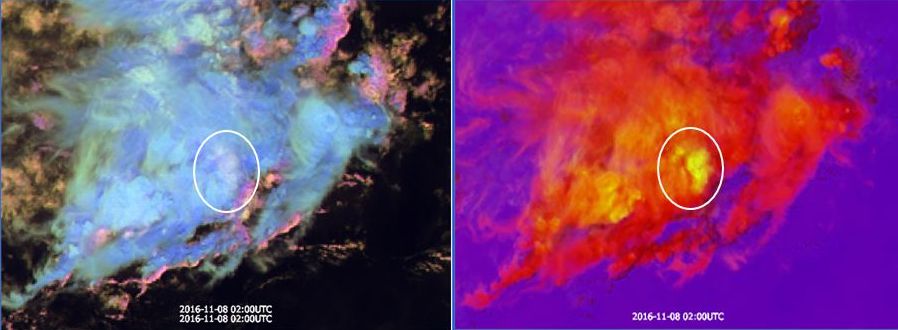
Fig. 5.4: Himawari/AHI Cloud Phase RGB and the tropical version of the Severe Storms RGB on 08 November at 02:00 UTC.