Typical colours
RGB images potentially contain millions of colours. This chapter presents the typical colours of Cloud Phase RGBs with examples. To understand how these colours evolve and how to interpret them, the previous two chapters are needed as they describe the characteristics of the channels and the way they are combined (the two NIR channels are enhanced twice as strongly as the visible channel). Detailed explanations about each typical colour are available in the RGB Colour Guide on the EUMeTrain webpage.
Fig 4.1 summarises the typical colours of the Cloud Phase RGB.
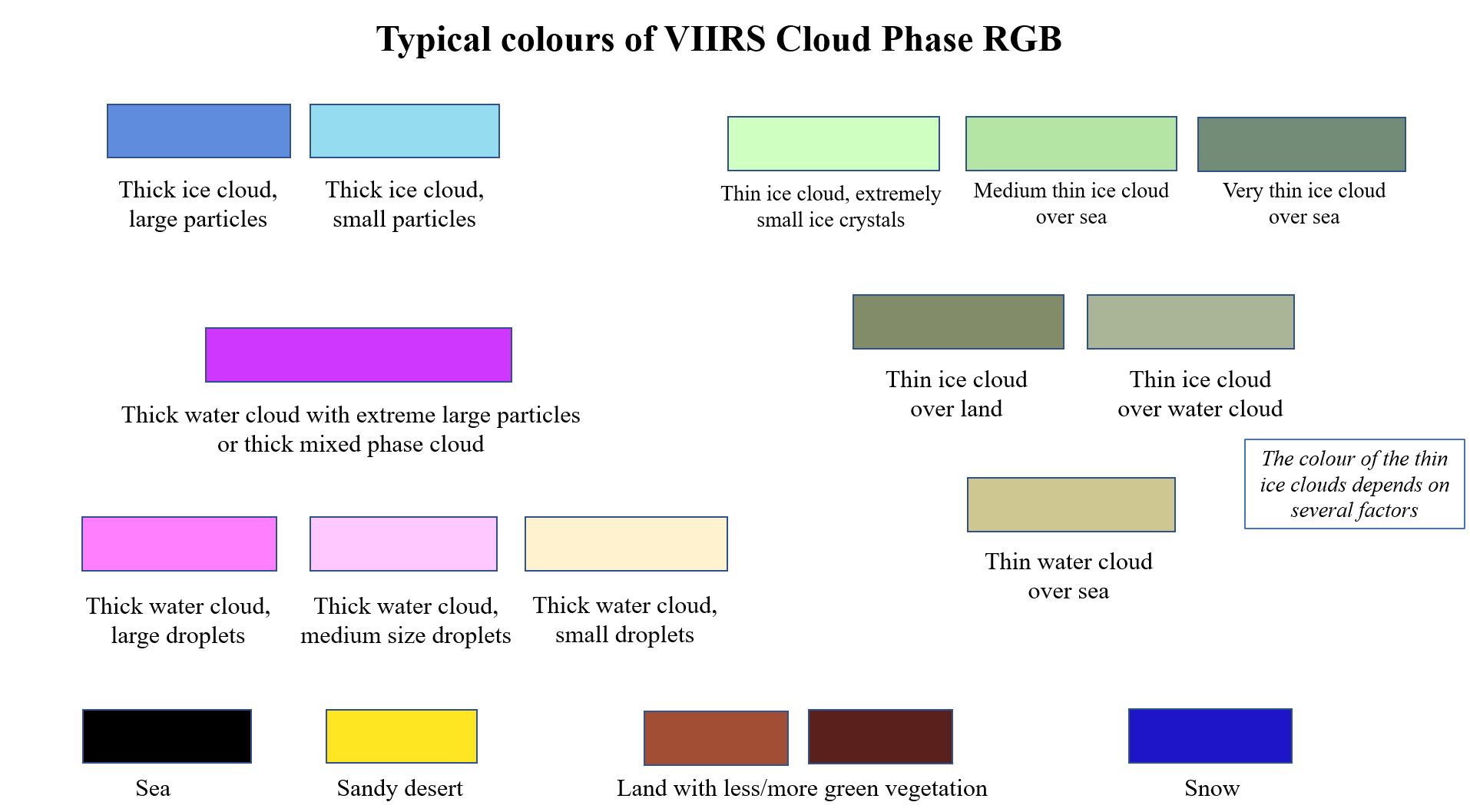
Fig. 4.1: Typical Cloud Phase RGB colours
Thick ice clouds
Thick ice clouds appear in different blue shades in the Cloud Phase RGB, depending on the cloud top mean particle size. In most cases the thick ice clouds are covered by large ice crystals appearing medium blue. However, some exceptions occur when the cloud top ice crystals are small; these appear either light blue or cyan.
Deep convective clouds with strong updrafts (severe convective clouds) often appear light blue or cyan in the Cloud Phase RGB. An example is shown in Fig. 4.2. The reports in the European Severe Weather Database (https://www.eswd.eu/) confirm that the convective cloud systems indicated by arrows caused severe weather during their lifetime (tornado, hail, severe wind gusts).
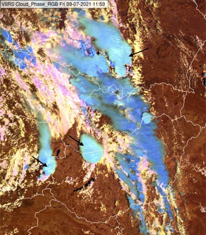
Fig. 4.2: Thick ice clouds covered by large ice crystals (medium blue) and small ice crystals (light blue or cyan) in a VIIRS Cloud Phase RGB from 09 July 2021, 11:59 UTC
Thick water clouds
Thick water clouds appear in different colours depending on the cloud top droplet size. Fig 4.3a shows small isolated cumulus clouds over land in France. These cumulus clouds have small droplets at their tops and appear pale yellow in the Cloud Phase RGB. (Note that over sea mainly thin stratiform water clouds are seen.)
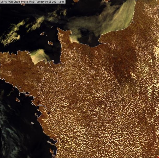
Fig. 4.3a: VIIRS Cloud Phase RGB from 08 June 2021, 12:31 UTC
Figure 4.3b shows fog along the northern coast of Spain. Over land it is mainly thick, appearing in pale yellow and pink colours indicating smaller and larger droplets, respectively, at their tops. Over sea the cloud is partly thin.
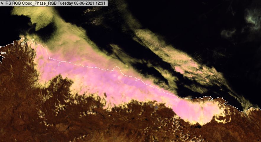
Fig. 4.3b: VIIRS Cloud Phase RGB over norther Spain, 08 June 2021, 12:31 UTC
The left panel of Fig. 4.3c shows multicell systems in a Cloud Phase RGB. To the southwest of the large mature cells one can see the younger cells, the towering cumulus clouds. Some of them are still water clouds. Magenta colours indicate water clouds with extremely large droplets. They might also contain some ice crystals at their tops.
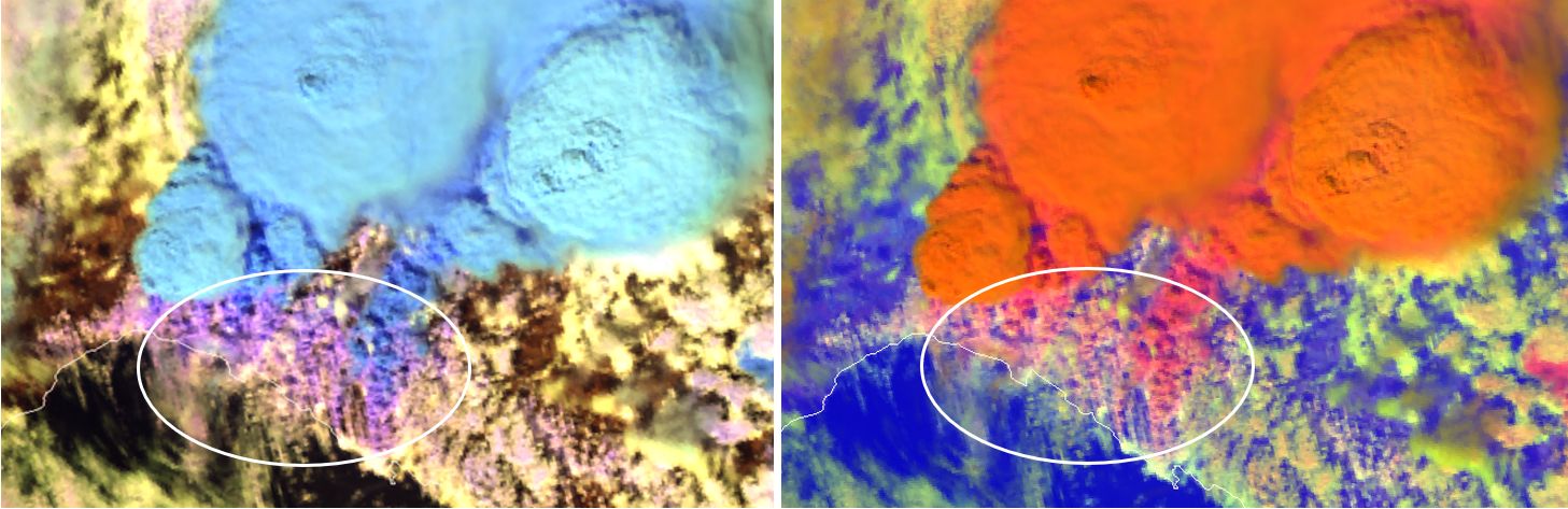
Fig. 4.3c: VIIRS Cloud Phase RGB and Day Microphysics RGBs (with NIR1.6 on green) from 29 August 2020 11:46 UTC
Thin clouds
Thin clouds are transparent: the radiation measured by the satellite originates partly from the cloud (reflected solar radiation) and partly from below the cloud. As a consequence, the colour of a thin cloud depends on several factors. It depends not only on the characteristics of the cloud (e.g., particle concentration, cloud top particle phase, mean particle size, form), but also on its transparency, the reflectance of the underlying surface, etc.
Thin ice clouds in Cloud Phase RGBs usually appear in greenish tones, see Figs. 4.4a and 4.4b.
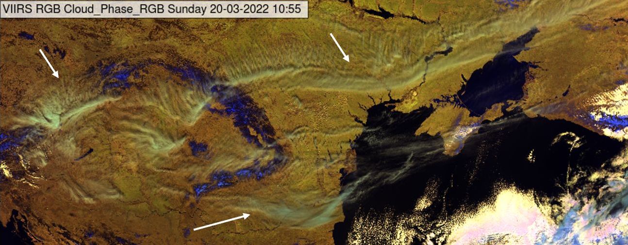
Fig. 4.4a: Thin cirrus clouds elongated from the Carpathian Basin to the Black Sea region. VIIRS Cloud Phase RGB from 20 March 2022, 10:55 UTC
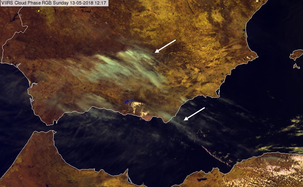
Fig. 4.4b: High-level lee clouds over Spain and the Mediterranean Sea. VIIRS Cloud Phase RGB from 13 May 2018, 12:17 UTC
Thin water clouds usually appear yellowish brown. Fig 4.5a shows thin stratiform water clouds or fog over the English Channel.
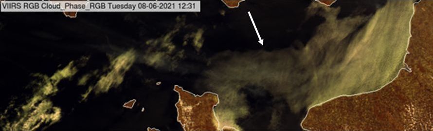
Fig. 4.5a: VIIRS Cloud Phase RGB from 08 June 2021, 12:31 UTC
Fig 4.5b shows cumuliform water clouds over the Black Sea. The arrows indicate the areas where the cumulus clouds are smaller than the pixel size. Here the measured radiation is a mixture of the radiation reflected by the clouds and the sea. These are fractional clouds and in the satellite image they behave similarly to thin clouds.
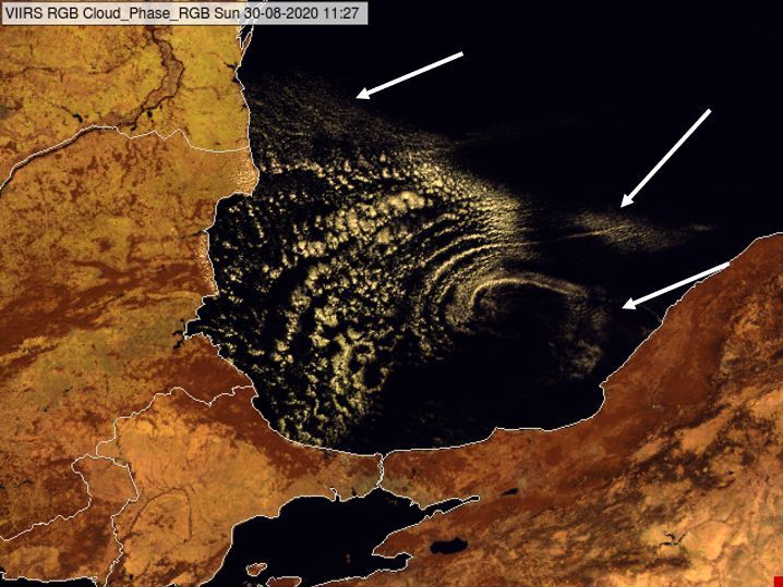
Fig. 4.5b: Cumuliform water clouds over the Black Sea on a VIIRS Cloud Phase RGB from 30 August 2020, 11:27 UTC. The arrows indicate fractional clouds
Could-free areas - vegetated land, desert, sea, snow, fire
Vegetated land appears brown in the Cloud Phase RGB. The shade of brown depends on the vegetation type, the green vegetation fraction and soil type. Denser green vegetation cover appears darker brown. The left panel of Fig. 4.6 shows the Iberian Peninsula in September. Areas with dense green vegetation appear dark brown. Areas where the pixels contain a mix of bare soil and sparse vegetation appear lighter brown with yellowish tones.
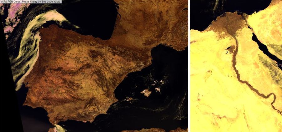
Fig. 4.6: VIIRS Cloud Phase RGB image for 04 September 2020, 12:23 UTC (left) and VIIRS Cloud Phase RGB image for 27 April 2021, 12:10 UTC (right)
Sandy desert appears yellow in the Cloud Phase RGB. Rocky desert (or sand mixed with stones) appears yellow with brownish or reddish shades, or grey. The right panel of Fig. 4.6 shows part of the Sahara with the Sinai Peninsula. The Sahara Desert appears mostly yellow. The vegetated area (e.g., along the Nile River and the delta of the Nile) appears medium brown.
Open water bodies, such as oceans, seas and large lakes (outside the sunglint region) usually appear black in VIIRS Cloud Phase RGBs, see Figs. 4.6 and 4.7. Under some special conditions they can appear dark blue.
Snow-covered cloud-free areas usually appear dark/medium blue. Fig 4.7 shows snow over mountains.
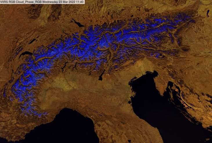
Fig. 4.7: The snow-covered Alps in a VIIRS Cloud Phase RGB taken on 23 March 2022 at 11:40 UTC.
Fires are seen in Cloud Phase RGB images in green to yellow colours, if the fire is sufficiently large, warm and intense, see Fig. 6.6.
Aerosol plumes
The Cloud Phase RGB is not designed for aerosol monitoring. Only sufficiently dense aerosol plumes, with larger particles (e.g., large smoke particles or dust) can be detected and mainly over dark backgrounds (water bodies). Examples of smoke detection are shown in Fig. 6.6. Dense dust cloud is seen in Fig. 7.7b in yellowish brown colour shades. Aerosol plumes have different structures from ice and water clouds. They are smooth, blurred and have washed out colours. Examples of dust detection using Cloud Phase RGB images are shown on the EUMeTrain webpage.
Image interpretation example
To provide an overview of the typical colours for different phenomena, a case is shown with annotations to demonstrate the interpretation of different surface and cloud types in Cloud Phase RGB images (Fig. 4.8).
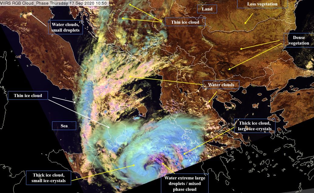
Fig. 4.8: VIIRS Cloud Phase RGB with interpretation, 17 September 2020, 10:50 UTC.