Chapter IV: Convective Initiation
Table of Contents
- Chapter IV: Convective Initiation
- Convective Initiation
Convective Initiation
Geostationary satellites such as Meteosat Second Generation provide observations of developing thunderstorms at high temporal and spatial resolutions. The wide electromagnetic spectrum makes it possible to sense various physical characteristics of convective clouds before they could be detected by radar. The nowcasting method named Convective Initiation relies on this and describes the process where a cumulus cloud evolves from an immature "fair weather" state to a mature cumulonimbus. In the course of this animation we will further explain the process of Convective Initiation and the nowcasting algorithms that help to detect these potential convective clouds.
Imagine a small cloud at time 0. It is characterised by 0 dBZ, and unless you have a truly state-of-the-art radar system, you would not be able to detect it, let alone pay attention to the cell from your work station. In 30 minutes, however, this cell will grow from a small innocent fair weather cumulus into a large cell with a high reflectivity of 35 dBZ.
It will be only at this stage that you would pay attention to it and you probably would wait another 30 minutes to see what the cell will do before you issue a warning to media and public. Convective Initiation would save you this time!
It is only at this stage that you would pay attention to it, and even then you would probably wait another 30 minutes to see what the cell would do before issuing a warning to the media and public. Convective Initiation would save you this time!
For the purpose of a larger evaluation study, the CI algorithm was adapted for MSG SEVIRI channels in the SATCAST algorithm. The SATCAST algorithm is designed to detect initial cumulus clouds which are likely to eventually produce radar echoes greater than 35 dBZ. To achieve this, 17 interest fields are evaluated. They distinguish three features representing physical properties of the growing clouds: cloud depth, updraft strength and cloud top glaciation. In the version of the algorithm used in this study, 14 interest fields must exceed individual thresholds for a nowcast being issued. Since many of these interest fields are based on temporal evolution, it is essential to monitor the same cloud(s) over a time period of 30 min. No tracking or motion vector functionality is available in the present algorithm, so all data is averaged in a box of 7x7 pixels around the target pixel.
The total lightning data (cloud and ground flashes) is used as a proxy for strong convection, since radar data for entire Europe was not available for the study.
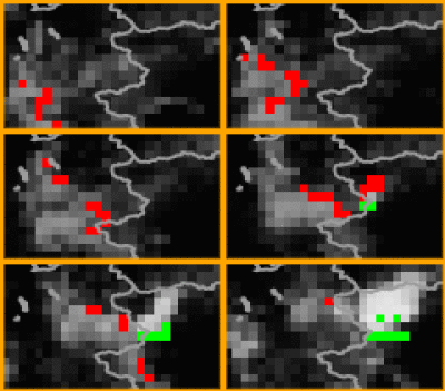
Figure 4.1: Meteosat 9 IR10.8 SATCAST Composite for 25 May 2009.
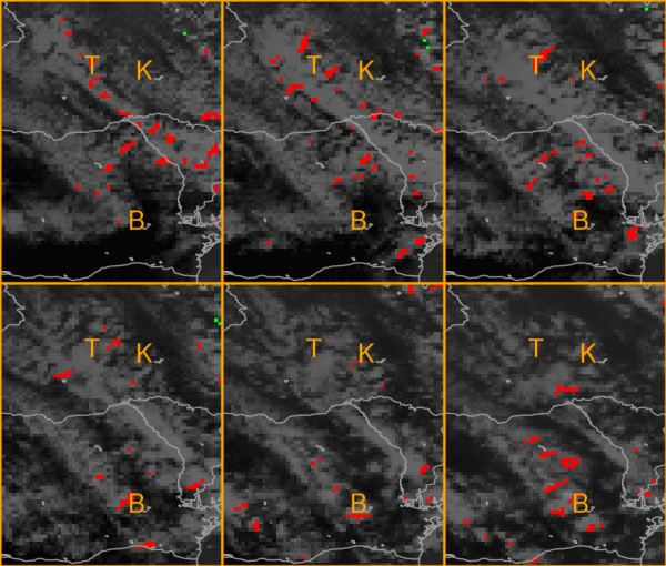
In the MSG composite images above, the following colour coding is applied: pixels in red denote a SATCAST-warning. Warnings are based on data from t, t-1 and t-2, where t is the number of the SEVIRI scan. Green pixels denote lightning in the following hour, meaning 60 min starting from the indicated start of the scan plus 10 min (the approximate scanning time for Europe). So keep in mind that for a developing thunderstorm, green pixels will appear 45-60 min before the actual onset of lightning. Ideally, SATCAST detections should have appeared by then as well. Pixels in which SATCAST and lightning detections coincide are marked in cyan. Please note that the datasets are only considered over land.
In the following, we highlight three different cases: one in which initiation of a later thunderstorm was detected by SATCAST (over France, Italy and Switzerland; case 1), one with a missed storm detection (Austria; case 2), and one false alarm (Ukrain and Romania; case 3). The following text hopes to elicit future improvements of satellite-based CI algorithms.
Case 1 (Hit)

A small band of convective clouds moves in from the southwest. In front of this band a thunderstorm develops over this alpine region. Lightning first occurs shortly after 13 UTC. The first nowcast can be seen in the 1200 UTC image, which would have been transmitted via EUMETCast by 1230 UTC. So in this case the algorithm does provide a usable lead time of some 25-30 min with respect to lightning initiation. This could be improved to 45-50 min if the SATCAST processing were done directly at EUMETSAT upon MSG data reception. The cloud band itself is accompanied by SATCAST detections, but no lightning occurred in it. Two synop stations in the region of the cloud band also reported no precipitation. However, since the terrain is mountainous, we cannot exclude the possibility of small rain showers with radar echoes greater than 35 dBZ nearby.
Case 2 (Miss)

Since the algorithm does not account for cloud motion, it is not surprising to find mismatches between nowcasts and the actual location of the lightning quite frequently. These misses are easily found on a pixel-by-pixel basis. However, on this day we could not find a showcase miss exhibiting lightning without any nowcast nearby in the imagery. What we will demonstrate as a miss is a case in which the first warning came after the first stroke of lightning.
Over central Austria, several thunderstorms developed. The one regarded here first produced lightning around 1220 UTC. There is a SATCAST detection in the 1230 UTC scan. However, this scan covered central Europe at about 1240 UTC - 20 min after the first flash. In the 1215 UTC scan, still sweeping across Europe roughly 5 min after the first flash, and in all the previous scans, there was no SATCAST detection, although convection can be seen in the IR10.8 imagery from at least 1000 UTC on.
Case 3 (False Alarm)

There were several bands of Cu/Sc over eastern Europe which led to many SATCAST detections. On the easternmost edge of the domain, scattered lightning pixels can be seen. However, in the marked area virtually no flashes occurred. Some stations reported no rain, but we cannot definitely exclude the possibility that some of the clouds may have produced rain showers. The cities of Buzau, Khmel (Khmelnytskyi?), Ternopil and Odessa are marked by accordant letters. Synop reports are available from these cities. Of these, only Odessa at the Black Sea coast reported light rain showers at 1030 and around 1600 UTC. The SATCAST detections are mainly triggered at the leading edge of the advected clouds. Therefore, one explanation for those SATCAST detections may be "advective cooling" - that is, the rapid cooling of a SEVIRI-pixel or pixel group by the advection of clouds over warm terrain - which the algorithm then interprets as vertical cloud growth or glaciation. There are a few control steps implemented in SATCAST to mitigate this problem, but it seems that it can still cause some false alarms.
