Chapter II: Synoptic Analysis
Table of Contents
- Chapter II: Synoptic Analysis
- Synoptic Analysis
Synoptic Analysis
On this day the synoptic maps showed conditions favourable for severe thunderstorms over an extensive area.
In Western Europe an upper-level trough moved in from the Bay of Biscay on the 25th, pushing forward an unusually warm humid air mass, covering NE-France, Belgium, Luxembourg and the Netherlands with minimal dew point depressions.
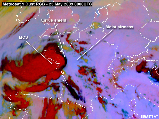
Figure 2.1: Meteosat 9 Dust RGB of 25 May 2009 0000UTC showing the moist airmass over central France in a bluish tone. A positive brightness temperature difference between the channels IR12.0 and IR10.8 used in this RGB indicates high relative humidity. The cirrus shield part of the anvil shows up black in the picture.
The following four images show the Airmass RGB overlaid with the geopotential height at 500 hPa for 25th May 2009 at 00, 06, 12 and 18UTC, respectively. Click your way back and forward to obeserve that a cut-off low with the center over Western Spain slowly connects with a short wave trough travelling in a strong westerly flow over the Atlantic.
Figure 2.2: Meteosat 9 Airmass RGB overlaid with Geopotential Height 500 hPa.
During the course of the day this trough deepens and a blocking situation establishes as a significant ridge of high pressure is building up, stretching from the central Mediterranean to southern Scandinavia. At west side of this omega block a strong southerly flow prevails.
Figure 2.3
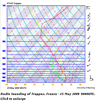
Steep lapse rates, generated by an elevated mixed layer and a moist boundary layer below, were responsible for extreme amounts of convective available potential energy (CAPE) over Western Europe. Additionally, moderate to high amounts of wind shear were in place, emphasising the possibilities for a convective event with large hail (given the high CAPE) and a serious threat of wind gusts (see Fig 2.3).
A long-lived cluster of thunderstorms evolved over the Bay of Biscay during the evening hours of the 24th and entered the western English Channel on the 25th around midnight. After that, the convective cells that developed were smaller due to lacking insolation. On the 25th, in the afternoon, new storms initiated over the northern and western parts of France and across Belgium. A small cluster including a massive supercell crossed Belgium, moving into Germany.
Further initiation took place over central France at roughly 15UTC and this activity organized rapidly into an MCS moving in a northeasterly direction with numerous, discrete supercells ahead of it. Hail around 10 cm in diameter causing widespread damage was reported with these supercells. To the east, another trough stagnated over Eastern Europe, defining a large warm sector with a subtropical airmass reaching far into Central Europe with only a weak high pressure influence. In spite of a strong ridge aloft, we also see some thunderstorms developing in this part of Europe. They appear to be mainly diurnally driven.
The following four links provide you with the satellite images and numerical data in which you can combine the various parameters.
- Satellite Images - 25 May 2009: 0000UTC (+12 hr. Forecast) (Flash material not existing)
- Satellite Images - 25 May 2009: 0600UTC (+18 hr. Forecast) (Flash material not existing)
- Satellite Images - 25 May 2009: 1200UTC (+12 hr. Forecast) (Flash material not existing)
- Satellite Images - 25 May 2009: 1800UTC (+18 hr. Forecast) (Flash material not existing)


