Meteorological Physical Background
The first realistic conceptual model of extratropical cyclones was presented by Bjerknes in 1919, followed by Bjerknes and Solberg in 1922. They put forward the theory that cyclogenesis is associated with the existence of a surface temperature gradient and cyclone intensification occurs when the cold front rotates around the low-pressure center, until it cuts off the warm air and meets the warm front. The importance and influence of upper air phenomena was emphasized by Bjerknes and Solberg in their 1922 theory (figure below).
Cyclones developing near the coasts of Uruguay and southern Brazil are associated at middle/upper levels with a trough or a cut-off low (cold core), which moves from the Pacific to the Atlantic Ocean (as shown in the figure below). These cyclones do not appear immediately after the Andes Mountains. Instead, cyclogenesis occurs approximately 1000 km from the Andes (Vera et al., 2002.).
Factors which create favorable conditions for this development include: a horizontal gradient in the air temperature with warm air temperature over the continent and cold sea-surface temperature (due to Brazilian and Malvinas currents, as shown in the figure below) and moist air on the eastern side of cyclone, with dry air on the western side, combined with the trough or a cut-off low in upper levels.
Sometimes, a surface cyclone can develop when there is warm air advection from the Amazon region in northern Argentina (low level jet) and there is a trough or a cut-off low crossing the Andes (lee cyclogenesis) at upper levels. In both cases the cyclone will then develop and propagate eastwards or southeastwards (figures b and c below). The occlusion phase is generally reached over the South Atlantic Ocean (figure D below).
The cyclones which develop near Uruguay and southern Brazil are slightly different to those described in the conceptual model by Bjerknes and Solberg (1922):
- a) In contrast to the model from these authors, cyclones forming near Uruguay and southern Brazil do not show a surface wave pattern during their initial phase, due to the effects from the mountainous region and from baroclinic instability. Their creation is favored more by the horizontal advection of relative vorticity from a trough or a cut-off low at upper-levels crossing the Andes.
- b) In another contrast to Bjerknes and Solberg's model, cyclones near Uruguay and southern Brazil do not initially display an asymmetric center (cold air in the western sector of the cyclone and warm in the eastern), which then becomes a cold core cyclone during the occlusion stage. Instead, the cyclone center remains warm from its genesis until its decay phase.
|
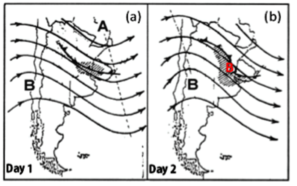
Conceptual model for the development of an extratropical cyclone over South America. The black lines with arrows represent the 500-hPa geopotential high; the black with triangles (semicircles) represent the cold fronts (warm fronts). The bold black letters A and B indicate the position of the high and low-pressure centers, respectively at 500 hPa and the red letter B indicates the surface cyclone position. The shaded areas show the cloudiness associated with the fronts and the cyclone. Source: Adapted from Celemín (1984).
|
|

|
|
Monthly mean sea-surface temperature (°C) over the South Atlantic Ocean from 1982 to 2002. It is possible to identify the Brazil-Malvinas current confluence near the coasts of Uruguay and southern Brazil. Source: Reboita (2008)
|

|
Geographical Location and Seasonal Variety
Extratropical cyclogenesis occurs over two main areas of South America (Gan and Rao, 1992), one of these being Uruguay and the other the San Matias Gulf, Argentina (figure below). During wintertime, the frequency of cyclogenesis is higher over Uruguay than over the San Matias Gulf. In summertime, the opposite is the case. This seasonality is associated with the displacement of the baroclinicity caused by the SST gradients.
Reboita et al. (2010) observed that, during the summertime, there is another region of maximum cyclogenesis frequency beyond these two areas. This third area is located over the coast of São Paulo state (figure below).
Normally, the cyclones form close to the coast (associated with the east coast effect) and propagate eastwards, reaching their maximum intensity over the South Atlantic Ocean. During the period from May to September, many cyclones which form over Uruguay, northeastern Argentina and southern Brazil experience high intensification when they propagate from the continent to the ocean, due to the seawaters being warmer than the surface of the continent. The surface heat flux (latent and sensible) warms the air associated with the cyclone and then often contributes towards intensification of these cyclones.
|
Annual distribution of isolines showing frequency of cyclogenesis. Source: Gan and Rao (1992)
|
Cyclogenesis density from 1990-1999. This density is the number of systems, divided by an area of 5° x 5° of latitude-longitude and multiplied by 104. Source: Reboita et al. (2010)
|
|

|

|