Chapter I: Introduction
Table of Contents
- Chapter I: Introduction
- Introduction
Introduction
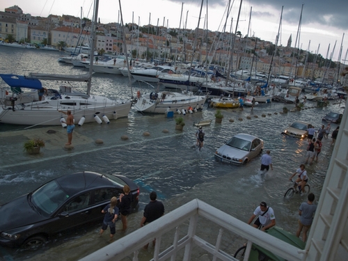
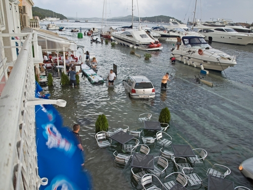
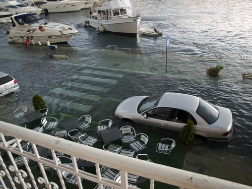
On 15 August 2008, at about 17 UTC, a sea wave flooded the harbor of Mali Lošinj on the island Lošinj in the northern Adriatic. The flood was about 50 to 80 cm high above the ground what, together with the height of the ground above mean sea level, gives the wave height (trough-to-crest) of more than 2 m.

This study is aimed to show that the flooding was caused by a Meteo Tsunami.
What is a Meteo Tsunami?
Meteo Tsunamis are large amplitude sea waves generated by a propagating atmospheric disturbance. They are known in all parts of the world ocean, usually under their local names such as Rissaga in Spain, Milghuba on Malta, Marrubio in Italy and Abiki in Japan. However, their impact to the coastal regions is more pronounced in the low-tidal basin, as the infrastructure is not adopted to the large and rapid sea level variations and associated ocean currents.
Conditions for the generation of such a wave are:
- Strong small - scale atmospheric disturbance
- Propagation of the atmospheric disturbance toward the entrance of a harbor
- External resonance - between the atmospheric disturbance and ocean waves
- Large amplification factor of the harbour of bay
- Internal resonance - between the dominant frequency of the arriving open-sea waves and the harbor mode frequency
It appears from previous Adriatic studies that the speed of the propagating atmospheric disturbance was ~22 m/s to cause the resonance and amplification of the long ocean waves. This speed is dependent on the depth of the basin - sqrt(gravity x depth), which is in the northern Adriatic approximately 50 m. However, the speed may be higher (e.g. around 30 m/s, as estimated for the Balearic meteotsunamis which are being generated over 70-120 m shelf) or lower (e.g. off the coast of Florida) - the important condition is that the speed of the atmospheric disturbance and the speed of the long ocean waves are quite similar!
In Mali Lošinj case the atmospheric disturbance was present in form of a pressure jump, as seen in the microbarogramme:
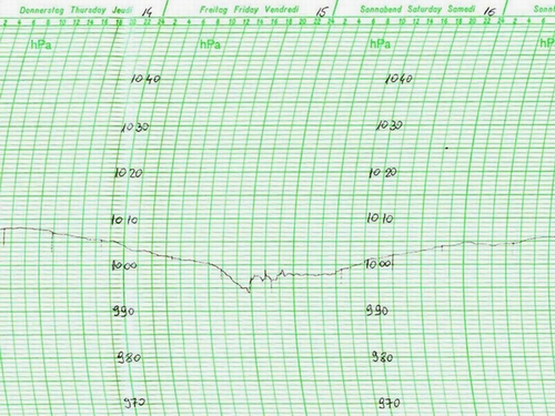
The pressure was falling slowly throughout the day, but then, around 13 UTC it started to fall more rapidly and until 17 UTC it fell for about 5 hPa. Then at 17 UTC it suddenly rose for about 4 hPa.
The question is: What was the cause of the abrupt pressure change?
To answer this, meteorological set-up of the case is presented.