Chapter I: Introduction and motivation
Table of Contents
- Chapter I: Introduction and motivation
- Introduction
Motivation
Hurricane season usually starts in June and lasts until November, so it was not particularly strange for a hurricane to form in the North Atlantic basin on October 9th 2017, especially in such a plentiful year.
Ophelia was the tenth and last hurricane of the season. However, almost all other variables were unusual:
It was formed after a passage of a cold front over the Atlantic (at 31.1 °N and 39.9 °W), where the surface temperature is usually not high enough for hurricane development. It lingered there for a couple of days before continuing northeast. The maximum strength of the hurricane was category 3, but it reached landfall on Ireland as an extra-tropical storm.
The storm was well tracked and the Met Éireann issued warnings on time, so the casualty number was low (three reported deaths), however the infrastructural damage was significant. The damages were no surprise since the maximum mean wind speed was around 100 km/h, gusts up to 190 km/h. A gust of 191 km/h was recorded at the Fastnet Rock, the most southerly point of Ireland. The waves were recorded up to 18 m tall.
There is some indication that the number of hurricanes reaching so far north could increase with a changing climate, therefore it is important to get acquainted and prepared for such a possibility.
Historical data
In Figure 1. we can see all recorded tropical cyclone tracks in the Pacific since 1949 and Atlantic oceans, from 1949-2015, and 1851-2015, respectively since 1851 until 2015.
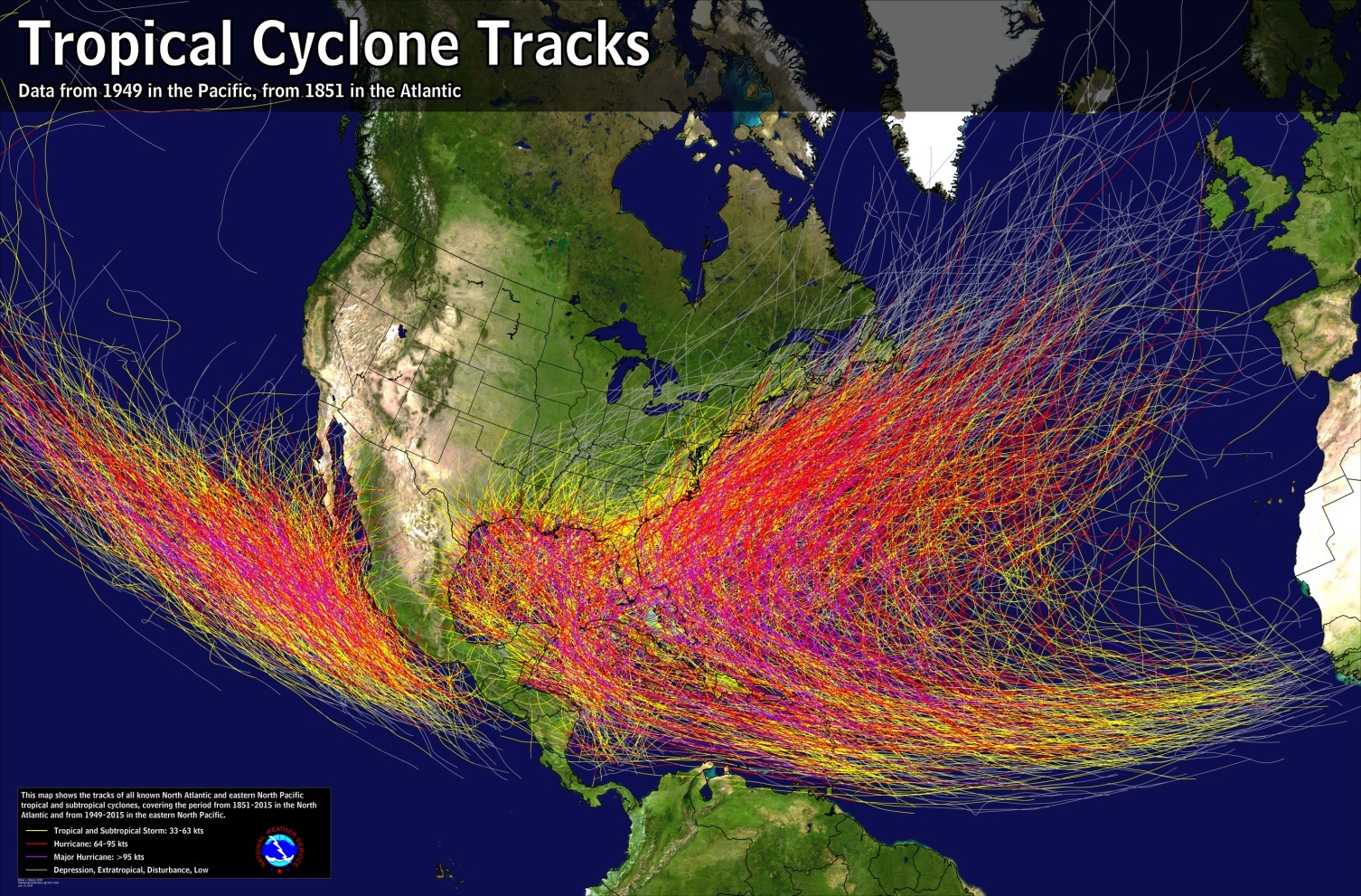
Figure 1: Source: NOAA, National Weather Service
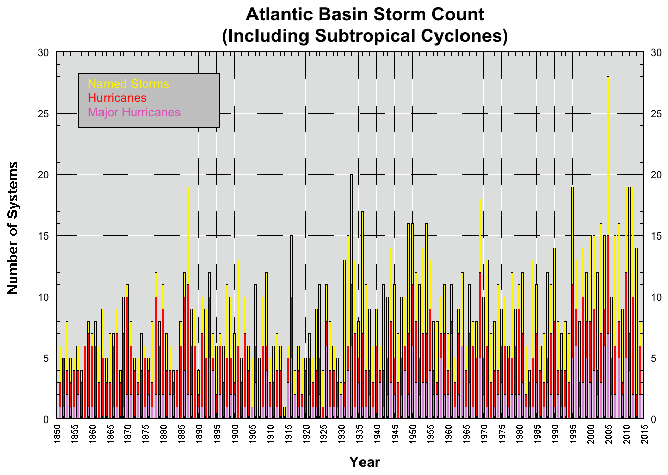
Not only has the number of hurricanes increased throughout the years (https://www.nhc.noaa.gov/climo/images/Atlantic_Storm_Count.jpg ), but there is also an increase in the number of those moving towards Europe (Figure 2). Criteria for potentially dangerous hurricanes for Europe were defined as those whose trajectory was further east than 15 °W and further north than 35 °N.
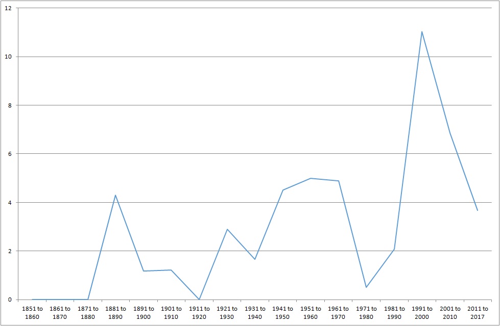
Figure 2: Number of hurricanes per decade that travelled towards Europe. Since hurricanes are relatively rare phenomenon they are grouped in decades.
Conditions for hurricane development
The life cycle of a hurricane starts with deep convection over a warm ocean surface. For a convection to start in a moist, rich environment, there is a need for a trigger; and for it to continue to grow and develop, a constant source of energy is required. A warm ocean surface provides this needed energy in the form of latent heat.
For deep convection to develop into a hurricane, the following conditions need to be met:
- Latitude is between 8° and 20° N/S of the Equator
- High relative humidity (50-60 %) in the mid-level atmosphere (700 - 500 hPa)
- Weak wind shear (values less than 16 m/s)
- Sea surface temperature ≥ 26.5 °C
- Great conditional instability (typically measured as the difference between the equivalent potential temperature, at the surface and 500 hPa, - instability must be > 10 K for convection to occur)
- Strong vorticity in lower atmospheric levels (>20 x 10-5 s-1)
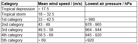
Even if all the conditions are satisfied, tropical cyclogenesis is not guaranteed. Hurricane activity for the current year in the Atlantic Ocean is calculated each year in April and is shown in Table 1.
Table 1. Hurricane categories according to Saffir-Simpson
Hurricane season in the North Atlantic begins in mid May and lasts until mid-November, with the peak at the end of August and beginning of September.
Triggers for hurricane development
For hurricane development there are three significant synoptic situations that sustain convergence and trigger convection:
- Intertropical convergence zone (ITCZ) - located close to the equator, and is rich with convection, where trade winds from the Southern and Northern hemispheres converge. When such a storm escapes above 8 °N/S of the Equator it has the potential to grow into a hurricane
- Convergence along warm and cold front. Heavy and cold air can help warm air lifting along the front. Sometimes such a system reaches the Gulf of Mexico or the east coast of the United States of America and develops into a hurricane
- African easterly waves are atmospheric waves that travel over the Atlantic Ocean. They cause 60% of hurricanes and tropical storms. However as much as 85% of major hurricanes were caused by easterly waves
Hurricane lifecycle
For a tropical storm to develop into a hurricane there is a need for constant energy inflow, high moisture, a warm ocean, and conditional instability. For an easier hurricane understanding the processes can be viewed as Carnot heat engine (Emanuel 2005a). In this case, the hurricane is a closed system, which is not entirely true:
The air at the top of the hurricane is thrown high into the stratosphere, but we can imagine it comes back to the surface very far away from the eye of the storm. With this approximation we can calculate the maximum possible wind speed and predict hurricane category. Stronger hurricanes are more stubborn and feel the surrounding influence of movement of air less than the weak ones, which makes them long lasting and potentially more dangerous.
In the first approximation, the hurricane path is along the atmospheric currents. For better understanding the best would be to look at the whole atmospheric depth and consider that the air is denser at lower levels so the values should have more weight. There is also a "beta stream" that forms around the hurricane which pushes the hurricane toward northwest at a speed up to 2 m/s.
Once the storm is cut off from its heat source it will soon weaken and die. This happens when it reaches the land or other cold surface. It is worth noting one of the reasons why there is such a scarce number of hurricanes higher than 20 °N/S of the Equator is due to high pressure systems above these latitudes. Warm and dry air descends creating inversion and very stable weather conditions.