Chapter VIII: Online Available LST Databases
Table of Contents
- Chapter VIII: Online Available LST Databases
- Land Surface Temperature from MODIS-Aqua & MODIS-Terra
- Global maps of averages of Land Surface Temperature from MODIS
- LST from the EUMETSAT Satellite Applications Facility on Land Surface Analysis
- Copernicus global maps of Land Surface Temperature from a constellation of geostationary satellites
- LST from GEO and LEO instruments - ESA's GlobTemperature
Online Available LST Databases
Some operational LST products are freely available online. In most cases only an online registration form needs to be filled to have access to the products.
Some of the most well-known LST products available online are listed below.
Land Surface Temperature from MODIS-Aqua & MODIS-Terra
LST products from MODIS satellites are available from 2002 onwards at several spatial and temporal resolutions (table II) from the Land Processes Distributed Active Archive Center (LP DAAC) managed by the NASA Earth Science Data and Information System (ESDIS) project. Fig. 30 presents an example of LST from MODIS on 21 June 2003.

Fig. 30: MOD11A1. Acquired 21 June 2003. Tile H17V05. Strait of Gibraltar.
File format is HDF.
Products available: HERE
Information and images were obtained from https://lpdaac.usgs.gov/ maintained by the NASA EOSDIS Land Processes Distributed Active Archive Center (LP DAAC), USGS/Earth Resources Observation and Science (EROS) Center, Sioux Falls, South Dakota.
Global maps of Land Surface Temperature composites from MODIS
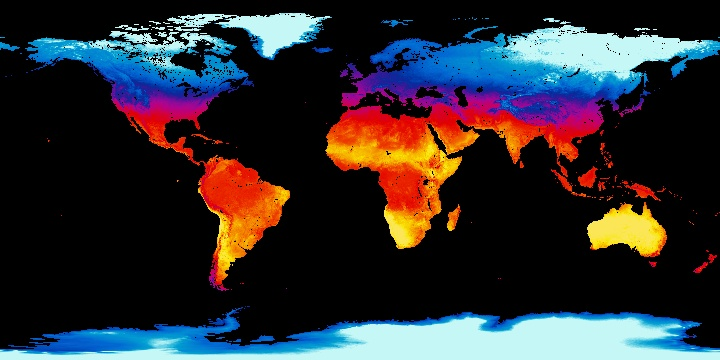
Fig. 31: Average monthly daytime land surface temperatures for December 2001 from MODIS. Source: http://neo.sci.gsfc.nasa.gov/view.php?datasetId=MOD_LSTD_CLIM_M
Instrument:Moderate Resolution Imaging Spectroradiometer (MODIS) on board the Terra satellite
Target accuracy: 1 K
Algorithm: Generalized split-window
Spatial coverage: global
Temporal frequency: Daytime and nighttime LSTs composites. 8 days and monthly daytime or nighttime LST composite products are also produced by averaging daily daytime or daily nighttime LST values, respectively.
Spatial resolution: 1 km
Projection: Stereographic
File format: JPEG, PNG, Google Earth, and GeoTIF
Archive data: 2001-2010
Data producers: MODIS team
Products available at http://neo.sci.gsfc.nasa.gov/view.php?datasetId=MOD_LSTD_CLIM_M
LST from the EUMETSAT Satellite Applications Facility on Land Surface Analysis
The EUMETSAT Satellite Applications Facility on Land Surface Analysis (LSA SAF) produces LST maps from SEVIRI sensor on board MSG each 15 minutes
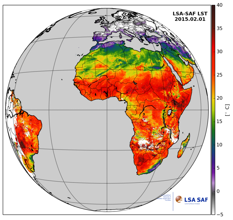
Fig. 32: Daily composite map of LSA SAF LSF for the 1 Feb 2015
Instrument: SEVIRI on board MSG satellites
Target accuracy: 2 K
Algorithm: Generalized split windows
Spatial coverage: MSG-Disk
Temporal frequency: 15 min.
Spatial resolution: 3 km subsatellite point
Projection: GEOS
Archive data: yes (since 2005)
File Format: HDF5
Data producers: EUMETSAT Satellite Application Facility (SAF) on Land Surface Analysis (LSA)
Products available at http://landsaf.ipma.pt/
Copernicus global maps of Land Surface Temperature from a constellation of geostationary satellites
Within the framework of the Global Land Service, the LST product was developed to increase the area coverage of the LST product currently distributed by LSA SAF. A near global product is obtained by merging SEVIRI (i.e., LSA SAF product) with GOES- and MTSAT-based LST.
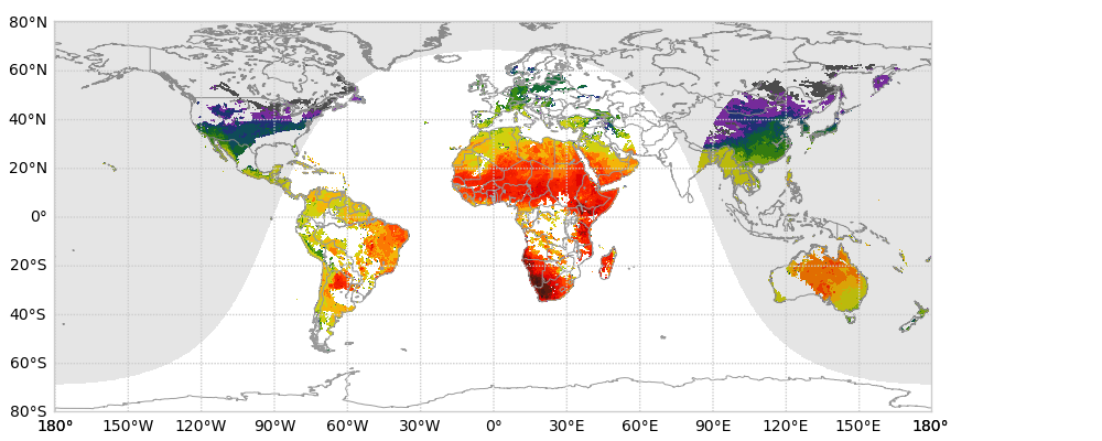
Fig. 33: LST merged product from GOES, MSG and MTSAT satellites developed for the Copernicus Global Land Service.
Instrument: MSG, MTSAT, GOES
Target accuracy: 2 K
Algorithm: For MSG (SEVIRI) the LSA SAF Generalized Split Window algorithm is used. For MTSAT and GOES, a two-channel algorithm is applied to measurements from one MIR and one thermal window (TIR) channel during nighttime, and a mono-channel method requiring a single thermal window channel is used during the day.
Spatial coverage: MSG, GOES and MTSAT disks
Temporal frequency: 1 hour
Spatial resolution: 1 km
Projection: fixed grid map
File format: hdf5
Archive data: 2009-present
Data producers: IPMA-GIO
Products available at http://land.copernicus.eu/global/products/lst
LST from GEO and LEO instruments - ESA's GlobTemperature
GlobTemperature is an ESA project that provides access to multipurpose satellite-based land, lake and ice surface temperature data sets in a harmonized format through a single web portal.
Instruments: AATSR (Advanced Along Track Scanning Radiometer), ATSR2 (Along Track Scanning Radiometer 2), SEVIRI (Spinning Enhanced Visible and Infrared Imager), SSM/I (Special Sensor Microwave/Imager Radiometer).
Spatial coverage: Low orbit derived products have global coverage whereas LST from SEVRI is limited to the MSG disk area.
Projection: fixed grid map
File format: NetCDF-4 CF-Compliant "Harmonised Format"
LST products made available via the GlobTemperature Data Portal
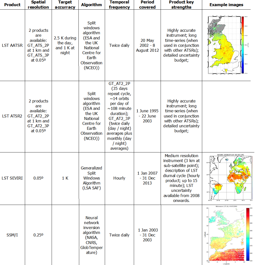
Products available at http://data.globtemperature.info/