Chapter IV: Night Microphysics RGB
Table of Contents
- Chapter IV: Night Microphysics RGB
- Physical basis
- Creating Night Microphysics RGB images
- Typical Colours of Night Microphysics RGB images
- Examples of interpretation
- Benefits and limitations
- Exercise
The aim of this RGB type is to distinguish fog and low clouds from cloud-free areas at night. This is very important for traffic security. Fog or stratus usually forms at night by radiation cooling, and since in-situ observations are rare, satellite information is vital.
At night two RGB types are useful for this purpose: the Night Microphysics and the 24 hour Microphysics RGBs. The colour contrast between surface and low clouds or fog is better in the Night Microphysics RGB images, but unfortunately during daytime and twilight this RGB type is not usable.
Although the main goal is the detection of fog and low clouds, the Night Microphysics RGB reveals also other types of clouds.
Physical basis
Which channels are useful for nighttime fog or low cloud detection?
At night only infrared (IR) channel data is usable. Since we are interested in low clouds, only the "atmospheric window" IR channels are useful. (In an "atmospheric window" channel the absorption of the gas molecules is low.) For cloud-free surfaces and opaque clouds the measured signal in the atmospheric window channels depends mainly on the temperature of the measured object (sea, land, cloud top). The signal also depends on emissivity, as well as slightly on atmospheric effects. For semitransparent clouds the interpretation of the measured radiation is more complicated.
The 'traditional' 10.8 micrometer channel (IR10.8) is included in the Night Microphysics RGB because it separates the thick clouds according to their cloud top temperatures. However, for our purposes one channel is not enough. Using only one single IR channel, the detections of two cloud types are problematic:
- It is difficult (or impossible) to separate fog or low water clouds from the surrounding cloud free surface as their temperatures are close to each other. Fog and low clouds can be mistakenly detected as cloud-free areas.
- It is difficult (or impossible) to separate semitransparent clouds from opaque clouds. On a single IR channel a semitransparent cloud looks like a thick, warmer cloud.
The problems above could be solved by analyzing the following brightness temperature differences:
- The (IR12.0-IR10.8) difference helps to distinguish thick and thin clouds.
- The (IR10.8-IR3.9) difference helps to solve both problems mentioned above.
These differences are used in the Night Microphysics RGB together with the IR10.8 channel.
Separation between cloud free surface and fog or water clouds
The technique is based on two facts:
- The emissivity values of the water clouds and the surface are about the same in the IR10.8 and IR12.0 channels. As a consequence, water clouds are hard to detect in IR10.8 and IR12.0 images.
- The emissivity values of the water clouds and the surface differ slightly in the IR3.9 channel. As a consequence the fog or stratus is not well seen in the IR3.9 images either, but still a little better than in the IR10.8 or IR12.0 channels.
The difference between water cloud and the surface will be more pronounced in the (IR10.8-IR3.9) difference image. The difference will be high for water clouds (or fog) and small for cloud-free surface.
Detection of semitransparent cirrus clouds
Cirrus clouds consist of ice crystals and are often semitransparent. In case of thin clouds some part of the radiation coming from below goes through and so the radiation reaching the satellite is a 'mixed radiation': the brightness temperature is higher than the real temperature of the cirrus clouds. The more transparent the cirrus cloud, the higher the resulting brightness temperature. The brightness temperature of a semitransparent cloud depends mainly on its real temperature, its transparency and the temperature of the underlying surface.
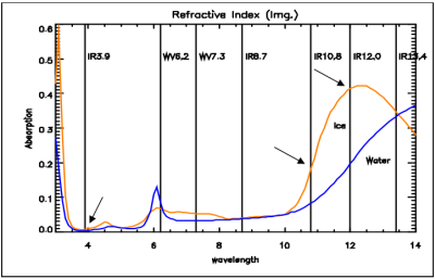
For semitransparent clouds the BT difference of two channels depends strongly on the transmissivity difference. The transparency of thin ice clouds is considerably different around 3.9, 10.8 and 12.0 micrometers, as the ice's absorption is rather different at these wavelengths (see Fig. 1). Thin cirrus clouds can be detected by the (IR12.0-IR10.8) and (IR10.8-IR3.9) differences (large negative differences).
| Figure 1: Absorption spectra of water (blue curve) and ice (orange curve) (Source: MSG Interpretation Guide, EUMETSAT) |
|
Creating Night Microphysics RGB images
The 'recipe' of the Night Microphysics RGB is summarized in Table 1. It shows which channels or channel differences are visualised in which colour. The measured values should be first calibrated to brightness temperatures. The channels or channel differences should be then enhanced - linearly stretched - within the brightness temperature ranges shown in the table.
Table 1: 'Recipe' of the Night Microphysics RGB
| Colour beam | Channel | Range [K] | |
|---|---|---|---|
| Red | IR12.0 - IR10.8 | -4 | +2 |
| Green | IR10.8 - IR3.9 | 0 | +10 |
| Blue | IR10.8 | +243 | +293 |
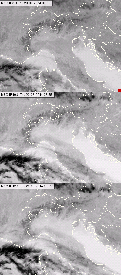
The following example shows how the Night Microphysics RGB is combined from the three IR channels. Fig. 2a shows the three IR channels separately as single channels, all enhanced in the 243-293 K brightness temperature range. Usually the IR images are visualized in the grey scale by assigning bright shades to cold and dark shades to warm objects. However, in Fig. 2a the warm objects (surface, warm clouds) are bright and the cold clouds are dark. The colder the object, the darker it is in these images.
In Fig. 2a the Po valley was coved by fog. This fog is not seen in the IR10.8 and IR12.0 images. In the IR3.9 image one might suspect the presence of the fog. As mentioned, the transparency of cirrus clouds is dependent on wavelength; see for example the thin cirrus clouds across the Apennines. They are the least dark (the most transparent) in IR3.9 image and the darkest (the least transparent) in the IR12.0 image.
| Figure 2a: IR3.9 (up), IR10.8 (middle panel) and IR12.0 (below) images for 20 March 2014 at 03:55 UTC |
|
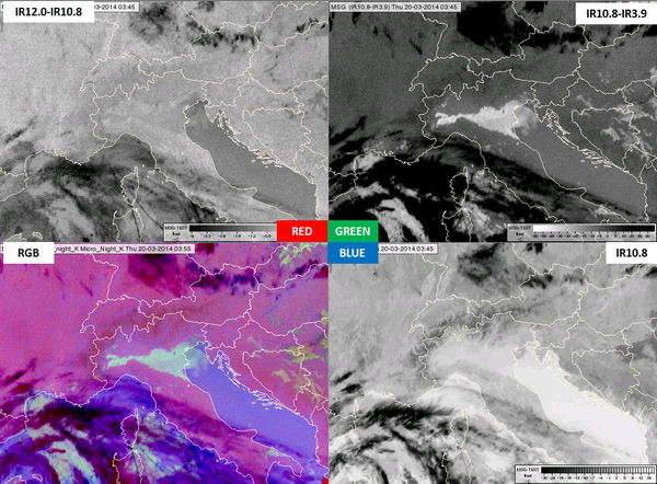
Fig. 2b shows the colour components of a Night Microphysics RGB image: the channel (differences) which are in the recipe with the corresponding enhancement. The lower left panel shows the Night Microphysics RGB.
- In the (IR12-IR10.8) difference image one can easily recognize the semitransparent clouds in the dark shades. However, the fog in the Po valley is not recognizable. The thick water or ice clouds are similar to the surface in this image.
- In the (IR10.8-IR3.9) difference image the surface is medium gray, the water clouds (fog) are much brighter, while the thin ice clouds are dark. The fog in the Po valley has an excellent contrast against the cloud free area.
| Figure 2b: IR12.0-IR10.8 (upper left), IR10.8-IR3.9 (upper right), IR10.8 (bottom right) and the Night Microphysics RGB (bottom left) images for 20 March 2014 at 03:55 UTC |
|
Typical colours
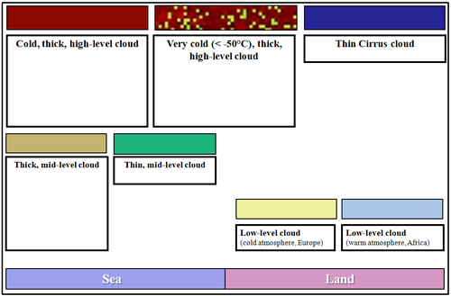
Fig. 3 shows the typical colours of the Night Microphysics RGB images.
- The colours of the clouds depend on the cloud top temperature, cloud top phase and cloud thickness (transparency).
- The colours of the cloud free surface depend on the surface temperature and the moisture content of the atmosphere
| Figure 3: : Typical colours of the Night Microphysics RGB (Source: Jochen Kerkmann, MSG Interpretation Guide, EUMETSAT) |
|
The typical colours of the clouds are as follows:
- Low-level water clouds in mid-latitude are light greenish or yellowish. Thicker water clouds appear in stronger green tones. Warmer water clouds top are depicted in more blue tones. (Warm water clouds over Africa are greyish blue.)
- Thick mid-level clouds appear slightly brownish.
- Thin mid-level clouds appear green.
- Thin semitransparent ice clouds are dark blue, or bluish. The actual tone depends on several factors, like the transmissivity of the cloud and the colour of the underlying surface.
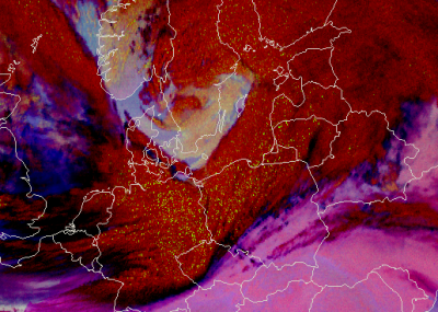
- Thick ice clouds are brownish red. However, if the top of a thick ice cloud is very cold - below -50 °C - greenish dots appear on their tops (Fig. 4). These 'noisy pixels' have similar colours to thick water clouds, but it is important to remember that cold, thick cloud top with green dots means it is very cold, not that there are warm water clouds in some pixels! What, then, causes the 'green dots' feature? For very cold thick clouds the measured radiation is almost zero in the IR3.9 channel, and the retrieved IR3.9 brightness temperature is noisy.
| Figure 4: Night Microphysics RGB for 15 March 2014 at 02:25 UTC. The green dots on the brownish red cloud top indicate very cold cloud top. |
|
The typical colours of the cloud-free surface depend on the surface temperature and the moisture content of the atmosphere, especially on low-level moisture content.
The colour difference is usually due to the different temperature. At night the sea is usually warmer than the land, so
- the sea usually appears bluish, while
- the (non-deserted) land usually appears pinkish.
However, the colour of the cloud-free surface depends not only on the surface temperature, but on the atmospheric low-level moisture content as well:
- moist areas appear more bluish, while
- dry areas appear more pinkish.
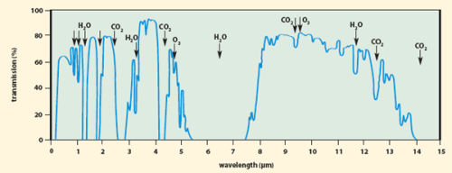
In cloud free regions both the (IR12-IR10.8) and the (IR10.8-IR3.9) differences depend on atmospheric moisture content. A cloud-free atmosphere is more transparent around 3.9 µm than around 10.8 µm, and it is more transparent around 10.8 µm than around 12.0 µm, see Fig. 5. If the moisture content is higher, the red and the green components of the surface will be lower, so the mixed colour will appear more bluish.
| Figure 5: Atmospheric transmission spectra (Source: http://www.photonics.com/EDU/Handbook.aspx?AID=25132) |
|
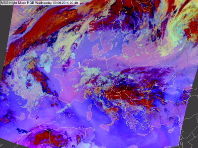
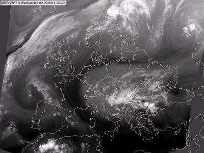
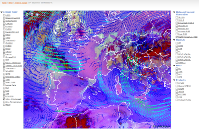
Fig 6a shows an example when the effect of the moisture content is clearly seen in the Night Microphysics RGB image. The structure of bluish and pinkish tones over the Mediterranean and north of Germany and Poland reflect the effects of the atmospheric moisture. For comparison, see the WV7.3 image in Fig. 6b, which shows the mid-layer moisture content of cloud-free areas. Fig. 6c shows the Night Microphysics RGB image from three hours later overlaid with ECMWF 10 m wind analyses. The northerly flow pushes much drier air from France over the Mediterranean, causing the observed moisture pattern over the sea.
| Figure 6a: Night Microphysics RGB for 3 September 2014 at 20:40 UTC |
|
| Figure 6b: WV7.3 image for 3 September 2014 at 20:40 UTC |
|
| Figure 6c: Night Microphysics RGB overlaid by ECMWF 10 m wind vectors analysis for 4 September 2014 at 00:00 UTC (Source: EUMeTrain, e-port) |
|
Examples of interpretation
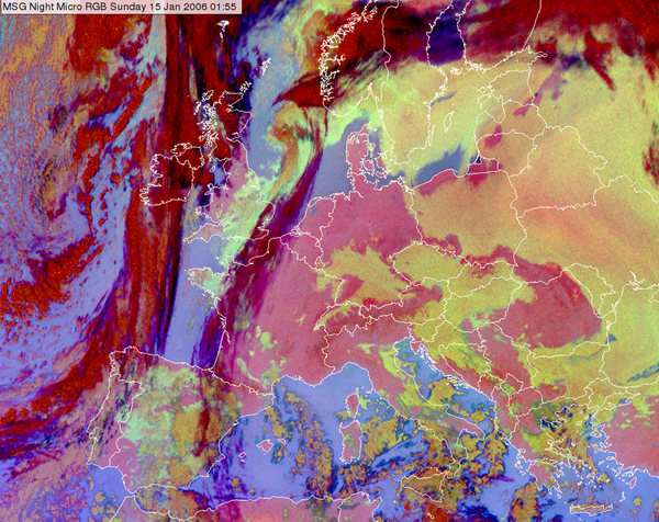
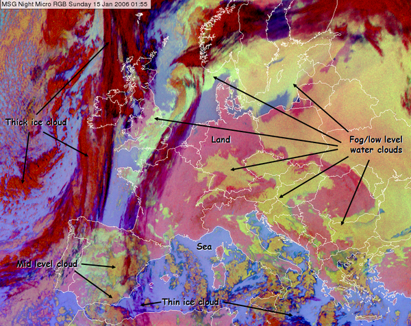
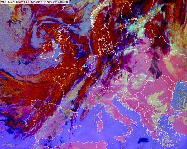
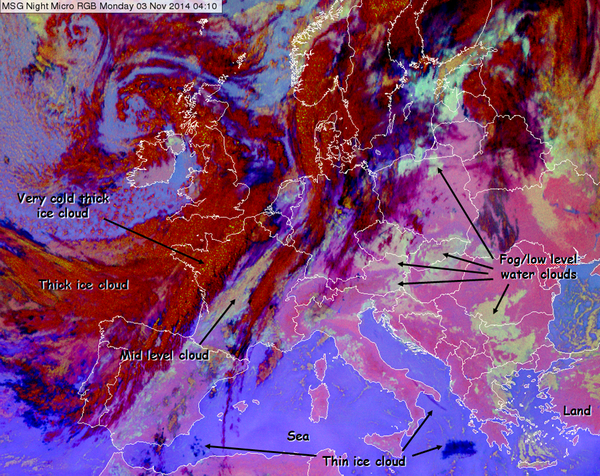
Two cases are shown with and without annotations to demonstrate the proper interpretation of different surface and cloud types in the Night Microphysics RGB images (Figs. 7 and 8).
In Fig. 7 frontal cloudiness is seen over the Atlantic Ocean and the western coast of Europe. In Central Europe we see a 'cold pool situation'. This is a typical late autumn or winter weather situation over the Carpathian Basin with long lasting fog or stratus clouds. The fog/low stratus forms in high pressure conditions. Cold air accumulates in the basin. Warmer air may advect above it, further increasing the vertical stability. There is no notable wind in the lower layers. These circumstances are favourable for the forming of long-lasting fog or stratus cloud. The temperature is low and the air is humid in the basin. The summits and ridges of the mountains are often above the layer of fog or stratus, and the weather is sunny and warm compared to the conditions in the basin.
| Figure 7: Night Microphysics RGB for 15 January 2006 at 01:55 UTC with and without annotations. |
|
In Fig. 8 we see a situation where a high pressure weather situation prevailed in southeast Europe. Previously, there had been a 10-day period without any frontal activity in the Carpathian Basin, which resulted in the so called 'cold pool' situation. There is frontal cloudiness over western and northern Europe, and an elongated frontal zone over the Finnish-Russian border and Belarus.
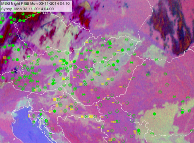
Fogs are forming due to nighttime radiation cooling (see the SYNOP observation in Fig 8b). The fog's formation and dissipation can be followed in the animation (3 November 2014, 00:10-13:10 UTC) created before sunrise from Night Micrphysics, and after sunrise from HRV Fog RGB images.The fog dissipates in several areas during daytime due to warming and air motion. In central Hungary relatively thin fog forms, and dissipates. South of the Carpathian Mountains and in the Czech Republic the fog is thicker. Thick low-level water clouds have a strong greenish colour; and the thinner the (radiation) fog, the more the colour resembles the pinkish colour of the ground. Very thin fog (e.g. only fog in the lowest 10 or 20 m) can be so similar to the ground that they can no longer be detected in the Night Microphysics RGB. This can be seen in Figure 8 and the corresponding loop, such as over Hungary. For example, there is thicker fog/stratus over northern Hungary and thinner fog over central Hungary in the 03:10 UTC image. As expected, the thinner fog dissolves more quickly, as one can see in the HRV Fog RGB loop of the following morning hours. So, the forecaster can use the colour of the fog to forecast possible dissolution. There are other areas (in Slovenia and Croatia) with thinner fog that dissolves more quickly.
Note that in the presence of a thermal inversion the mountains appear bluer than the lowland in the Night Microphysics RGB images. Stronger shades of blue signify higher temperatures.
| Figure 8: Night Microphysics RGB for 03 November 2014 at 04:10 UTC with and without annotation. |
|
| Figure 8b: Night Microphysics RGB for 03 November 2014 at 04:10 UTC overlaid by SYNOP observations |
|
| Animation 1: Time sequence of fog formation and dissipation (03 November 2014 00:10-13:10 UTC): Night microphysics RGB images (00:10-05:55 UTC) and HRV Fog RGB images (06:10-13:10 UTC) |
Benefits and limitations
The benefits of the Night Microphysics RGB
- At low and mid-latitudes the Night Microphysics RGB provides the best nighttime colour contrast between water clouds and the surface.
- Provides full cloud analysis at night.
- In some special conditions it provides nighttime snow detection - only if the temperature is very low and the snow is deep enough to cover completely the vegetation.
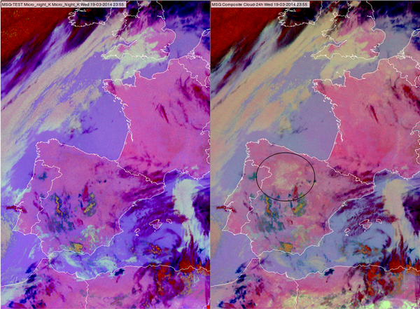
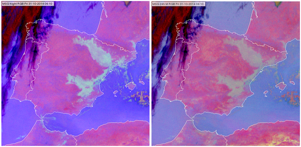
At low and mid-latitudes the Night Microphysics RGB provides the best nighttime colour contrast between water clouds and the surface. The 24 hour Microphysics RGB is also used for the same purpose. The big advantage of 24 hour Microphysics is that it is usable throughout the day, not just nighttime. However, the contrast between the surface and water clouds is less pronounced in the 24 hour Microphysics RGB images. Figs. 9a and b show comparisons between Night Microphysics and 24 hour Microphysics RGB images. Another limitation of the 24 hour Microphysics RGB is that the colour of bare soil (or desert) is close to the colour of the water clouds, see the encircled area in Fig 9a. Such bare soil area might be interpreted as low cloud in the 24 hour Microphysics RGB, but not in the Night Microphysics RGB. Note that at high latitudes the 24 hour Microphysics RGB is more useful.
| Figure 9a: Night Microphysics RGB (left) and 24 hour Microphysics RGB (right) for 19 March 2014 at 23:55 UTC |
|
| Figure 9b: Night Microphysics RGB (left) and 24 hour Microphysics RGB (right) for 31 October 2014 at 06:10 UTC |
|
The fog formation on the Iberian Peninsula shown in Fig. 9b can be follow in Animation 2.
| Animation 2: Time sequence of fog formation on the Iberian Peninsula created from Night Microphysics RGB images (30 October 2014 22:10 - 31 October 2014 07:10 UTC) |
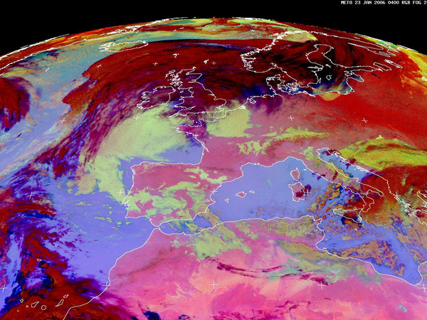
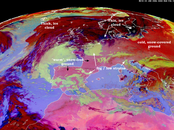
There is little to no information in IR images to help detect snow, unless it is very cold and vegetation is completely covered by a thick layer of snow. Fig. 10 shows an example for nighttime snow detection. The intense red colour in Eastern Europe indicates cold, snow-covered surfaces, while the pink colour in Western Europe indicates warmer, snow-free surfaces. This intense red colour is a combined effect of lower surface temperature (less blue) and lower (IR10.8-IR3.9) brightness temperature difference (less green) of the cold, snow-covered ground. The (IR10.8-IR3.9) brightness temperature difference depends on the emissivity of the ground at these two wavelengths. This night the minimum temperatures on these areas were below -20 °C.
| Figure 10: Snow detection at night on the Night Microphysics RGB, 23 January 2006 at 04:00 UTC. (Source: Jochen Kerkmann, Image Library, EUMETSAT, http://www.eumetsat.int/website/home/Images/ImageLibrary/DAT_IL_06_01_23.html) |
|
Limitations
- If there are thin, semitransparent cirrus clouds above water clouds, the Night Microphysics RGB might not detect the water clouds
- Extremely thin water cloud or fog might not be detected by the Night Microphysics RGB.
The IR3.9 channel is the key channel in the nighttime fog/low cloud detection. However, it causes also several problems in case the IR3.9 channel contains solar radiation
- The Night Microphysics RGB is not usable at daytime
- The solar radiation causes problems in low cloud detection at dawn /dusk as well.
- Around solar equinox the IR3.9 channel may contain some solar radiation around midnight, spoiling this RGB at some area.
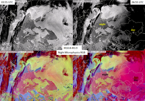
Fig. 11 shows the (IR10.8-IR3.9) difference image (up) and the Night Microphysics RGB image (bottom) at night (left panels) and at 06:55 UTC (right panels) when the sun is already up in the east, while in the western areas it is still night. There is a pronounced difference between the day and night parts of the images.
| Figure 11: The (IR10.8 - IR3.9) difference image (top) and the Night Microphysics RGB image (bottom) for 15 January 2006 at 03:55 UTC (left) and 06:55 UTC (right) |
|
At dawn and dusk (twilight) the fog or water clouds 'disappear' from the Night Microphysics RGB. This happens because the (IR10.8-IR3.9) difference is positive at night and negative in the day, while at a low solar elevation angle it is around zero, like for a cloud-free surface (see Figs. 12 a, b and c).
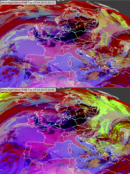
Around solar equinox the IR3.9 channel may contain some solar radiation (stray light) around midnight, spoiling the Night Microphysics RGB in some areas. The bottom panel of Fig. 13 shows such a situation. The upper panel shows the area half an hour earlier, without stray light. The stray light effect appears only on few images (see Animation 3).
| Figure 13: Night Microphysics RGB images for 7 April 2015 at 23:10 and 23:40 UTC. The bottom panel shows the stray light effect. |
|
| Animation 3: 30-minute Night Microphysics RGB images (27 August 2006 at 22:00 UTC - 28 August 2006 at 02:00 UTC) some with stray light. (Source: Jochen Kerkmann, MSG Interpretation Guide, EUMETSAT) |
Due to the limitations of Night Microphysics, such as the problem caused by the presence of the solar radiation, the 24 hour Microphysics RGB is officially recommended for operational fog/low stratus detection. It is usable the whole day, and works well also over Scandinavia. However, the parallel use of Night Microphysics RGB images might be beneficial because of the better colour contrast.
Exercise
Exercise
Question
Match the following cloud and land features to the numbers!
Thick ice clouds, Tin ice clouds / cirrus, Mid level cloud, Low level water clouds or fog, Sea, Land
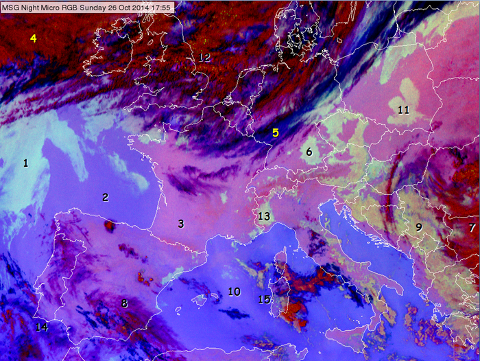
| 1 | 2 | 3 | 4 | 5 | 6 | 7 | 8 | 9 | 10 | 11 | 12 | 13 | 14 | 15 | |
|---|---|---|---|---|---|---|---|---|---|---|---|---|---|---|---|
| Thick ice clouds | X | X | X | ||||||||||||
| Thin ice clouds / cirrus | X | X | X | ||||||||||||
| Mid level clouds | X | ||||||||||||||
| Low level water clouds or fog | X | X | X | X | |||||||||||
| Land | X | ||||||||||||||
| Sea | X | X | X |
Question
Take a look at the above figure again and answer the following question:
Where is the atmosphere moisture content higher, at location 10 or 15?
Moisture content is higher at location 15.
