Chapter II: HRV Fog RGB
Table of Contents
The aim of this type of RGB is to distinguish the cloud-free snow covered land from fog or low level water clouds in a high resolution image. Wintertime fog frequently forms over snowy cloud-free surfaces in high pressure conditions. It is important to identify foggy areas, for example for purposes of traffic security.
The HRV fog RGB is created by combining data from two different channels. The 1.6 micrometer channel (NIR1.6) data is visualised in red, and the High Resolution Visible (HRV) image in green and blue. The NIR1.6 channel helps to discriminate snow-covered land from fog or low water clouds and water clouds from ice clouds. Its combination with HRV provides high resolution information on cloud structure and thickness. Note that one has to use HRV in two colours not too lose the high resolution, so only two different channels can be used in this type of RGB. This is a daytime RGB as it uses shortwave channels. Its main application period is in winter.
Physical basis
Separation between snow and fog or water clouds
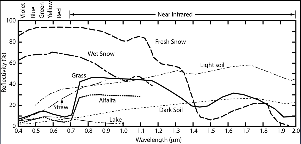
The key channel of daytime snow detection is NIR1.6. Fig. 1 presents the typical shortwave reflectivity spectra of some surface types including snow. Considering that the spectral bandwidth of HRV is from 0.4 to 1.1 micrometers, while that of NIR1.6 is from 1.5 to 1.78 micrometers, one can see that the snow's reflectivity is much higher in HRV than in NIR1.6. Snow is bright in HRV and dark in the NIR1.6 image. Because water clouds reflect much of the radiation in both channels (not shown in Fig. 1), they can be used in combination to distinguish snow and water clouds.
| Figure 1: Typical shortwave reflectivity spectra of surface types. (Courtesy of Steve Ackerman, CIMSS) |
|
Separation between ice and water clouds
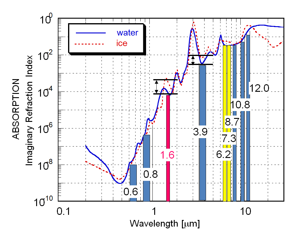
Ice crystals absorb radiation more strongly than water particles in the NIR1.6 channel (Fig. 2).
| Figure 2: Absorption spectra of water (blue curve) and ice (dashed red curve) and the spectral bandwidth of the SEVIRI channels (Courtesy of Daniel Rosenfeld, HUJ) |
|
Fig. 2 presents the imaginary refraction index of water and ice. This index characterises the absorption of the material, not the absorption of a cloud layer. A cloud layer's absorption depends on many other things as well (like number of the droplets/particles etc), but the absorption coefficient of the material has a dominant role. Due to the higher absorption of ice in the NIR1.6 channel the reflection of the ice clouds is lower than that of the water clouds. (Note that the difference between ice and water absorption is not small: it is visualised in a logarithmic scale.)
Creating HRV Fog RGB images
The 'recipe' of the HRV Fog RGB type is summarized in the following table. Table 1 shows which channels are visualized in which colour. The measured values should be calibrated to calculate reflectivity, including solar zenith angle correction. The images should be then enhanced - linearly stretched - within the reflectivity ranges shown in the table.
Table 1: Recipe of the HRV Fog RGB
| Colour beam | Channel | Range [%] | |
|---|---|---|---|
| Red | NIR1.6 | 0 | 70 |
| Green | HRV | 0 | 100 |
| Blue | HRV | 0 | 100 |
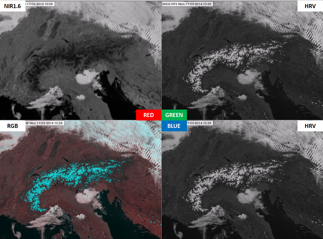
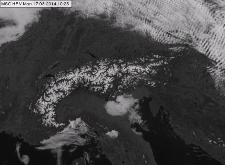
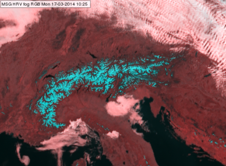
The following example shows how the HRV Fog RGB is combined from the NIR1.6 and HRV images. It shows not only the resulting RGB image, but the components as well. First we show an example of a cloud-free area with water clouds, and then an example with ice clouds.
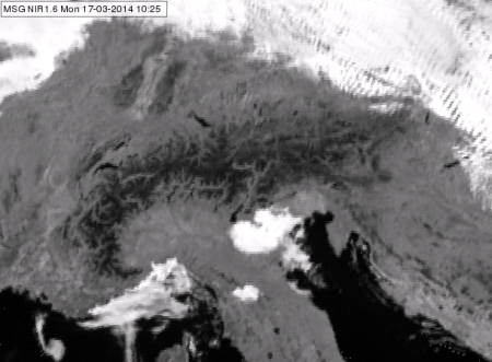
Fig. 3a shows the NIR1.6 (top left) and the HRV (top and bottom right) channels stretched in the 0-100 % reflectivity range. The RGB (bottom left) was created from these images with NIR1.6 as the red component and HRV as the blue and green components. Fig. 3b shows the same channels, but now NIR1.6 is stretched between 0-70 %, and the RGB is created from this more enhanced NIR1.6 channel. This is the so called HRV Fog RGB image. The range (of red colour) is smaller for the NIR1.6 than for the HRV channel (green and blue colours), causing a stronger enhancement of NIR1.6. It was tuned in this way to get better colour contrast between water clouds and snow-covered land. Comparing the RGB images in Figs. 3a and 3b we see that the stronger enhancement of NIR1.6 results in pinkish water clouds instead of whitish ones; more red than green and blue, with the latter two in equal measure. Snow appears cyan as it contains equal quantities of green and blue and much less red. The pinkish water clouds (Fig. 3b) have better colour contrast with the cyan snow than whitish water clouds (Fig. 3a) would have.
| Figure 3a: SEVIRI single channels and RGB for 17 March 2014 at 10:25 UTC. The NIR1.6 (top left) and the HRV (top and bottom right) are stretched in 0-100 % reflectivity range. The RGB (bottom left) was created from these images with NIR1.6 as the red component and HRV as the blue and green components. |
|
| Figure 3b: Same as Fig. 3a, but NIR1.6 is stretched between 0-70 %, and the RGB is created from this more enhanced NIR1.6 |

|
In Figs. 4a and 4b the HRV Fog RGB image can be compared with NIR1.6 and HRV images. One can see that the high resolution is coming from the HRV image, while the snow detection is enabled by the difference between the NIR1.6 and HRV channel data.
| Figure 4a: SEVIRI NIR1.6 channel (stretched in 0-70 % reflectivity range) and HRV Fog RGB for 17 March 2014 10:25 UTC. |
|
| Figure 4b: SEVIRI HRV broadband channel (stretched in 0-100 % reflectivity range) and HRV Fog RGB for 17 March 2014 10:25 UTC. |
|
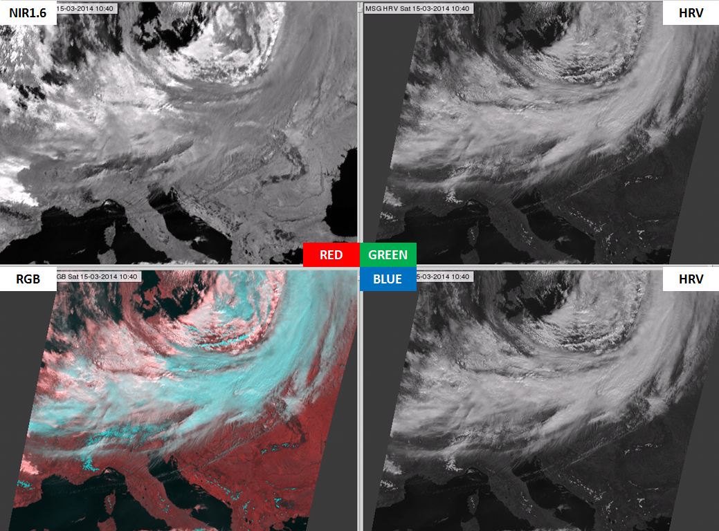
The appearance of ice and water clouds will be compared in the second example. Fig. 5 shows a cold front. Ice clouds are darker than water clouds in the NIR1.6 image (upper left panel of Fig. 5), while their reflectivity values are similar in HRV image (right panels of Fig 10.5). As a consequence, ice clouds are cyan in the HRV Fog RGB image (similar to snowy land, but with slight greyish tones), while water clouds are pinkish. There is a definite colour contrast between ice and water clouds.
| Figure 5: NIR1.6 (upper left), HRV (upper and bottom right) and HRV Fog RGB image (bottom left) for 15 March 2014 10:40 UTC. NIR1.6 is linearly stretched in the 0-70 %, while HRV is enhanced in the 0-100 % reflectivity intervals. |
|
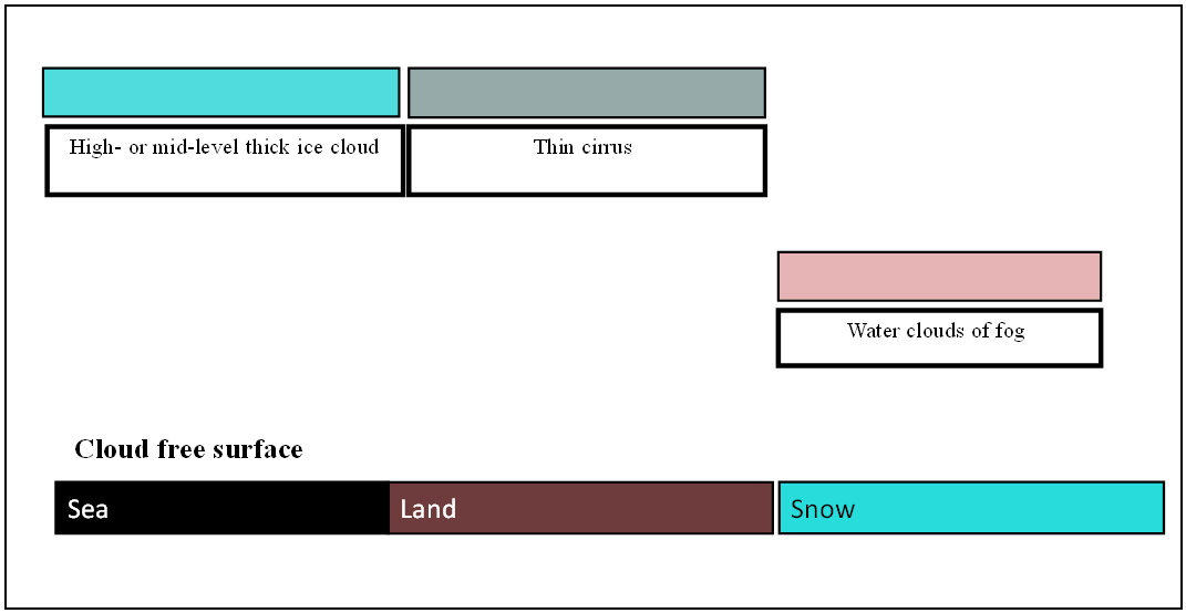
Typical colours
Fig. 6 shows the typical colours of the HRV Fog RGB images. The colours of the semitransparent clouds depend on many factors, for example on their thickness and on the colour of the underlying surface.
| Figure 6: Typical colours of the HRV Fog RGB (Source: Jochen Kerkmann, MSG Interpretation Guide, EUMETSAT) |
|
There is a good colour contrast between snow and land and between snow and water clouds. Unfortunately snow and thick ice clouds have similar colours. However, the movement and the structure may help to discriminate them.
Examples of interpretation
Two cases are shown with and without annotations to give examples on the proper interpretation of the different surface and cloud types (Figs. 7 and 8), and to draw attention to the typical features of snow.
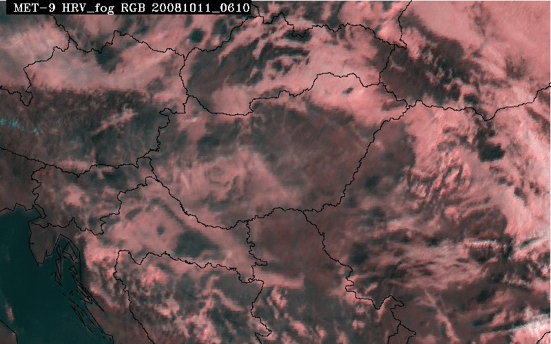
| Figure 7: HRV Fog RGB for 11 January 2008 at 08:55 UTC with and without interpretation |
 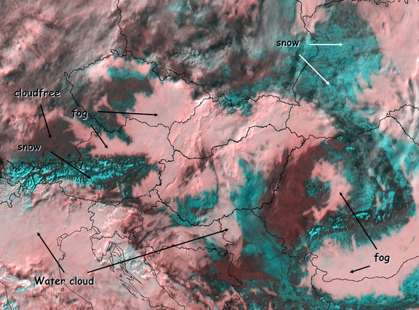
|
| Figure 8: HRV Fog RGB for 08 January 2009 at 09:20 UTC with and without interpretation |
 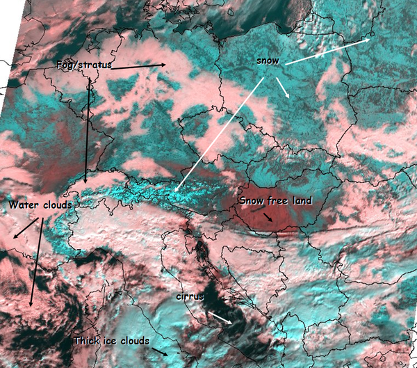
|
Cloud-free snowy land can have a variable appearance in satellite imagery. If the snow lies on a plain or low hill, one can often see patches, spots or lines in it. Patches might be wooded areas, with shadows and branches not covered by snow. Lines might be rivers and spots (small patches) could be settlements. With snow-covered mountains one can often see the structure of the valleys and ridges. Snow on high mountains usually has a brighter colour than on hills or lowlands, as the snow cover is less disrupted by vegetation.
Benefits and limitations
Benefits
- Good discrimination between snow and water clouds
- High spatial resolution
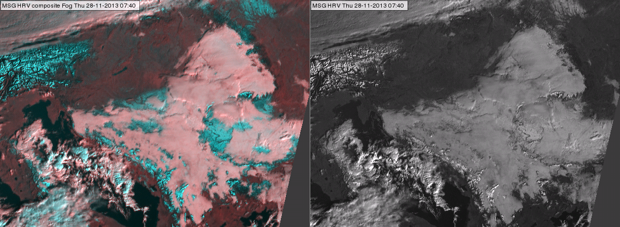
Fig. 9 shows the benefit of HRV Fog RGB compared to the HRV image. It is much easier to distinguish snow and water cloud in the HRV Fog RGB image, because of the excellent colour contrast.
| Figure 9: HRV Fog RGB (left) and HRV (right) image for 28 November 2013 at 07:40 UTC |
|
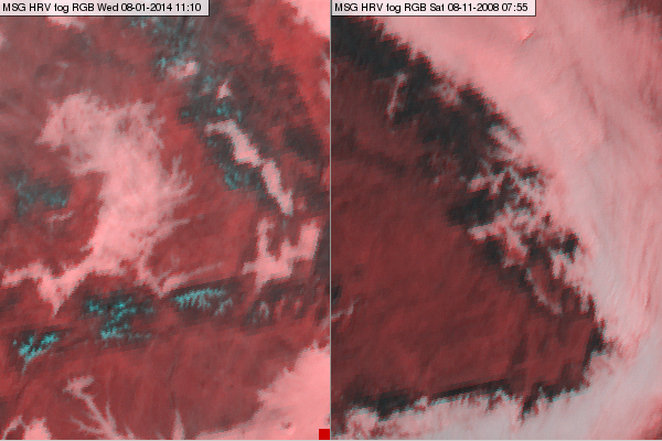
Due to the high resolution, this RGB is more useful for monitoring smaller features like valley fogs than the 3 km resolution single channels or the RGBs composed from 3 km resolution images. Examples of these are shown in Fig. 10.
| Figure 10: Valley fog in HRV Fog RGB images for 08 January 2014 at 11:10 UTC (left) and 8 November 2008 at 07:55 UTC (right) |
|
Combined high spatial and temporal resolution can be beneficial for forecasting fog dissipation. 5-minute data is particularly useful for monitoring rapid fog dissipation. Fig. 11a shows a MODIS true colour image on Lake Balaton covered with fog. Fig. 11b shows the fog dissipation from 06:10 to 10:55 UTC (animation created from 5-minute SEVIRI HRV Fog RGB images).
| Figure 11a: MODIS true colour image for 11 October 2008 at 09:50 UTC |
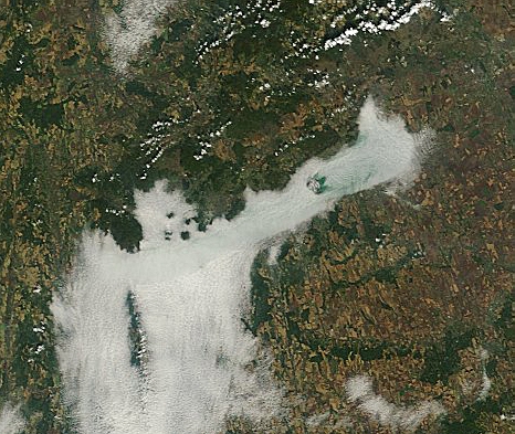
|
| Figure 11b: METEOSAT HRV Fog RGB animation (11 October 2008, 06:10-10:55 UTC) |
|
Limitations
- Only works in daytime.
- Ice clouds and snow have similar colours.
- Thin cirrus clouds are undetected, or barely so.
Fig. 12 demonstrates how thin cirrus clouds are difficult to detect in this type of RGB image. Here we can compare a HRV Fog RGB image with the corresponding Dust RGB image. The Dust RGB shows thin cirrus (indicated by black circle in the right panel), which is not seen in the HRV Fog RGB image (left panel). Thin cirrus clouds are usually much less visible in shortwave images than in infrared ones, while the Dust RGB is very sensitive to thin cirrus clouds.
| Figure 12: HRV Fog RGB (left) and Dust RGB (right) for 17 March 2014 at 10:25 UTC. The encircled area is covered by thin cirrus clouds. |
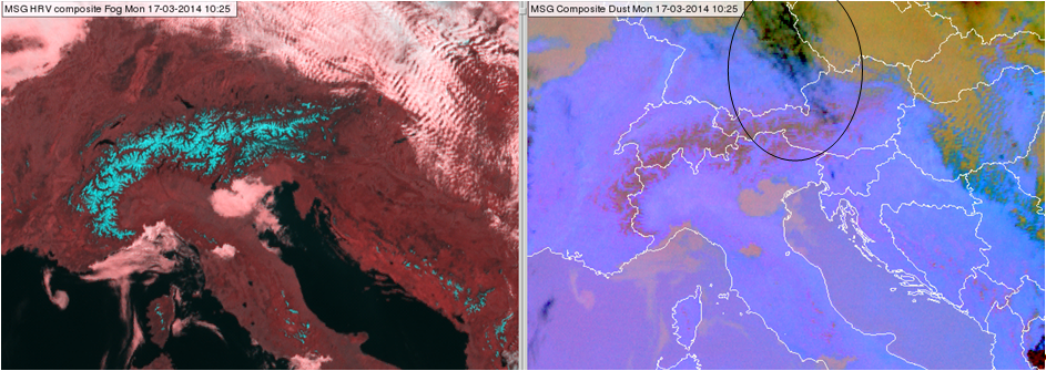
|
Comparisons with other RGB images
HRV Fog and Natural Colour RGBs
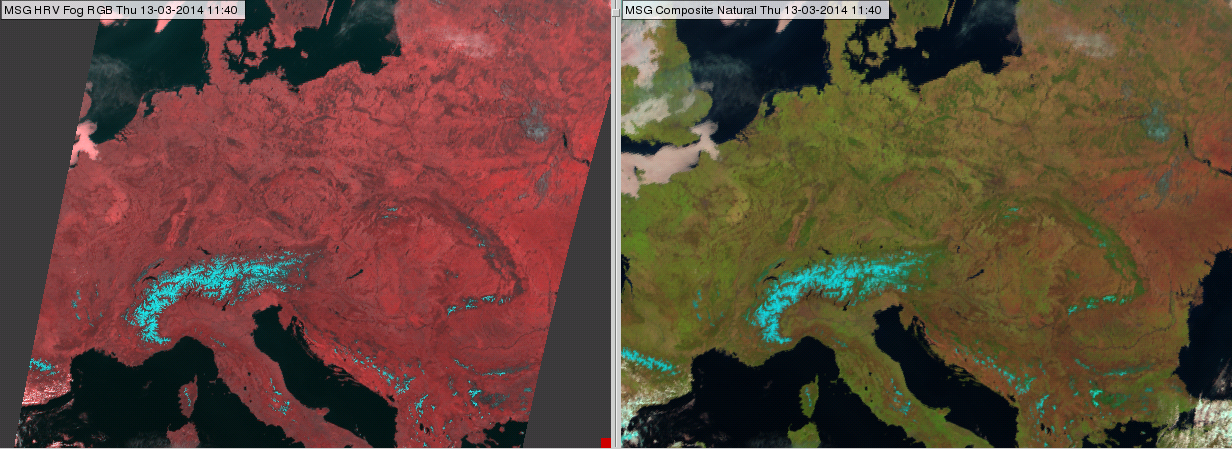
The HRV Fog RGB and the Natural Colours RGB images are composed from 'similar' channels. Both RGB types present the NIR1.6 channel in red, and visible channels are presented in green and blue. That is why the snow and the clouds will have similar colours (Fig. 13). However, the appearance of the snow-free land is very different. The Natural Colour RGB uses different channels in the blue and green components. The 0.8 and 0.6 micrometer channels (VIS0.8 and VIS0.6) together provide vegetation information which is totally missing from the HRV Fog RGB image. The reason is demonstrated in Fig. 14; the reflectivity of green vegetation differs considerably in the VIS0.8 and VIS0.6 channels. More green in the Natural Colours RGB means that the pixel is covered by vegetation containing more chlorophyll.
| Figure 13: HRV Fog RGB (left) and Natural Colour RGB (right) for 13 February 2014 at 11:40 UTC |
|
| Figure 14: Typical reflectivity functions of green leaf and bare soil (green and brown curves) in the shortwave spectral region plotted with the top of the atmosphere irradiance (red curve) and the response functions of the shortwave SEVIRI channels (gray curves) (Source: MSG Interpretation Guide, EUMETSAT) |

|
Suggestions:
- For information on vegetation, one has to use the Natural Colour RGB.
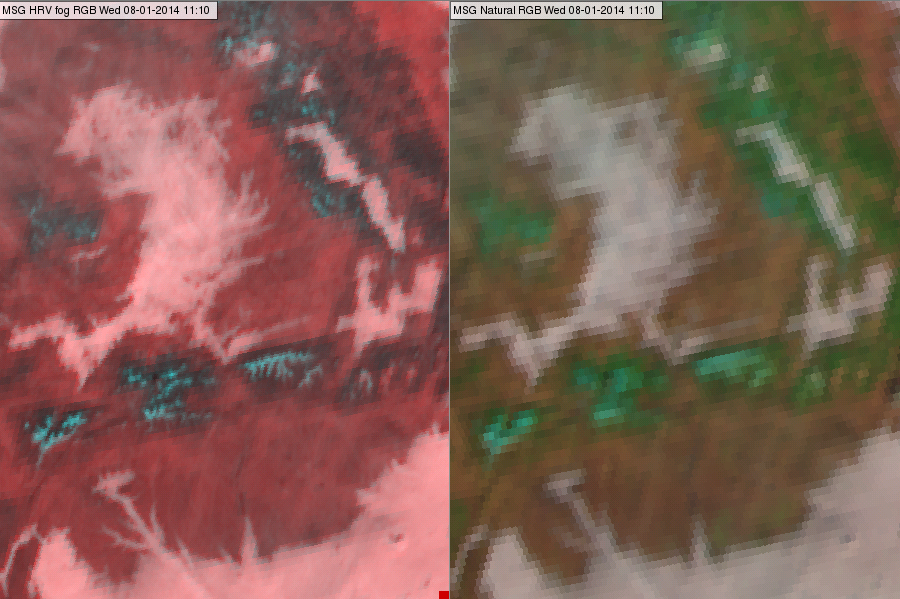
- If we are interested in small scale details like valley fog, the HRV Fog RGB provides more details (Fig. 15).
| Figure 15: Valley fog in HRV Fog RGB (left) and Natural Colours RGB (right) for 8 January 2014 at 11:10 UTC. |
|
HRV Fog and HRV Cloud RGBs
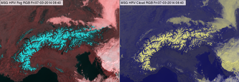
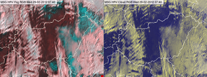
Both RGB types use HRV in two colour beams. The HRV Fog RGB combines the HRV information (high resolution cloud structure and cloud thickness) with NIR1.6 channel information (cloud phase and snow on the surface). The HRV Cloud RGB combines the HRV information with IR10.8 channel information (cloud top temperature). HRV Fog RGB is mainly useful in winter while the HRV Cloud RGB is mainly applicable during summer, as its main application is monitoring convection.
Figs. 16 and 17 compare HRV Fog and HRV Cloud RGB images. One can see that in HRV Cloud RGB there is no colour contrast between snow and water clouds. In winter, HRV Fog RGBs are more useful than HRV Cloud RGB images.
| Figure 16: HRV Fog RGB (left) and HRV Cloud RGB (right) for 07 March 2014 at 08:40 UTC |
|
| Figure 17: HRV Fog RGB (left) and HRV Cloud RGB (right) for 29 February 2012 at 07:40 UTC |
|
Exercises
Exercise 1
Question
Which of the following features are present in the numbered areas?
Water cloud, Cirrus, Snow on mountains, Snow free land, Sea
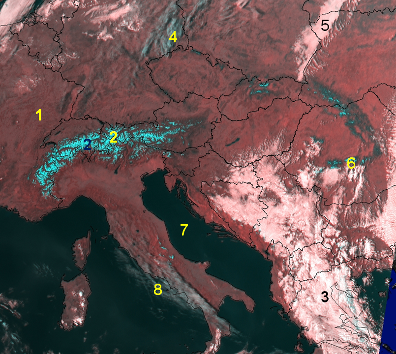
| 1 | 2 | 3 | 4 | 5 | 6 | 7 | 8 | |
|---|---|---|---|---|---|---|---|---|
| Water cloud | X | X | ||||||
| Cirrus | X | X | ||||||
| Snow on mountains | X | X | ||||||
| Snow free land | X | |||||||
| Sea | X |
Exercise 2
Question
Several different features appear (greyish) cyan in the HRV Fog RGB. The structure helps to discriminate them. Which of the following features are present in the numbered areas?
Semitransparent ice clouds/ cirrus, Semitransparent ice cloud/ cirrus over snow, Thick ice clouds, Snow on ground
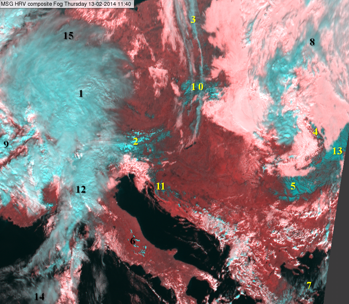
| 1 | 2 | 3 | 4 | 5 | 6 | 7 | 8 | 9 | 10 | 11 | 12 | 13 | 14 | 15 | |
|---|---|---|---|---|---|---|---|---|---|---|---|---|---|---|---|
| Semitransparent ice clouds/ cirrus | X | X | X | X | X | X | |||||||||
| Semitransparent ice cloud/ cirrus over snow | X | ||||||||||||||
| Thick ice clouds | X | X | X | ||||||||||||
| Snow on ground | X | X | X | X | X | X |