Chapter IV: Other observations
Table of Contents
Soundings
Radio soundings are the best observations for revealing the possibility of icing. A sounding shows wind, temperature T and dew point Td as functions of height. The existence of clouds can be seen from the difference of T and Td (dew point depression).
At temperatures above 0 °C, if T = Td, the relative humidity is 100 %, and the air is saturated with respect to water vapor. In the saturated stage there is liquid water, and an equal number of water molecules are evaporating from the water and condensing into it.
Below the freezing point there is ice in the saturated stage. The bonding between neighboring molecules is stronger in solid than in liquid phase. It is harder for the water molecules to evaporate from ice than from water, so it requires more energy, that is, higher temperature. The air is saturated when the temperature reaches frost point Tf.
The frost point is between air temperature and the dew point. Therefore, in cold air the air can be saturated and clouds formed even though the temperature has not reached the dew point. In practice the supercooled clouds can be detected from soundings between -1°C … -15°C as having T≈ Td, while for ice clouds there is a difference of one or two grades.
In the following example there's supercooled water between 980 and 810 hPa, and ice clouds between 420 and 280 hPa:
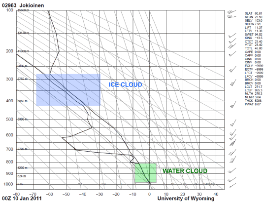
Fig. 4.1. Ice and supercooled water clouds in a sounding.
Note that a sounding is a point measurement, steered by the upper winds. Therefore, the sounding may not always fully represent the clouds above the sounding station, and the sounding may miss the most freezing conditions.
Radar
Weather radars detect particles which reflect microwaves, for example water drops, ice crystals, insects and birds. They give a more detailed picture of the 3-dimensional structure of precipitating clouds than satellite images, albeit from very limited areas.
When using radar images, it must be taken into account that radar does not detect cloud droplets, but only larger rain drops.
The intensity of the radar echo depends strongly on the size of the particle (it is proportional to the 6th power of diameter), so that one 2 mm drop registers as strongly as 64 individual 1 mm drops together.
The sensitivity of a radar weakens with distance. Remote echoes (in water clouds at distances greater than 20 km) must be intensive to be seen, while weaker echoes nearer the radar are also detected. In stratiform clouds the cloud drops are mostly too small to be seen. Hence, only icing conditions caused by large supercooled drops can be seen by radar.
Another feature of radars that must be remembered is that when a beam is sent, the Earth's surface curves down from it. As the beam recedes away from the radar, this difference in height increases. This is shown schematically in the following image:
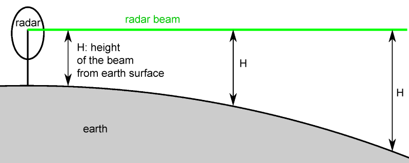
Fig 4.2. Curving of the Earth's surface below the radar beam
In real atmosphere the radar beam curves towards Earth surface because of the thinning of the air upwards:
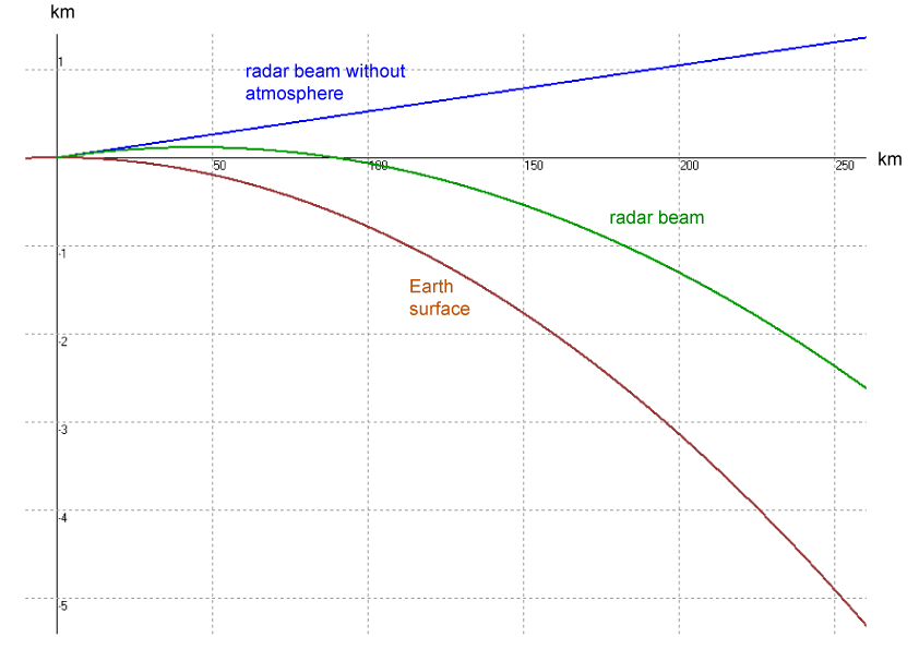
Fig. 4.3. Radar beam's distance from the Earth's surface as a function of distance from radar/km
CAPPI images are made from the lowest elevation angle, 0,3°. At 100 km distance, the lowest beam is 1200 m, and at 150 km , it is 2500 m. So, there might be low clouds around the radar, but they are seen only near the antenna.
The intensity of the echo depends on the target that the beam hits:
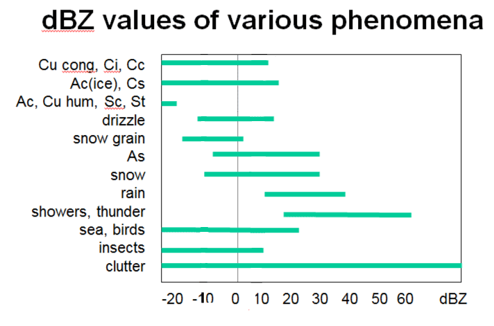
Fig.4.4. dBZ values for various phenomena.
There are two kinds of weather radars: conventional and dual-polarization radars.
A conventional radar measures the horizontal component of the backscattered echo power, and the result is given as 10 log (Zh), called reflectivity dBZ.
Differentiating between the ice and water phases is based on the fact that ice particles give a weaker echo than water drops. So, icing is possible in a stratiform cloud if there is an area of more intensive echo than in the surroundings.
Of course, intensive echoes can also refer to other features, such as embedded cumulonimbus or a melting layer (bright band), so 3D radar products are preferable whenever available, to rule out false alarms. However, if that is not possible, embedded cumulonimbus can usually be detected from satellite images, and a melting layer from soundings.
In the image below there are 25-30 dBz echoes near the right edge, while elsewhere the echoes are less intense. Halli Airport, located just south of the intensive area, reported icing in this event.
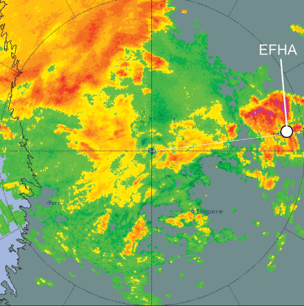
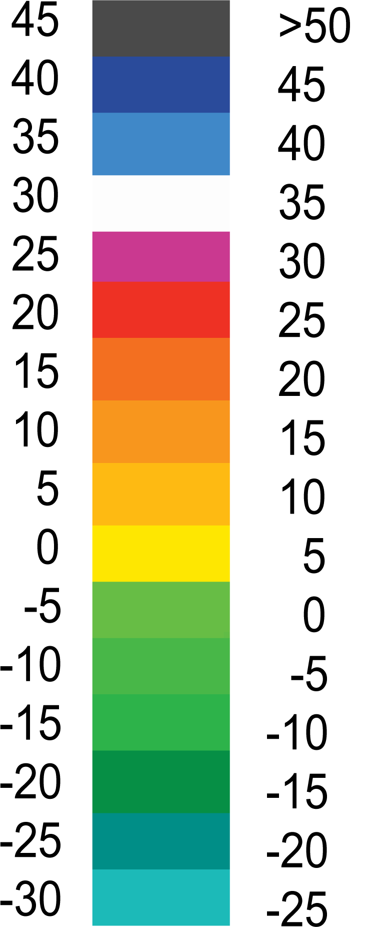
Fig 4.5. Cappi image from Ikaalinen radar, with image colours as a function of radar echoes/dBz .
Dual-polarization radars provide a number of additional products to dBZ. Among them are differential reflectivity and co-polar correlation coefficient:
Differential reflectivity, usually indicated as ZDR, is the ratio between horizontal (ZH) and vertical (ZV) reflectivity. ZDR is expressed in logarithmic unit (dB): it is zero if ZH and ZV are the same, positive if ZH is larger than ZV, and negative if ZH is smaller than ZV.
Co-polar correlation coefficient (ρHV, rhoHV)
Co-polar correlation coefficient is the correlation between the signal at horizontal
and vertical polarization. The correlation is high when the radar measurement
volume is filled with homogenous population of targets such as raindrops or
snowflakes only, and low when there is a mixture of different particles such as
raindrops together with hail or snow.
Combination of dBZ, ZDR and ρHV gives a rather good estimate of hydrometeor class: is it hail, wet snow or rain. In EDGE and IRIS radar display software, the product is called hydroclass, in Rainbow software Eclass (echo classification).
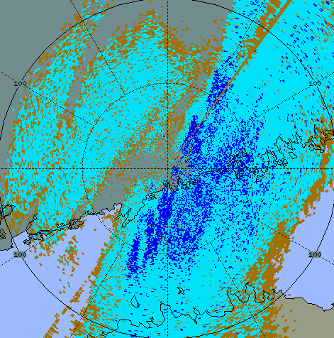
Fig 4.6. HCLASS_PPI product from Vantaa, with color scale
In this image the "wet snow" class might be supercooled water, where the temperature is below zero.