Chapter III: Satellite products
Table of Contents
Satellite images are used differently in the middle and high latitudes when it comes to icing. Three factors are of concern: space resolution, time resolution, and the availability of daylight.
The space resolution of MSG is fairly good in the middle latitudes, and there's daylight throughout the year. On the other hand, AVHRR images come only a couple of times a day, and thus are of limited importance.
In high latitudes the space resolution of Seviri images is poorer, and they do not reach the northernmost areas at all. AVHRR images are available around 14 times a day, plentiful enough to be useful. Daylight is sparse in winter, so the images used are usually the infrared ones.
Note: satellite images show the highest clouds, and if they are thick, these clouds can obscure lower clouds.
Differentiating between ice and water clouds
NIR 1.6
The best tool for this is the near infrared (NIR) channel with the wavelength 1,6 μm. This channel is available in Seviri images from the geostationary satellite MSG. It distinguishes both water phases and cloud droplet/particle sizes:
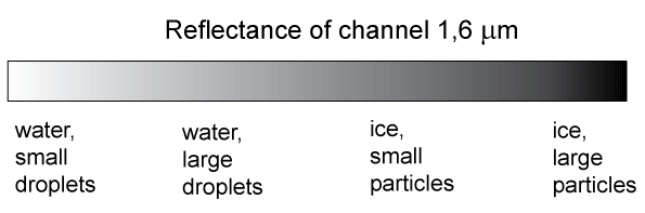
Fig 3.1. Reflectance of clouds in channel 1.6μm.
In NIR1.6 image water clouds are white:
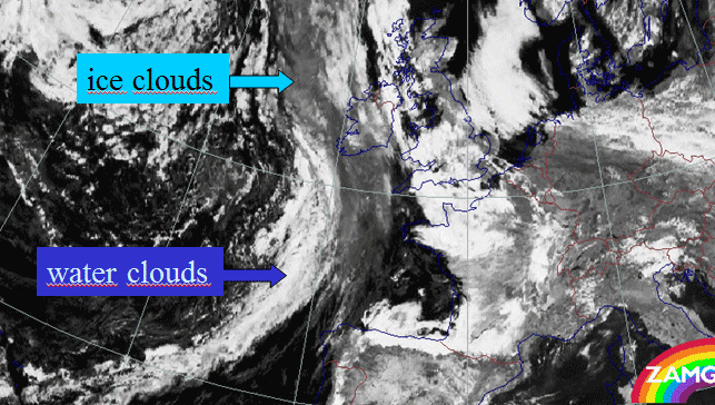
Fig. 3.2. Ice and water clouds in channel 1,6μm.
This channel, being a solar channel, can only be used during daytime.
NIR 3.9
Another channel that can used similarly to 1,6 μm is the 3,9 μm channel, which is partly solar and partly infrared. This channel is available both in MSG and polar orbiting satellites. In the channel there is a difference in wavelength in the reflection of solar radiation from ice particles and water drops. Properties of the channel:
- Reflection at 3,9 μm is sensitive to cloud phase and very sensitive to particle size.
- Reflection is stronger from water droplets than from ice particles.
- During daytime, clouds with small water droplets (stratus and stratocumulus) are much darker than ice clouds.
- Stratocumulus is darker over sea than land.
Figure 3.3. shows particle radius/µm as a function of single scattering albedo. This albedo is the ratio of scattering efficiency to total extinction efficiency (attenuation). The attenuation for water is clearly different from the attenuation for ice.
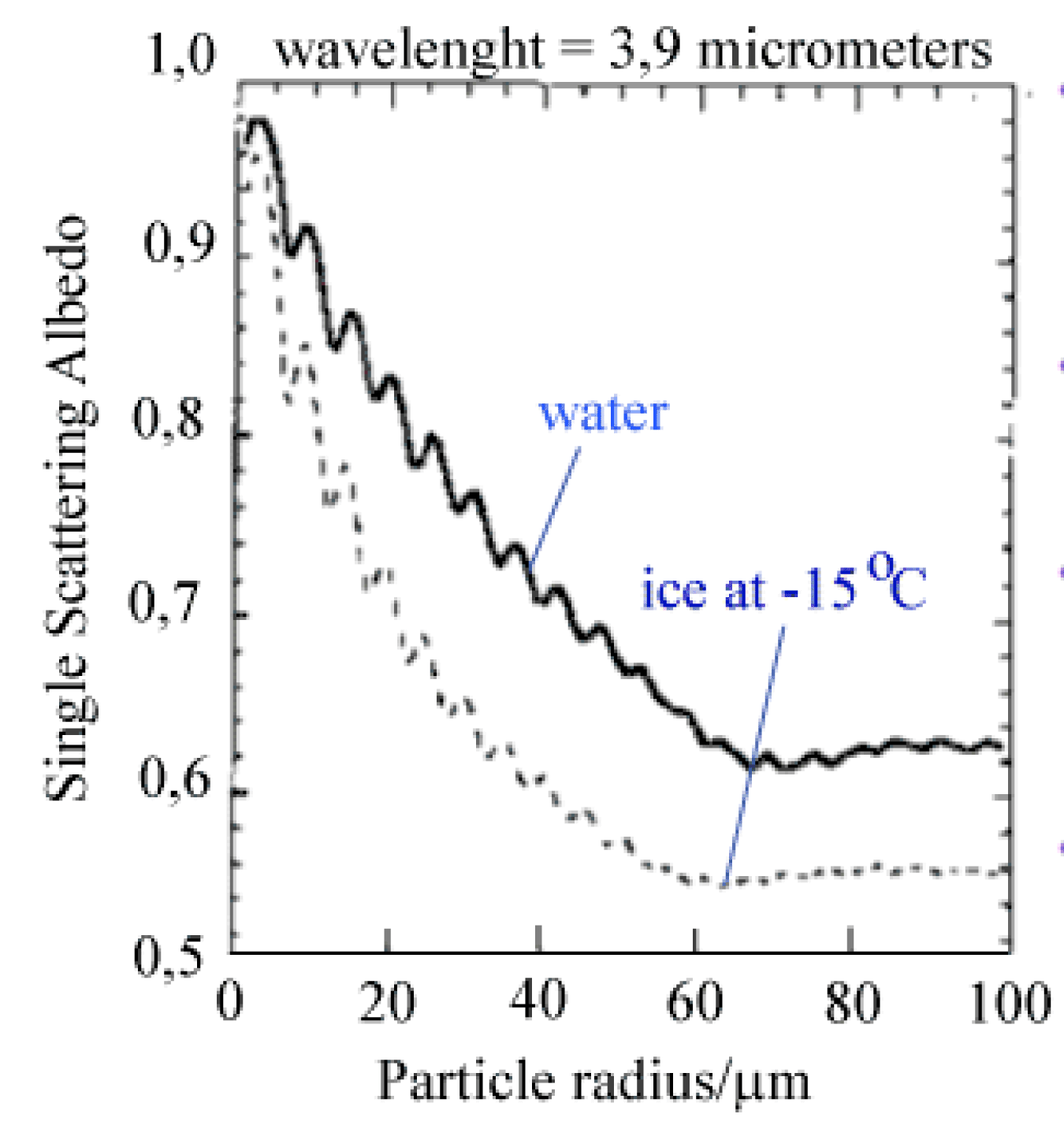
Figure 3.3. Attenuation for ice and water as a function of particle radius/µm.
Differences between infrared channels 10,8 µm and 12,0 µm
A product that can be used day and night is the difference between two infrared channels: 10.8 µm – 12.0 µm. In the 10,8 µm channel the absorption levels are the same for both water and ice, but 12,0 µm is absorbed slightly more strongly in the ice phase. The difference is too small to be actually seen by comparing the images, but it can be revealed clearly when the two channels are subtracted.
In general, when studying the propagation of electromagnetic waves through any material, it is presented as refractive index (a plain number, varying greatly with wavelength). In opaque material this index is a complex number, where the real component describes refraction and the imaginary part accounts for absorption.
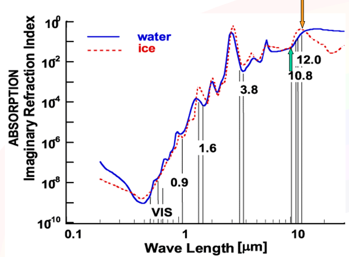
Fig. 3.4. Imaginary refractive index for water and ice as a function of wave length/µm. The green and orange arrows show the absorption for the wavelenghts 10,8 µm and 12,0 µm.
Differences between solar channels 0,6 µm and 0,9 µm
The solar 0,6 μm channel reflects more strongly from optically dense objects than from transparent ones - that means that snow and ice clouds appear lighter than water clouds. On the other hand, 0,9 μm (which is referred to as a visual channel, in spite of it being slightly outside the human visual range) is reflected more strongly from ground than from low (usually water) clouds. The albedo for different reflective objects as a function of wavelength:
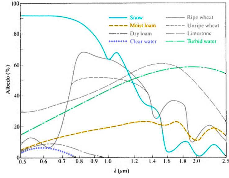
Fig. 3.5. Albedo as a function of some reflective objects. (EUMETSAT)
Seviri images
Seviri images are mostly used as RGB (red-green-blue) composites. In this method three channels or channel differences are combined to reveal information that cannot be seen in single channels. For more information about RGB, see Eumetsat's RGB Guide:
http://oiswww.eumetsat.org/WEBOPS/msg_interpretation/index.php
The most useful day and night Seviri product for detecting possible icing clouds is Microphysical. During daytime the most useful product is HRVFog.
Microphysical (infrared channels)
- Difference IR12.0 - IR10.8 (phase and optical thickness)
- Difference IR10.8 - IR8.7 (phase and optical thickness)
- Channel IR10.8 (top temperature)
Interpretation of the images:
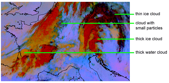
Fig. 3.6. Microphysical combination
Water clouds without ice clouds above them can be seen as yellow-orange; the deeper the color, the thicker the cloud. When combined with temperature data, the image can reveal a potential icing cloud.
HRVFog (solar)
In this product the key channel for detecting icing is NIR1.6. In addition, the HRV (High Resolution Visible) channel brings a better resolution to the image. The name of the combination comes from the fact that it is used for detecting fog/low stratus and snow. The darker the pinkish water cloud is, the lower it is. High water clouds appear light pinkish.
- Channel NIR1.6 (phase)
- Channel HRV 0,5…0,9µm
- Channel HRV 0,5…0,9 µm
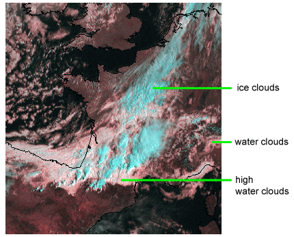
Fig 3.7. HRVFog combination
Artificially colored images
In many NMS's the Seviri images are converted into artificially colored images to emphasize certain features. These procedures combine data from several satellite channels, nwp output and observations. An example of this kind of interpretation product is Meteo France's Ice Cloud Product ICLD, where the potential icing clouds are shown red:
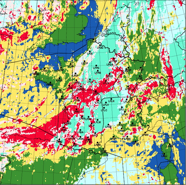
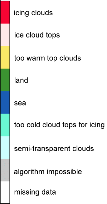
Fig. 3.8. ICLD product from Meteo France, with color scale
AVHRR images
The polar orbiting satellites have AVHRR instruments, with channels that differentiate from those of Seviri. Differentiating between water and ice clouds is more difficult with AVHRR channels than with those of Seviri. Having a better resolution than Seviri images, they complete the information received from MSG. This is true especially at high latitudes, where the images also come more often than middle latitudes, so as to be actually useful in nowcasting and short-range forecasting.
In middle latitudes, the Seviri images have a relatively high resolution, and visible channels can be used throughout the winter in daytime, so there the importance of AVHRR images is lower - as is their availability.
The most important AVHRR product that is available day and night and can tell the difference between water and ice clouds is "comb 345". In daytime this combination is (1.6 μm + 10.9 μm + 12,0 μm), and in nighttime (3,7 μm + 10.9 μm + 12,0 μm).
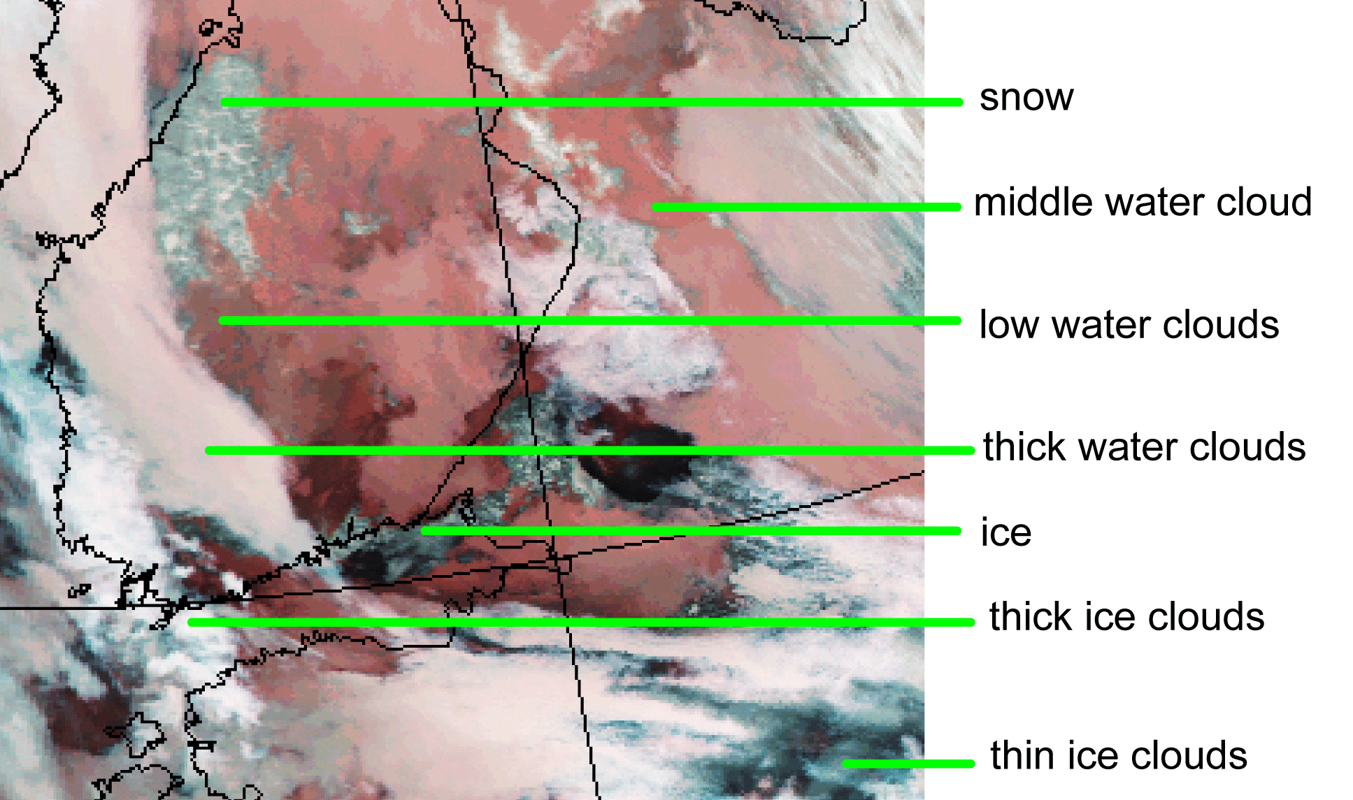
Fig. 3.9. AVHRR combination image 345
During daytime a combination of visual and infrared channels can also be used: "comb124" (0,6 μm + 0.9 μm + 10.9μm). In practice, as most icing cases occur in winter, this image is seldom of use. It can, however, reveal quite nicely different clouds in autumn and spring (October, March).
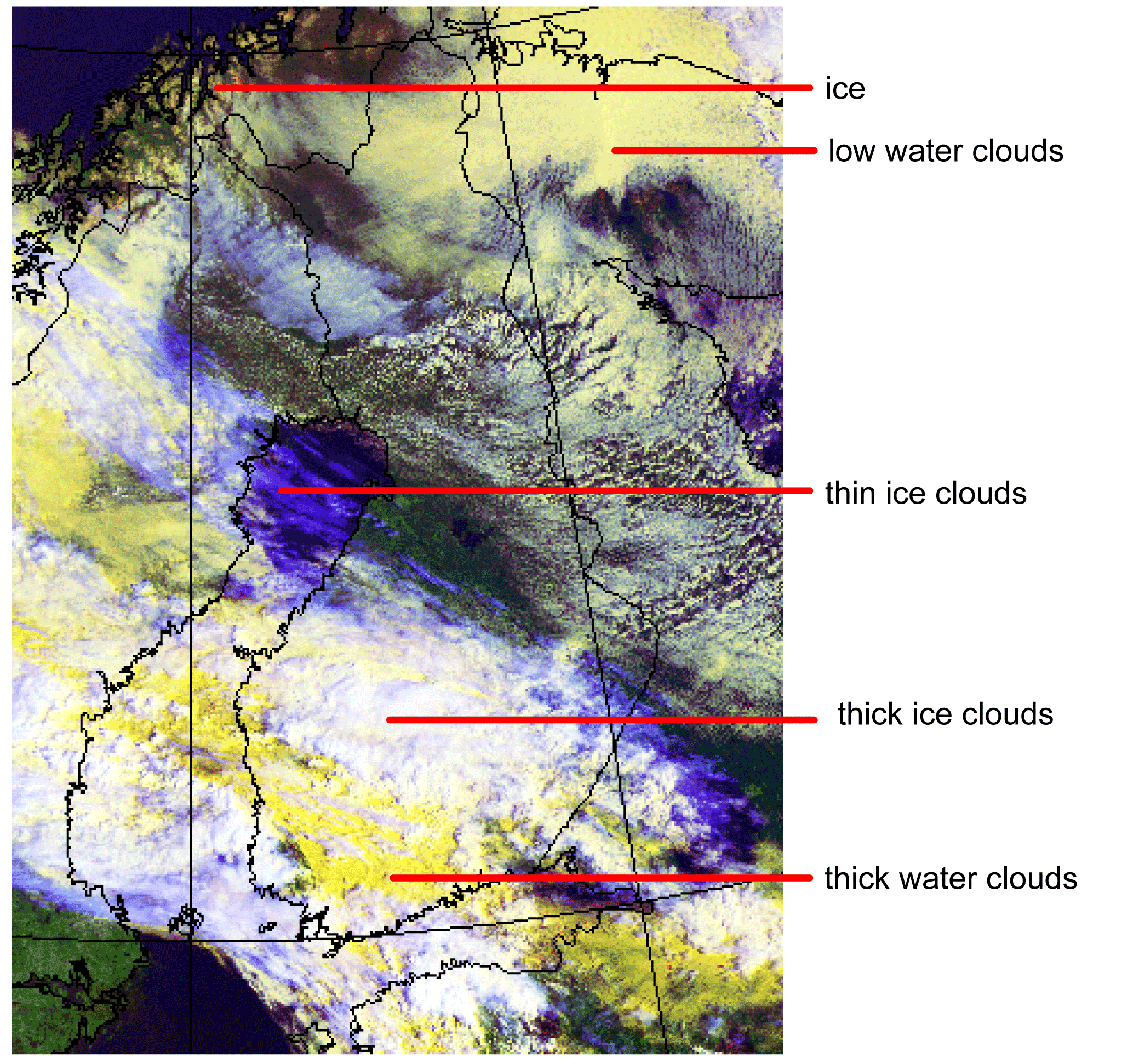
Fig. 3.10. AVHRR combination image 124