Meteorological Physical Background
The classical Norwegian model
The classical development of an Occlusion (Warm Conveyor Belt Type) is described in the well-known polar Front theory after Bergeron as the development from a Wave to an Occlusion stage.
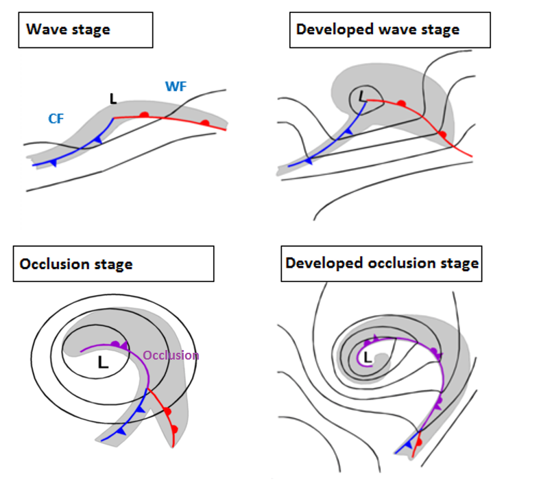
Deviations between cloud configurations in satellite images and the classical Norwegian model
There are Occlusion spirals which contradict the classical wave stage (shown above) as well as the overtaking mechanism completely. Those developments show a lower cloud spiral penetrating westward from below the Cold Front and Warm Front in the direction of the streaming (this is usually "westward" for a W-E moving system).
This type of occlusion cloud bands can much better be explained with the Conveyor Belt Model and - as the Cold Conveyor Belt manifests itself in form of a lower cloud spiral it is called a Cold Conveyor Occlusion in the Satellite Manual.
Conveyor Belt model
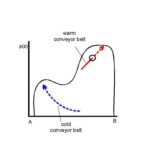
- The Cold Conveyor Belt
The lower levels of the troposphere are characterized by an ascending Cold Conveyor Belt, transporting moist and cool air ("cooler" compared with the Warm Conveyor Belt). As the Cold Conveyor Belt starts to rise in low layers from mostly east to west, it is below the Warm Conveyor Belt till it emerges at the western side and forms the lower cloud spiral of the Cold Conveyor Belt occlusion.
Further westward (in the direction of the stream) the tops of the Cold Conveyor Belt cloud spiral are becoming colder again as the Cold Conveyor Belt ascends there which changes for that part of the cloud spiral bending to the south: cloud tops become lower again as the Cold Conveyor Belt starts to descend there.
- The Warm Conveyor Belt
The mid- and upper levels of the troposphere are characterized by the moist and warm air within the Warm Conveyor Belt mainly at the anticyclonic side of the jet.
The Warm Conveyor Belt is parallel to the cloud band of the Cold Front and turns then anticyclonically parallel to the cloud band of the Warm Front (this is a difference from the Warm Conveyor Belt type of Occlusion (see Occlusion: Warm Conveyor Belt Type).
- The Dry Intrusion
The dry relative stream of the dry intrusion crosses the occlusion cloud spiral formed by the Cold Conveyor Belt at the cyclonic side of the jet in high levels. This situation restricts the development of higher cloudiness there and leads to the typical appearance in the satellite image (see Cloud structure in satellite image).
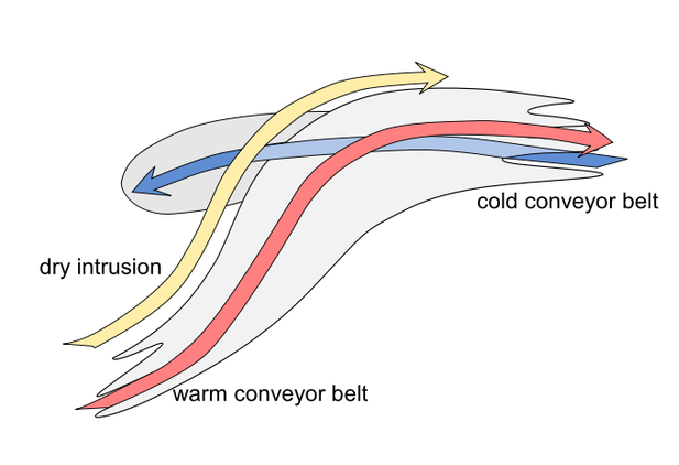
The vertical relation of these Conveyor Belts to each other
The dominant streams in this area are the Cold Conveyor Belt and the Warm Conveyor Belt.
|
|
The lower cloud spiral develops in the rising Cold Conveyor Belt, while the higher cloud band of Warm Front and Cold Front are determined by the warm conveyor belt.
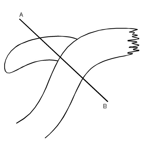
Relation between conveyor belts and Jet stream/streak
|
|
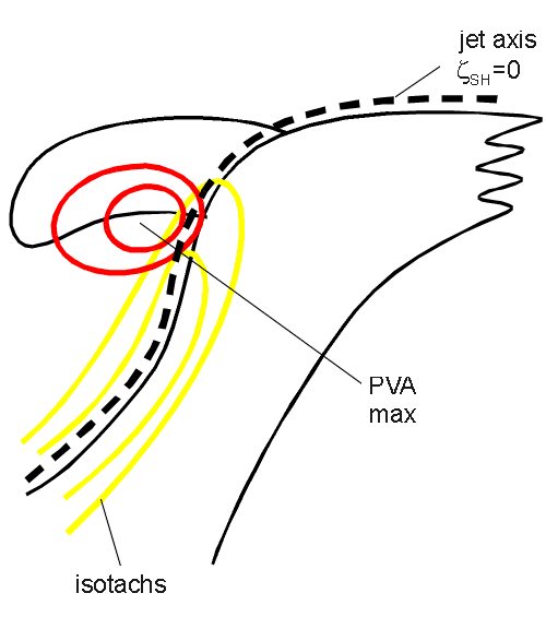
Such a distribution of conveyor belts can also be seen in relation to the upper level jet:
- The jet is parallel to the rear cloud edge of the cloud band of the Cold Front and further the leading edge of the Warm Front
- Often a jet streak exists with the CVA maximum within the left exit region; consequently this CVA maximum is superimposed on the cloud spiral of the Cold Conveyor Belt occlusion being responsible for thicker and more convective cloudiness there.
Below an example for the conveyor Belts on different (moist) isentropic surfaces for a Cold Conveyor Belt Occlusion can be seen.
|
21 June 2005/00.00 UTC - Meteosat 8 IR 10.8 image; position of vertical cross section A indicated
|
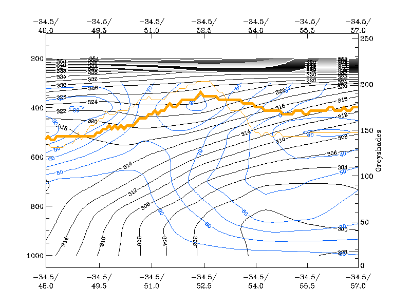
21 June 2005/00.00 UTC - Vertical cross section A; black: isentropes (ThetaE), blue: relative humidity, orange thin: IR pixel values, orange thick: WV pixel values
|

|
|
In cross section A, extending over the Atlantic from approximately 48N/34W to approximately 57N/34W, only the cold conveyor belt on the isentropic surface crosses the cross section perpendicularly. Humidity maxima and IR peaks contribute to the cold conveyor belt.
The relative streams cut the cross section perpendicularly on the isentropic surface of 314 K at a height between 650 and 850 hPa.
|
21 June 2005/00.00 UTC - Meteosat IR image; magenta: relative streams 314K - system velocity: 239° 18 m/s, yellow: isobars 328K; position of vertical cross section A indicated
|
21 June 2005/00.00 UTC - Meteosat 8 IR 10.8 image; position of vertical cross section B indicated
|

|

|
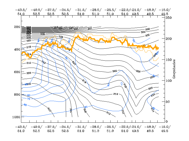
The cross section B is take perpendicular to the Warm Conveyor Belt. On the isentropic surface of 328K a rising warm conveyor belt can be observed. The relative streams of the Warm Conveyor Belt rise from 600 to 400 hPa and turn to the East and do not go into the direction of the occlusion.
|
21 June 2005/00.00 UTC - Vertical cross section; black: isentropes (ThetaE), blue: relative humidity, orange
thin: IR pixel values, orange thick: WV pixel values
|
21 June 2005/00.00 UTC - Meteosat IR image (ZAMG); magenta: relative streams 328K - system velocity: 239° 18 m/s, yellow: isobars 328K, position of vertical cross section B indicated
|
|
; magenta: relative streams 328K - system velocity: 239° 18 m/s, yellow: isobars 328K, position of vertical cross section B indicated")
|
The superimposed model fields of the isotachs and the PVA at 300 hPa are in quite good agreement with the ideal situation and can also be found in the former schematics.
|
21 June 2005/12.00 UTC - Meteosat 8 IR 10.8 image; yellow: isotachs 300 hPa, red: positive vorticity advection (PVA), black: zero line of shear vorticity 300 hPa
|
, black: zero line of shear vorticity 300 hPa")
|