06.00 UTC - Cross sections
|
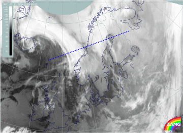
29 January 1998/06.00 UTC - Meteosat IR image; position of vertical cross section indicated
|
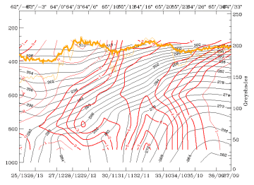
29 January 1998/06.00 UTC - Vertical cross section; black: isentropes (ThetaE), red thin: temperature advection - CA, red thick:
temperature advection - WA, orange thin: IR pixel values, orange thick: WV pixel values
|
|
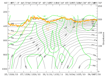
29 January 1998/06.00 UTC - Vertical cross section; black: isentropes (ThetaE), green thick: vorticity advection - PVA, green thin:
vorticity advection - NVA, orange thin: IR pixel values, orange thick: WV pixel values
|
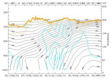
29 January 1998/06.00 UTC - Vertical cross section; black: isentropes (ThetaE), cyan thick: vertical motion (omega) - upward motion,
cyan thin: vertical motion (omega) - downward motion, orange thin: IR pixel values, orange thick: WV pixel values
|
The cross section of temperature advection (right image top) across both cloud systems shows that there is a broad frontal zone in the isentropes with two surface fronts. The first one is located around 62N/06W (leftmost edge of the cross section) and the second around 65N/13W (in the middle of the cross section). Two separate zones of maximum warm advection for both frontal zones can be seen.
The increase of PVA with height (left image bottom) is evident in the north-eastern cloud band, but the PVA maximum is found at untypically low heights, at around 600 hPa.
The maximum upward motion (right image bottom) can be found at around 65N/13E, where also snowfall was observed. The location of the maximum is probably an indication of orographic effects. (Mountain tops are around 850 - 800 hPa over the area).
As a summary it can be said that the north-eastern cloud band was more developed and active than the south-western cloud band. Later this south-western band became weaker and finally merged with the developing north-eastern cloud band. The presence of two frontal areas close to each other makes the analysis complex. It is evident, though, that the role of the south-western cloud band in the development of Lofoten Islands low pressure was minor. For this reason the analysis concentrates from this point on mainly on the north-eastern cloud band and its development.


