Meteorological Physical Background
The Polar Front Theory of cyclogenesis - the Norwegian model - was an important breakthrough in meteorology (Basics). From the meteorological/physical point of view, several processes occurring in different height layers must be taken into consideration and combined.
1. Polar Front Theory: processes in the lower layers
The processes in the lower layers are described in detail in the chapter Basics. Cold and warm airmasses move against each other, so that the main meteorological phenomena are the temperature wave and the surface pressure deepening.
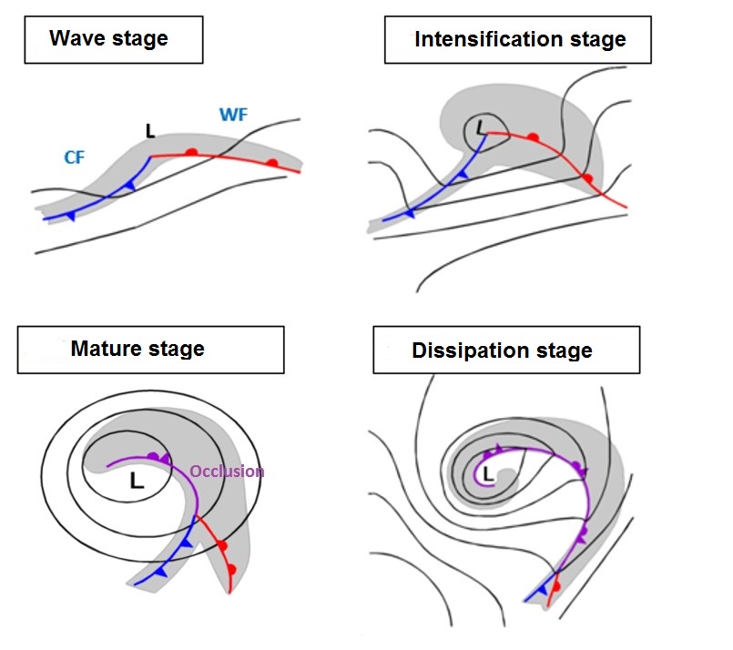
Legend: Four stages of the classical Polar Front Theory, from the "Wave stage" to the "Dissipation stage".
A small-scale disturbance in an air stream can initiate a cyclogenesis process, which starts with the development of a low centre in the lower layers of the troposphere. Consequently, cold air starts to move anticlockwise around a cyclonic low centre, pushing the warm air, which moves anticlockwise against the cold air. The cold air passes under the warm air and thereby lifts it. This leads to the development of weather fronts, which represent baroclinic boundaries. The upward vertical motions at these boundaries is responsible for the development of clouds, which form "Cold Front" (CF) and "Warm Front" (WF) cloud bands. The area between the CF and WF is called the "Warm Sector" (WS), since the warmest air occurs there. At the same time, a cloud bulge develops around the low centre. This development stage is called the "Wave Stage".
The Polar Front Theory further states that the Cold Front moves faster than the Warm Front, progressively narrowing the Warm Sector, while the cloud bulge around the low centre becomes larger and thicker. This is the "Intensification stage".
Later on, the lifted warm air, as well as the connected cloud band, start to move around the low centre forming a cloud spiral. This leads to the "Mature stage", with an occluded front and its accompanying occlusion cloud band. The centre of the surface low, which deepens during this process, remains on the cold side of the of the system.
Further development leads to the "Dissipation stage", with an Occlusion cloud band that can spiral several times around the low centre, or with a comma configuration that can be cut off in the centre of the low or with areas of dissolution of cloud mostly in the southern part of the occlusion spiral.
2. Jets and jet streaks: processes in the upper layers
The first description of the cyclogenesis based on Polar front Theory started from the observations in the lower layers, but as with time measurements from higher layers also became available and new aspects could be added. The first such observations showed high wind speeds close to the tropopause behind and above the front.
These observations reflected, of course, the jet stream in the upper layers. Jet streams are areas in the upper troposphere with very high wind speeds; the maximum speed is in the centre, while wind speeds decrease in all three directions towards the rim of the jet stream. They can extend thousands of kilometres in the horizontal but only a few kilometres in the vertical.
Jet streams develop at the boundaries between different temperate airmasses and are caused by the gradient force, which tends to balance temperature and pressure differences between different areas. Because of deflection by the Coriolis Force, as well as by orographic obstacles such as the high mountain chains, the jet stream begins to meander and breaks into jet streaks accompanying the frontal systems in upper levels. These are consequently also an important cyclogenesis phenomenon.
The jet axis, described mathematically by the line of zero shear vorticity in the upper levels, extends along the rear side of the cold front cloud band approximately to the south and south-western edge of the wave cloud bulges, in the Wave and Intensification stages. Such wind fields are, because of their inherent shear and curvature, accompanied by cyclonic vorticity and cyclonic vorticity advection (CVA). Maxima of CVA can be found in the centre of the cloud spiral in the Mature and Dissipation stages.
Jet streaks do have a characteristic distribution of these parameters of vorticity and vorticity advection at high levels, as well as in the vertical cross sections.
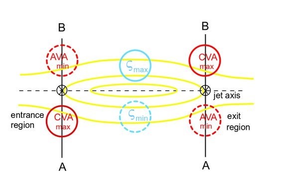
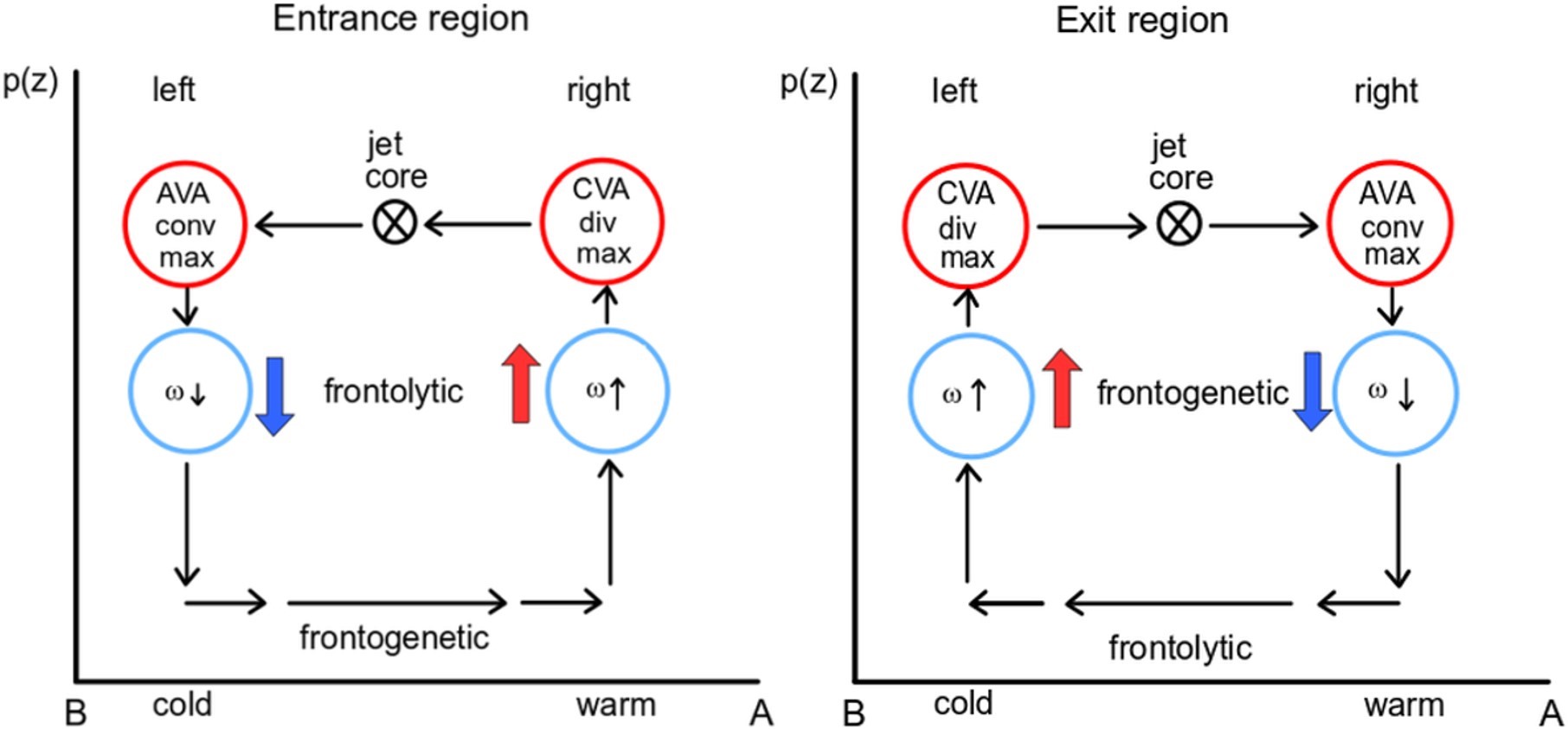
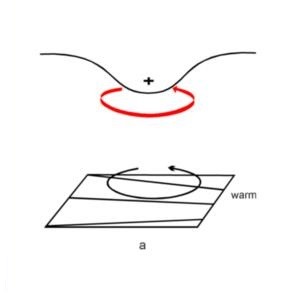
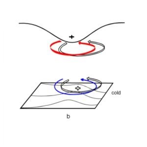
In the northern hemisphere, there are two areas in a jet streak that are preferred areas for cyclogenesis: the left exit region and the right entrance region. For secondary cyclogenesis the preferred area is the right entrance region, while the left exit region is associated more with rapid developments (Rapid Cyclognesis).
Consequently, the Wave stage is connected to cyclonic vorticity advection (CVA) at the jet level and upward motion in the air column. The Intensification and Mature stages in the development from wave to occlusion stage occur on the cold/cyclonic side of the jet streak. (Cold Conveyor Belt Occlusion, Warm Conveyor Belt Occlusion).
3. Tropopause folding, dynamical tropopause and potential vorticity (PV)
Early in the developmental history of cyclogenesis theory, a low tropopause height was found to occur at the CF and in the area of the cyclogenesis development, with a high tropopause occurring along the warm front and within the warm sector.
This is called tropopause folding and has a direct connection to the jet streak and its vertical circulation.
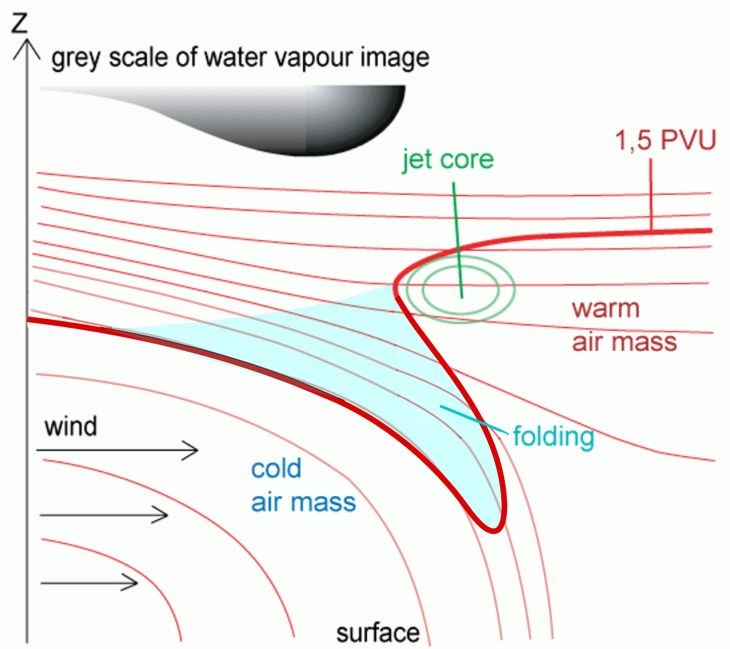
A consequence of tropopause folding is the downward protrusion of stratospheric air into the troposphere. A parameter that describes the qualities of stratospheric and tropospheric air masses very well is Potential Vorticity (PV).

The protrusion of stratospheric air into the troposphere - also called a PV anomaly - causes decreased stability and consequently an increase of vorticity. Values of PV in the stratosphere are higher than 2 PV units, and in the troposphere lower. The 2-PV-unit surface is also called the dynamical tropopause.
This is the focal point of Hoskins Theory in which the increased vorticity above and the thermal wave in lower layers form a tube in which a mutual increase of rotation takes place.
For most of the cyclogenesis events starting in the right entrance region of a jet streak, the PV anomaly does not reach downward into layers close to the surface but only into moderate heights, approximately to 500 - 600 hPa. However, there are cyclogenesis types where the PV tube does reach down to very low levels; these are called "Rapid cyclogenesis" and are described in detail in this manual (Rapid Cyclognesis).