Cloud Structure In Satellite Images
Cold Fronts are usually associated with cold advection behind the frontal zone and warm advection ahead of it, but sometimes the whole front is under cold advection. These fronts are called Cold Fronts in Cold Advection, abbreviated CF in CA.
CF's in CA form mostly over the Atlantic, but also in the north-eastern parts of Europe after some way across the continent, and are more common in the winter than in the summer. The CF's in CA stage generally lasts 0,5-2 days, although in winter 3-4 day developments sometimes occur.
CF's in CA are often old, dissolving kata-type fronts in occluded cyclones. The upper level cloudiness is slight or nonexistent. In the earlier stages there is also often a significant dark stripe behind the front due to the very cold dry air.
Appearance in the basic channels:
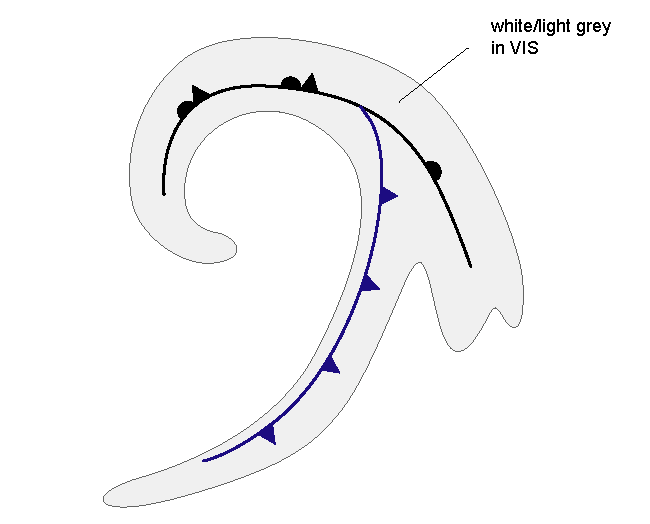
- In VIS images a white/light grey cloud band with some broken structure
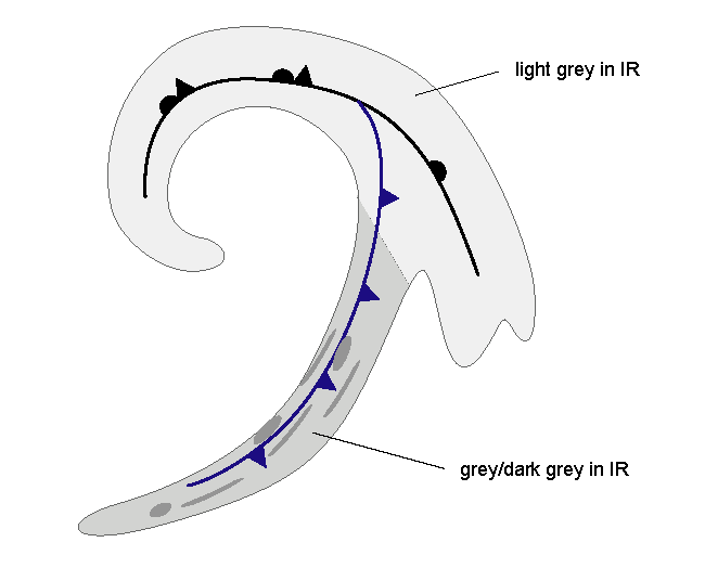
- In IR images a grey, broken cloud band, which is clearly darker than other frontal parts (e.g. warm front or occlusion) of the system
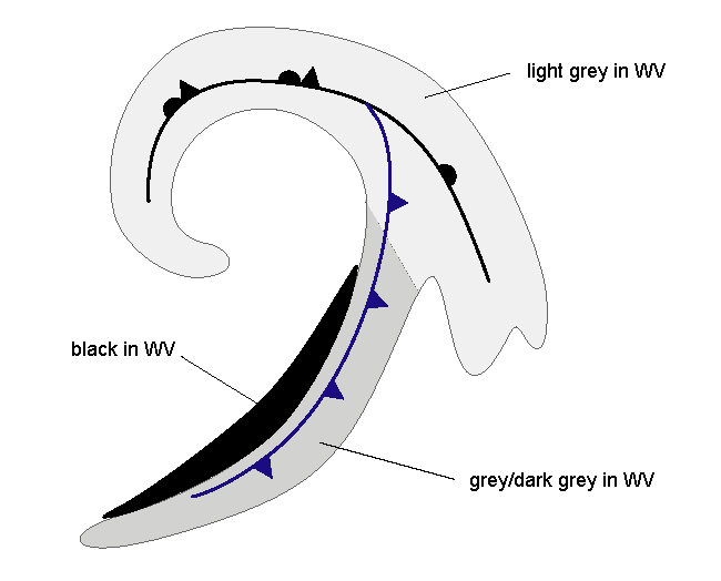
- In WV images a grey cloud band with often a black stripe behind it. In small and dissolving systems, the black stripe is missing. Additionally, in some cases, other systems like jet clouds or an upper level wave can hide the black stripe. Generally in the end of the CF in CA stage, the dark stripes weaken and disappear.
|
|
|
Appearance in the basic RGBs
Airmass RGB:
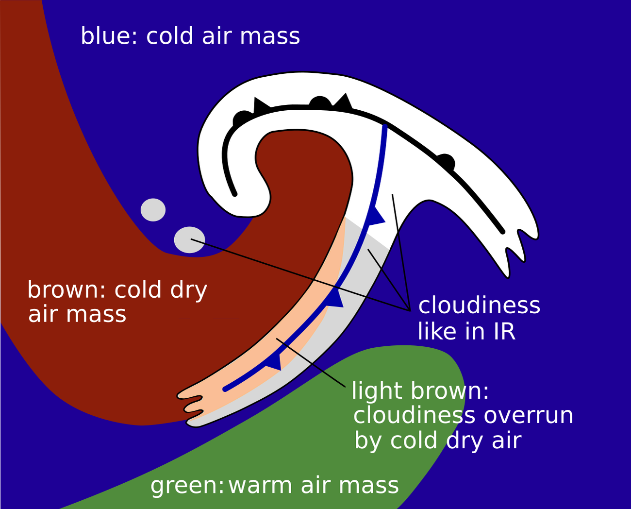
In front of the cloud band, depending on the geographical location, there is cold air showing as blue colours and /or warmer air showing as greenish colours. The latter appears more in southern latitudes as well as in the southern parts of the warm sector.
At the rear side of the CF in CA the cold and dry air from N-NW regions shows as blue (cold air) and brownish (cold and dry air) areas. The dark stripe in the WV image can be seen as a brown stripe in the Airmass RGB.
The cloud band looks very similar in the Airmass RGB to its appearance in the IR image. However, there are often areas where a brownish shadow is superimposed, indicating penetrating dry air.
Dust RGB:
The Dust RGB discriminates between cloud-free areas in blue colours and areas with mostly low clouds in ochre colours.
As the cloudiness of a CF in CA often is less pronounced than for an active CF, the low level cloudiness with ochre colours dominates, although there are sometimes red-brown stripes indicating thicker clouds.
 |
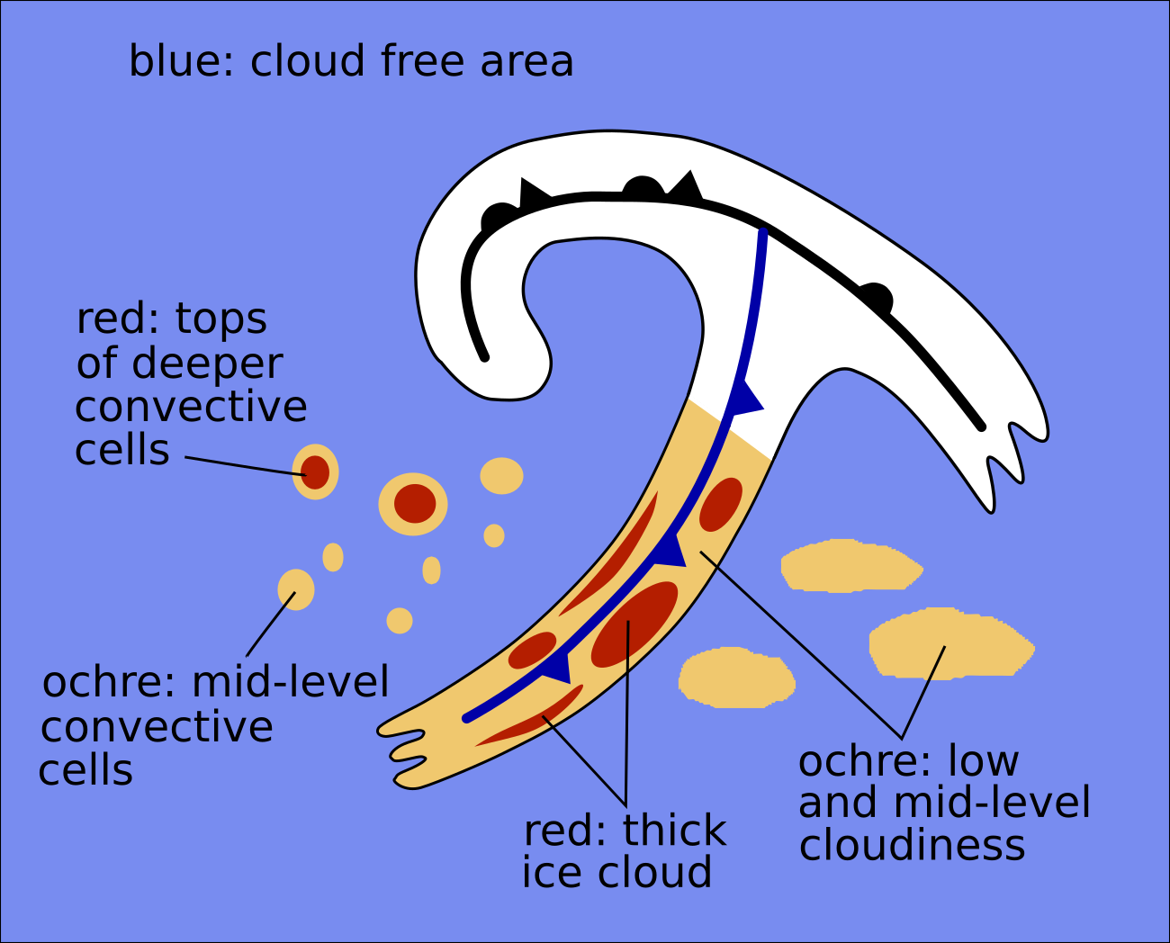 |
Basic RGBs schematics. Left: Airmass RGB; right: Dust RGB
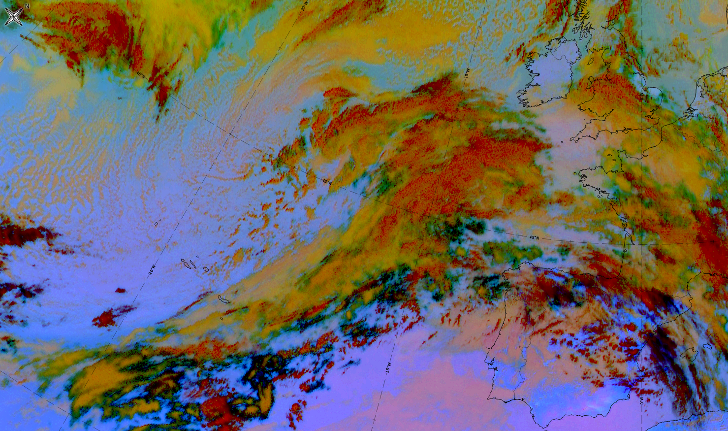
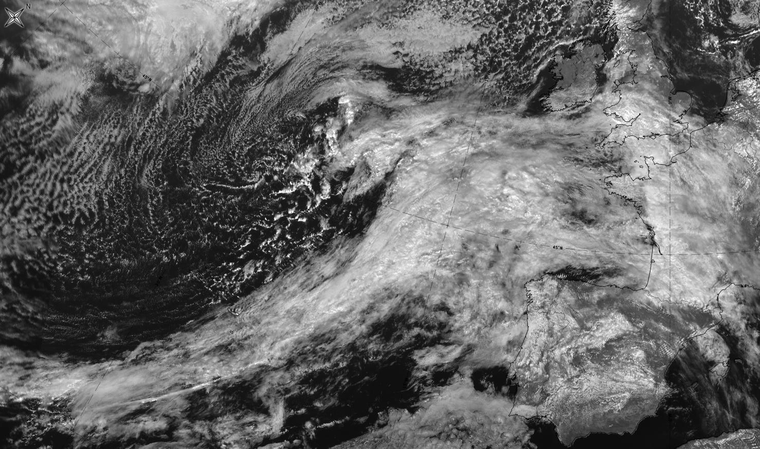
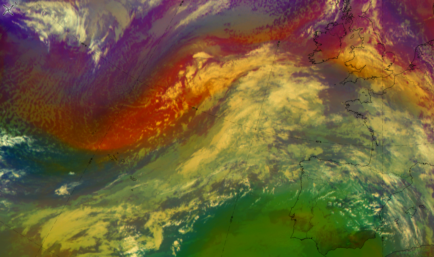
A good example of a CF in CA can be seen in the data from 4 March 2020 at 12 UTC.
|
|
|
|
|


| IR | Grey areas with some brighter cloud fibres above; grey areas in the Cold Front band are darker than in the occlusion and warm secto.r |
| HRV | White and broken cloudiness. |
| WV | Grey to dark grey band; black stripe at the rear representing sinking dry air. |
| Airmass RGB | As the cloud band is in southern latitudes, there are greenish colours indicating warm air masses superimposed with some brighter cloud patches; a broad brown area represents sinking dry air at the rear. |
| Dust RGB | Ochre colours indicate mid-level clouds. |
When defining the type of the CF in CA, the following aspects are to be taken into account:
- Along the front there can be several types of Cold Fronts present, that is CF, CF in CA and CF in WA.
- In the earlier stages there might still be some upper cloudiness connected to the front.
- Quite often (in over 70% of the cases) some other upper cloudiness overruns CF in CA: most common is Jet Fibres, the other possibility is an Upper Wave. This might make the images look like an ordinary Cold Front, and hide the black stripe behind the CF in CA.
- CF in CA can change back into CF or even into CF in WA before it is dissolved.
- Sometimes in the north CF in CA can be found already in a wave before the occlusion stadium. These fronts look like conventional Cold Fronts in the beginning, but the cloudiness reduces rapidly.
- The dark stripes are clear only in the beginning of the development, afterwards they grow lighter and smoother.
The last stage of CF's in CA can be:
- most often a common CF, after the cold advection has reduced, or warm advection from a WF or WCB is effecting it
- CF in CA can also dissolve in itself when the cyclone is very old and there are no other features nearby having any influence
- a Split Front, although this is rare.