Meteorological Physical Background
Cbs and MCSs form in strong convective processes. These processes and the parameters which describe them are discussed in detail in the Basics chapter "Numerical parameters for small scale convective cloud systems" (see Basics ).
The structures described below have been derived from radar observations, as satellite images cannot resolve small-scale single storms or substructures of MCSs.
The life cycle of a single cell
The life cycle of a single cell can be separated into three stages:
- Developing stage
- Mature stage
- Dissipating stage
Developing stage
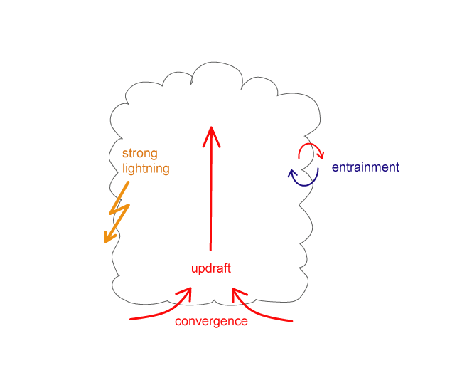
The following features characterize the developing of a single cell:
- The developing stage lasts 5 to 10 minutes
- A distinct single updraft is prevailing
- The diameter of the cell is between 2 and 8 km
- Entrainment at the cloud edges causes the reduction of water vapour content, resulting in the evaporation of water droplets. This causes cooling and consequently reduction of buoyant energy. A supply of humidity from lower levels supports further growth of the developing cell.
- In the end of this stage lightning is most intense
Mature stage
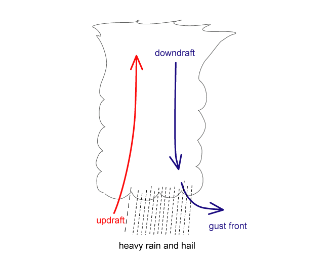
The following features characterize the mature stage of a single cell:
- The mature stage lasts 25 to 30 minutes
- Downdrafts develop and are accelerated as a consequence of cooling by the evaporation of cloud droplets
- Hail stones are no longer kept aloft by the updraft and fall
- The updraft starts to weaken because the warm humid air below the cell is replaced by cool air from the downbursts
- The downdraft initiates successive developments of new cells which can be observed as gust fronts
- Rain and hail are most intense; hail with a diameter over 5 cm develops in the updrafts of the order 30-40 m/s
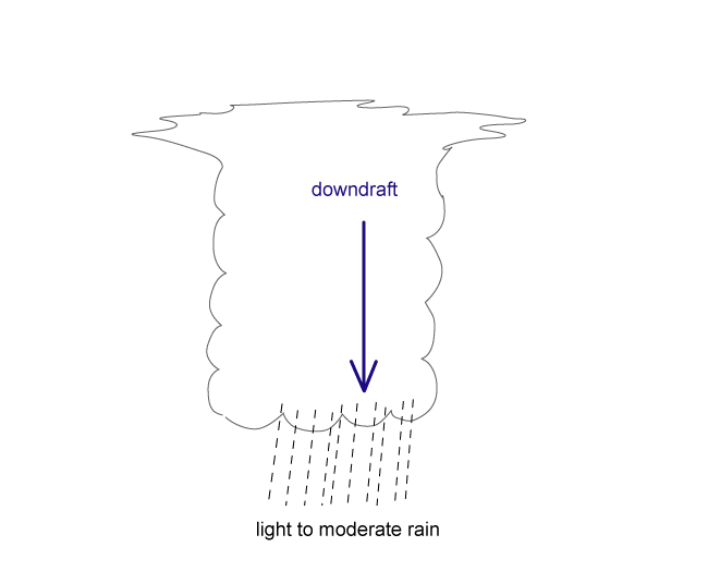
Dissipating stage
- Downdrafts kill the updraft and the Cb dissipates
The role of vertical wind shear
The life time and intensity of a Cb and MCS depend upon the vertical wind shear:
- The shear perpendicular to the convective line supports updraft
- Most important is the shear in the lowest layer reaching from the surface up to 2-3 km
- Cells developing within strong vertical shear have long lifetime and severe weather
- Most intense thunderstorms develop when there is change both in speed and direction of the wind
Multi-cell storms
Multi-cell storms develop from a single cell:
- The single cell produces a gust front around it; the gust front lifts the air to the level of free convection (LFC), and new cells (daughter cells) form
- New cell growth is favoured on the downwind side of the moving single cell where the lift is the greatest
- Daughter cells develop mostly in the right leading side of the mother cell (so called "right movers"), but they can also develop in the left side (so called "left mover"). They can be distinguished from the structure of the vertical wind shear.
- Left movers move faster than mean low level flow, whereas right movers move slower than it
- Tornadoes are uncommon in left movers
- The diameter of the daughter cells is 3-5 km, and the distance to the centre of the thunderstorm is approximately 30 km.
- The mother cell and daughter cells form together a Multi-Cell Storm. New cells develop ahead of the leading edge of the storm while older cells dissolve in the rear parts
- Daughter cells develop more rapidly than the mother cell, because entrainment is not slowing the process on the rear side. If the sequence of successive cells is short enough, the Multi-Cell Storm can turn into a Super Cell Storm.
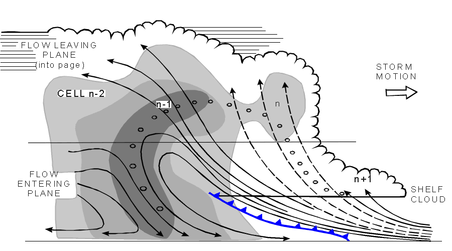
The diagram above (adapted from Browning et al., 1976; Greyshades represent radar reflectivities of 35, 45 and 50 dBz) shows a typical cross section through a Multi-Cell Storm. There are four successive cells in different stages of development, each of which takes about 15 minutes:
- Cell n-2 is already in dissipating stage
- Cell n-1 is in mature stage and forms the centre of the storm
- Cell n (a daughter cell) is in developing stage
- A shelf cloud n+1 with a crisp, flat base indicating an active updraft forms ahead of cell n
During the warm season, MCS triggering peaks at around 2 pm (local solar time) due to the heating in the lower levels of the atmosphere. However, in Europe, where MCS last in average 5.5 hours, 20% of MCS triggering happens during the night (between 10 pm and 9 am), when other lifting mechanisms are expected to play a key role, as low level convergence, mid-level cold pools or out-flows of pre-existing MCSs.
In the European region, details on MCS Climatologies based on satellite or radar data can be found, eg., for Switzerland (Schiesser et al, 1995), Spain (AEMET, 1999) and Finland (Punkka et al, 2009; Saarikalle, 2009). A wider (satellite derived) MCS climatology covering western Europe (including surrounding Atlantic coasts), western Mediterranean Sea and northern Africa is presented in Morel and Senesi (2002b).
A particular mechanism under which convective cells (embedded in a certain flow) form approximately in the same location as pre-existing cells during several hours - train effect - is investigated in the special investigation chapter.
Observations and verification by radar
See chapter Key parameters for typical radar products. In CAPPI products the following features typical for MCSs can be seen, although they are not very clear in every case (depending also on the position of the radar compared with the convective system).
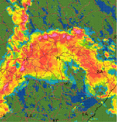
Bow echo:
- Bow or hook shaped strong (>40 dBz) echo area
- Very strong echoes surrounded by weaker ones within the echo area
- Begins as a straight line, develops into a bow shape and finally into a Comma shape
- Lasts for a few hours
- The region near the centre of the bow is ahead of strong surface winds, thought to be associated with a rear inflow jet entering the MCS
Gust front:
- Occurs ahead of the leading edge of the reflectivity pattern
- Clear air echoes coming from insects and debris
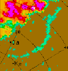
Side-lobe echoes:
- Often seen in radar displays of storms producing hail
- Running parallel to the distance marker (from the radar position)
- Are reflections from strong cumulonimbus, created by side-lobes of the antenna beam