Special Investigation:
Weather Event of the 13th -15th July 2012
A COL that occurred over the southern parts of South Africa during this time, resulted in heavy rainfall that damaged property over the south-eastern parts of South Africa (Eastern Cape Province), the department of health stated that a number of houses collapsed due to the heavy rainfall and that three people died after a housing structure collapsed during a flood which occurred about 2.5km outside the town of Umtata. A local newspaper also reported that it snowed in the south-western parts of South Africa (Western Cape Province) in and around the town of Oudtshoorn.
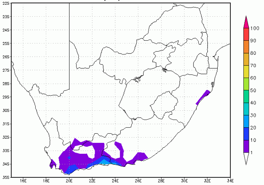
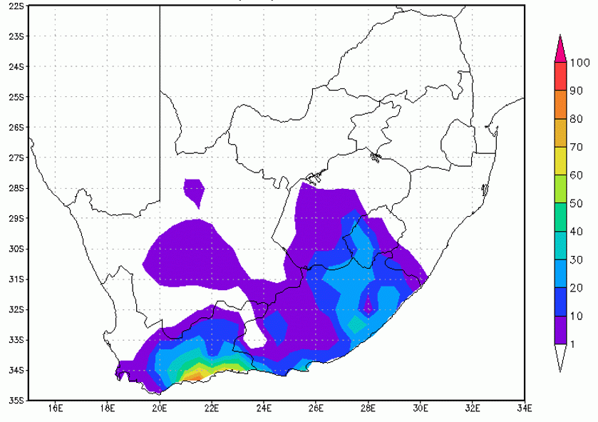
| 24 hour rainfall totals from 12-13 July 2012 | 24 hour rainfall totals from 13-14 July 2012 |
|
|
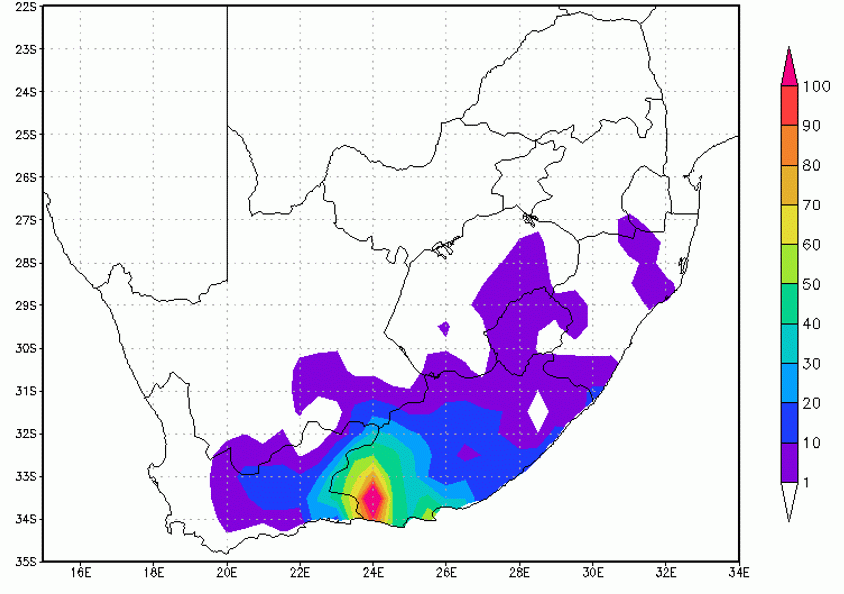
| 24 hour rainfall totals from 14-15 July 2012 | |
|
The rainfall totals measured by the South African Weather Service (SAWS) for this COL event, clearly show that the southern coastal and adjacent interior regions of South Africa were the areas affected by the COL from a precipitation perspective, with the south-eastern parts of South Africa also receiving up to 30mm of rain between the 13th and 14th of July 2012. The southern coastal belt received over 60mm of rainfall during this period, and 24 hours later, on the 15th, measured over 100mm rain. The areas of heaviest precipitation coincide well with the areas of deepest convection seen to the east and the southern parts of the COL in the satellite imagery and NWP fields. The areas also correspond to where the maximum uplift was seen in the vertical cross sections, and to where deepest moisture was found.
|
|
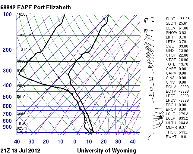
The skew-T gram show to the left, represents the vertical profile of the atmosphere at Port Elizabeth, on the south-east of South Africa. the profile is very moist from the surface up to 450hPa. Speed and directional wind shear is evident between the surface and 850hPa, with winds shifting from light south-westerly to strong north-easterly in a matter of a few thousand feet. The upper Jet is present between 150hPa and 200hPa, where wind speeds are above 80Kt, from the north-west. The freezing level is located at 800hPa, which is low enough for snowfalls to be expected on the higher topography over the southern parts of South Africa.
|
Typical Synoptic sequence and weather associated with COLs around South Africa
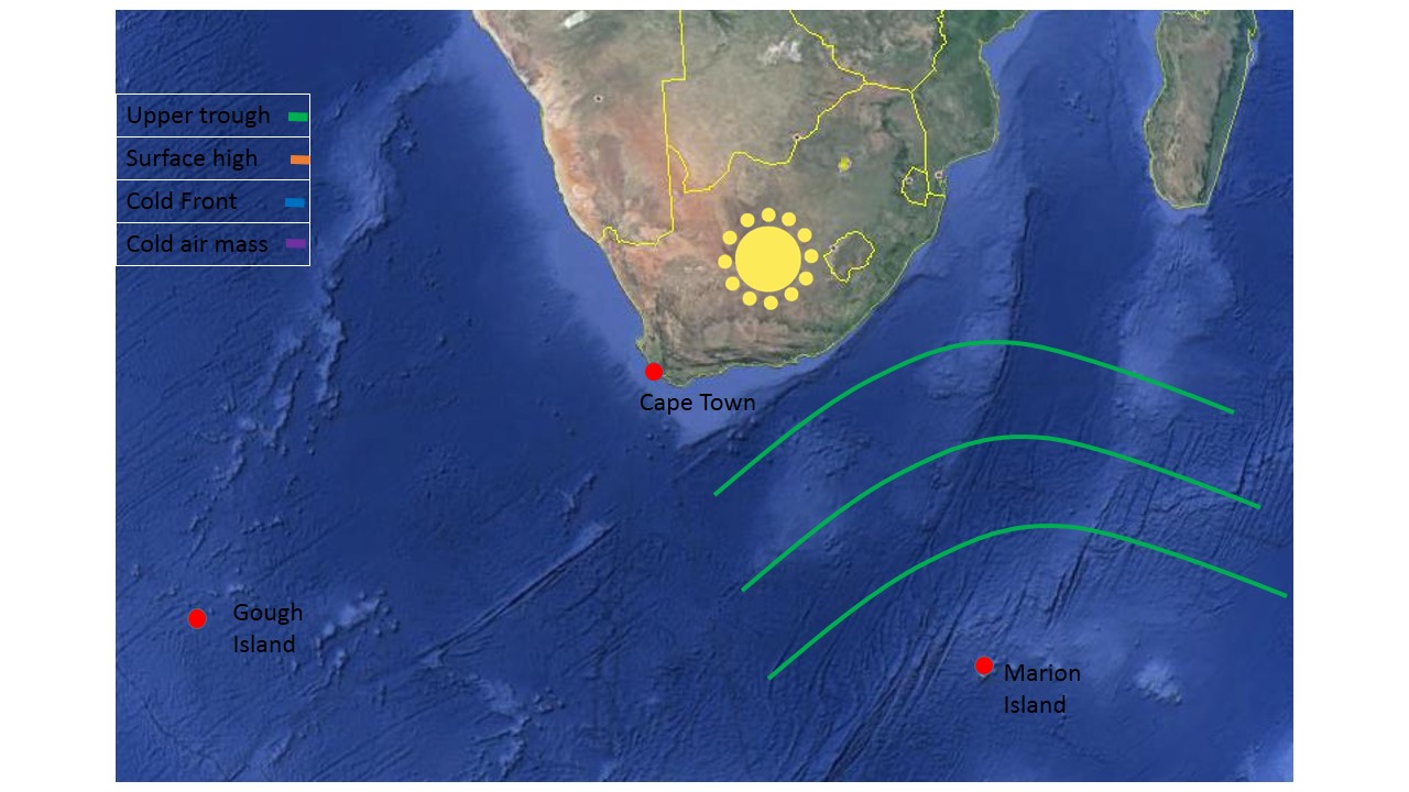
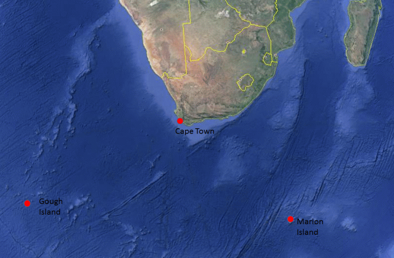
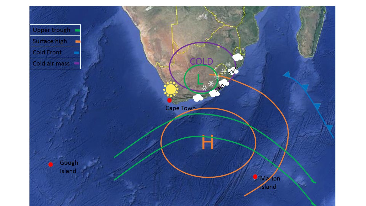
The map below depicts the Gough Island, Cape Town, Marion Island triangle which will be referred to in the following text. .
Stage 1
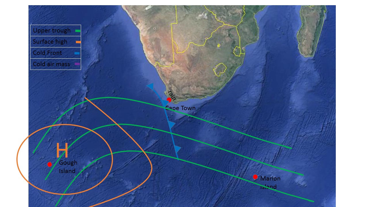
During the Upper trough stage of the COL development, one can expect an upper tropospheric long-wave trough located south-west of South Africa, in a triangular area formed between Gough Island, Cape Town and Marion island. A stronger than usual surface high pressure system can be expected near Gough Island and a cold front should be approaching Cape Town. Pressure would be falling rapidly ahead of the approaching Front at Cape Town, and rising behind the front.
Stage 2
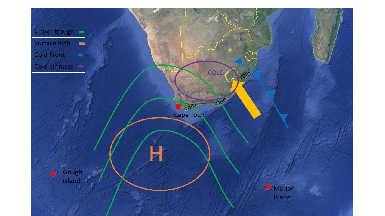
The second stage as when the amplitude of the upper atmospheric trough increases and becomes more "pointed". at the surface, the anticyclone (high pressure) moves south-eastwards and the onshore flow component of the wind increases over the South African east and south coast regions. At the surface, the cold front will be positioned over the eastern parts of South Africa, with the post-frontal cold air having spread over the southern and south-western parts of the country.
Stage 3
By this stage the COL has developed in the upper troposphere. The surface high pressure system continues to move eastwards but maintains its intensity and the onshore flow along the east coast of South Africa remains. By this stage, cold air would have advanced over most of South Africa. If the surface high remains strong and potentially intensifies, COL can essentially move very slowly eastwards.
Stage 4
It is during this final stage that the COL will collapse. This process can happen very rapidly and often catch forecasters off guard. during this stage, the upper air high which was trailing the COL, will weaken into a ridge at this point as well.