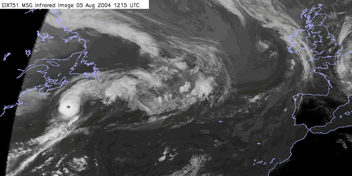
Although this case study focuses primarily on the transition from Tropical cyclone to Extra-tropical cyclone, some background information about the structure and history of the tropical cyclone is important, because of the impact this can have on the transition process.
Tropical Depression formed on the 31st July, 2004 in the western Atlantic at 30.6N 78.6W, approximately 500 KM east of the Georgian coast and with a central pressure of 1010 hPa. Storm track
Tropical cyclones that develop in the North Atlantic Ocean are steered by the dominant flow circulating the sub-tropical Azores high pressure belt.

05 Aug 2004/12:15 UTC - Meteosat 8 IR10.8 image
|
WV Imagery (Meteosat 8 channel 7.3): time sequence
Water vapour imagery is an important forecasting tool which enables us to observe the broadscale patterns such as jets and upper features. During this section we will describe the broadscale patterns and feature apparent during the tropical phase.
Combined satellite imagery RGB : time sequence
An important diagnostic tool is the use of RGB's to aid in the analysis of development. In this section we will investigate the similarities that can be ascertained by using RGB composites. in this section we will primarily be using the convective RGB composite (WV6.2-WV7.3, IR3.9-IR10.8, NIR1.6-VIS0.6)
IR and WV Imagery (Meteosat 8 channel 10.8, 6.2, 7.3) and MSLP: time sequence
In this chapter we will use the Meteosat IR image and surface analysis overlays to establish the surface pressure fields and movement of the system.
Sea surface temperatures: time sequence
In the following chapter we will investigate the sea temperature anomalies that occurred during the hurricane season during 2004, and how this affected the development region.
QuickSCAT wind (NOAA): time sequence
Satellite derived wind fields using NOAA QuickSCAT data.
Synoptic diagnosis:
Moving slowly in a northwesterly direction and deepening, Alex became a Tropical Storm on the 1 st August. Turning to the northeast and intensifying further, Alex achieved hurricane status on the 3rd, slightly earlier than average, brushing the north-eastern United States at Cape Hatteras . It reached a maximum depth of 957 hPa on the 5th which it maintained as far north as 42 N. Maximum sustained winds reached 105 KT.
Hurricane Alex was a Category 3 Hurricane early in the season, and maintained this intensity to a all time record latitude for an Atlantic system up until 2004.
Summary of the investigations in this chapter
In this chapter some important things should be summarised before going on:
Tropical Depression formed on the 31st July, 2004 in the western Atlantic at 30.6N 78.6W, approximately 500 KM east of the Georgian coast and with a central pressure of 1010 hPa.
Tropical cyclones that develop in the North Atlantic Ocean are steered by the dominant flow circulating the sub-tropical Azores high pressure belt.
Moving slowly in a northwesterly direction and deepening, it became a Tropical Storm on the 1st August. Turning to the northeast and intensifying further, Alex achieved hurricane status on the 3rd, slightly earlier than average, brushing the north-eastern United States at Cape Hatteras. It reached a maximum depth of 957 hPa on the 5th which it maintained as far north as 42 N. Maximum sustained winds reached 105 KT.
The time of year is important because of the related factors such as sea surface temperatures, which are highest in September, and the strength of the mid-latitude "westerlies", which generally increase through the season. If the jet is too weak the hurricane will move only slowly over colder ocean temperatures. The tropical cyclone’s energy source is cut off and any remaining structure then dissipates before it reaches a development area.
The time of highest sea temperatures frequently coincides with the peak in tropical cyclone activity, when re-intensification after transition is most likely to occur at higher latitudes. The Atlantic hurricane season varies year on year however officially the hurricane season runs from June to November each year. The latitude of transition increases from 30-35 degs N early and late season to 40-50 N mid season, in response to the rise and fall of sea surface temperatures and jet stream movement and intensity.
Further important factors
-
Seasonal / climatological variations (eg La Nina/ El Nino),
-
Location of formation
-
time of year
-
Sea temperatures,
- Storm track and storm longevity
Can all help determine the characteristics of transition and the degree of any reintensification.